The best walks and hikes around Tanis
4.4
(2179)
25,601
hikers
192
hikes
Hiking trails around Tanis are primarily found in the flat, coastal plains of Normandy, France, offering expansive views of Mont Saint-Michel and its surrounding bay. The region is characterized by open fields, river estuaries, and low-lying terrain, with minimal elevation changes. These routes provide opportunities to explore the unique tidal landscapes and historical sites of the area on foot.
Best hiking trails around Tanis
- The most popular hiking route is Grande Rue – The mountain loop from Pontorson, an…
Last updated: October 8, 2026
4.7
(22)
181
hikers
Moderate hike. Good fitness required. Easily-accessible paths. Suitable for all skill levels.
8
hikers
24.5km
06:12
40m
40m
Hard hike. Very good fitness required. Easily-accessible paths. Suitable for all skill levels.

5.0
(2)
9
hikers
Easy hike. Great for any fitness level. Easily-accessible paths. Suitable for all skill levels.
2
hikers
10.3km
02:41
80m
80m
Moderate hike. Good fitness required. Easily-accessible paths. Suitable for all skill levels.
4.7
(22)
250
hikers
Moderate hike. Good fitness required. Easily-accessible paths. Suitable for all skill levels.
Get access to more routes and recommendations from other explorers.
Already have an account?
Our route recommendations are based on thousands of hikes, rides, and runs completed by other people on komoot.
Start today with a free account
Your next adventure awaits.

Tips from the Community

Mont-Saint-Michel is a world-famous rocky island and commune on the border between Normandy and Brittany in France. Crowned by a monumental, medieval Benedictine abbey, this architectural marvel has been a UNESCO World Heritage site since 1979. The bay of the mount is also known for Europe's strongest tides, with a tidal range of up to 14 meters.
2
0

You have to experience Mont Saint-Michel at least once. Unfortunately, the parking fees are outrageous! 3 hours parking = €20 On the other hand, the shuttle bus for the approx. 2.5 km distance is free. But when you're already here, ....?
0
0

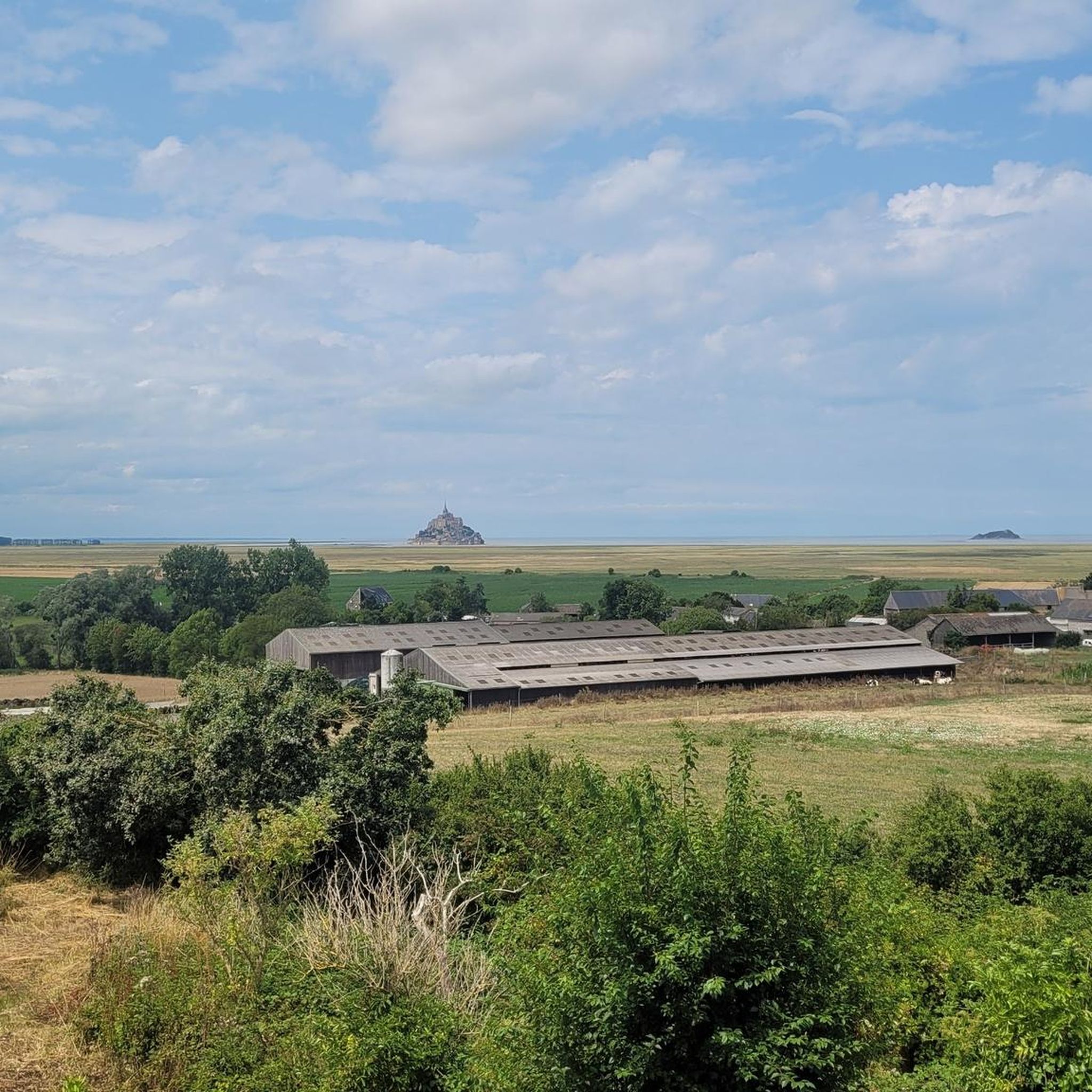
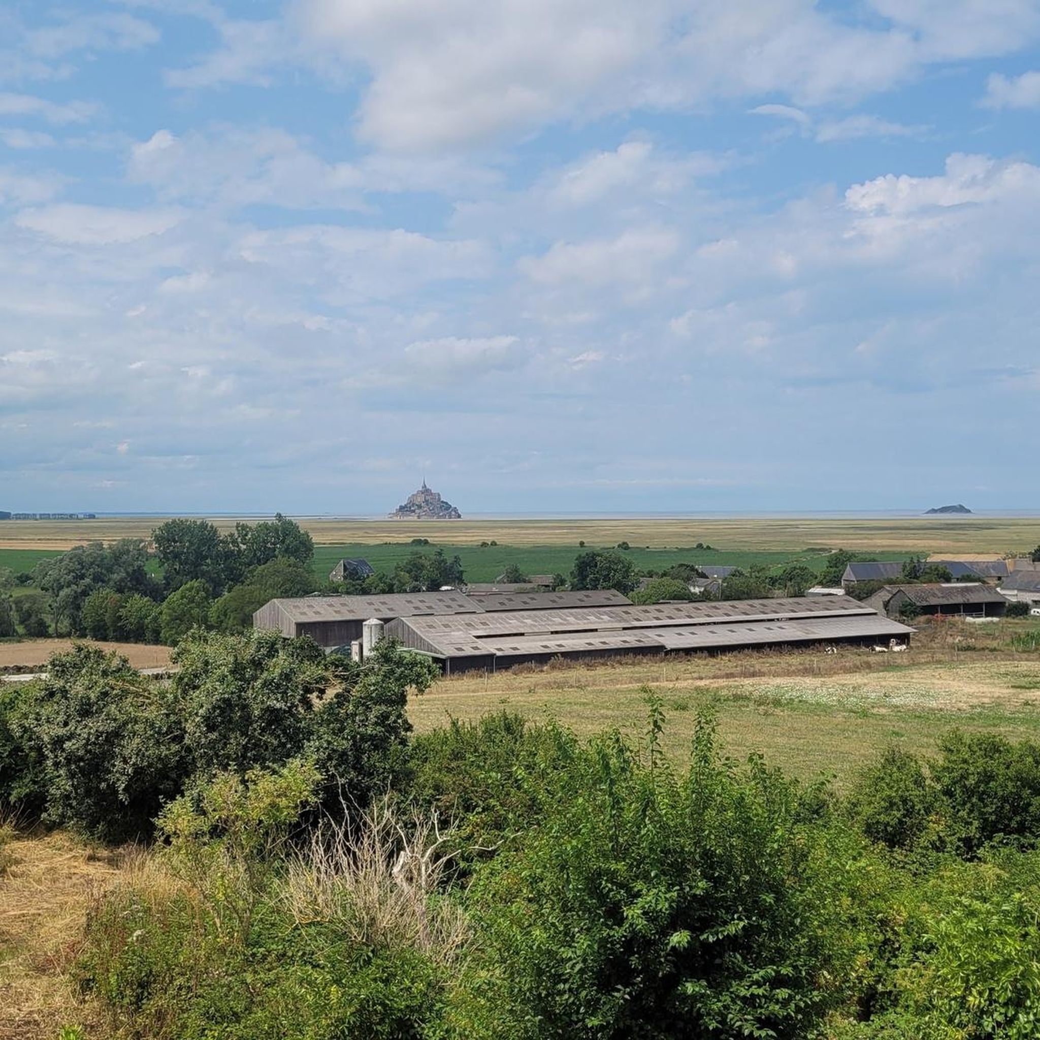
The footpath along the Couesnon to the dam already offers an impressive view of Mont-Saint-Michel. From here, the path with an unobstructed view leads across the salt marshes and the bay, with the landmark of Normandy impressively rising against the wide landscape. Especially in calm weather and with changing light, atmospheric views emerge of Mont-Saint-Michel, the course of the Couesnon river, and the tide-shaped surroundings.
13
0
The Couesnon dam (Barrage du Couesnon) was completed in 2009 and is part of the measures to preserve the bay of Mont-Saint-Michel. The facility regulates the water flow of the Couesnon and supports the natural removal of sediments by the tides. This is intended to counteract the increasing silting up of the bay and preserve the special character of Mont-Saint-Michel as a tidal island. The dam also offers a popular viewpoint with a view of Mont-Saint-Michel and the surrounding salt marshes.
3
0
On the vast salt marshes of the Mont-Saint-Michel bay, sheep graze, making a significant contribution to the maintenance of this unique landscape. Suffolk rams are often used for breeding the salt marsh lambs. This robust meat sheep breed is easily recognizable by its black head and black legs. The animals feed on salt-tolerant plants such as glasswort and cordgrass, which gives the meat of the regionally known salt marsh lambs its special flavor. At the same time, grazing helps to preserve the species-rich salt marshes.
4
0
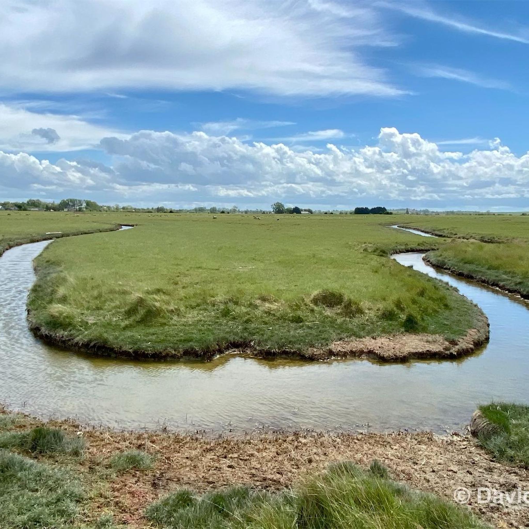
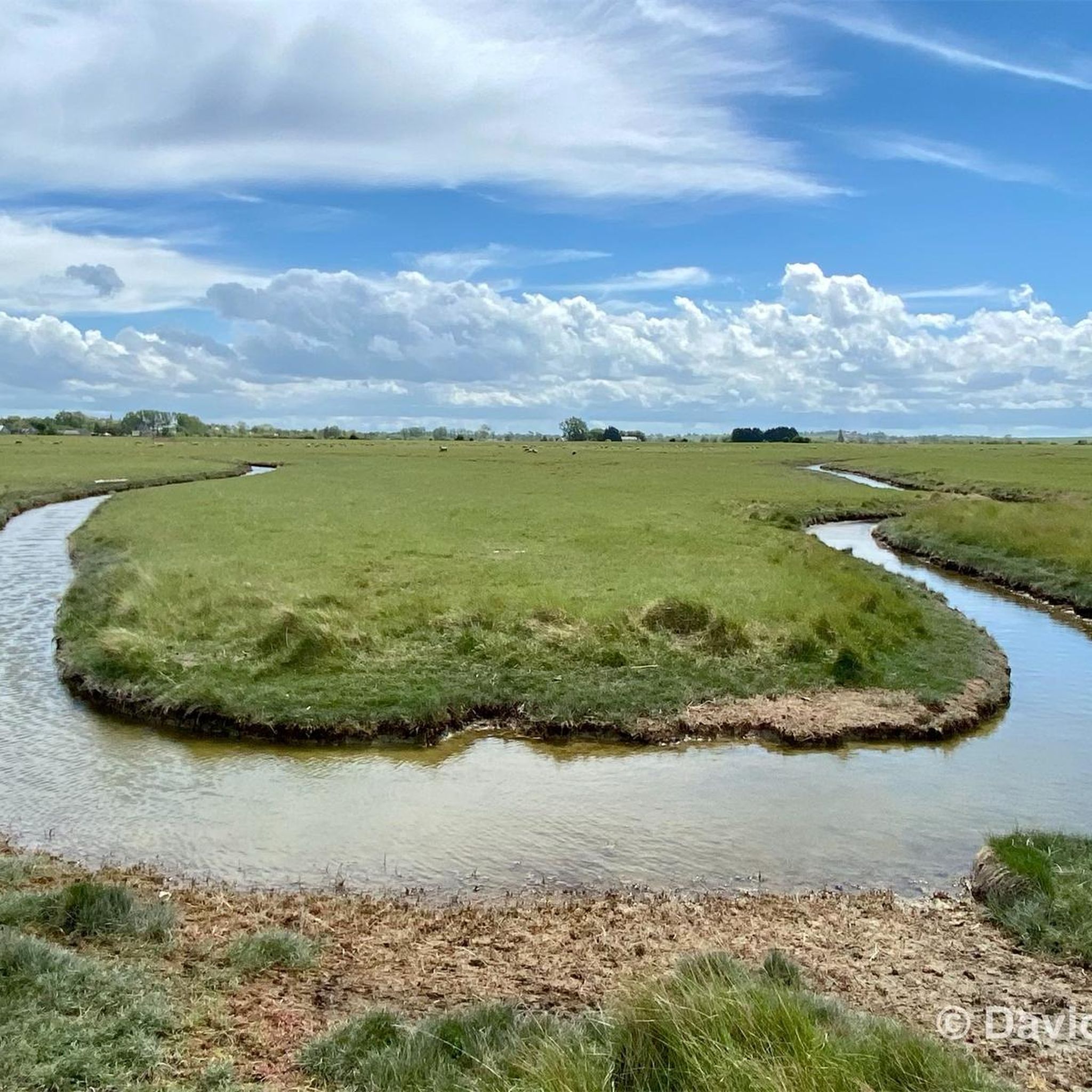
The salt marsh path (* public access is via an unlocked gate) leads through the expansive landscape of the bay and offers a particularly impressive way to experience the famous Klosterberg from a quieter perspective. The paths run through the prés-salés (salt marshes) shaped by the tides, which are crisscrossed by numerous tidal creeks. These small watercourses regularly change their appearance with ebb and flow, creating popular photo opportunities together with the grassy areas and reflections.
33
0
Numerous tidal creeks crisscross the meadows, channeling seawater through the vast area at low and high tide. These small watercourses, with their reflections and wide grassy areas, also form a popular photo spot and offer impressive motifs, especially with Mont-Saint-Michel in the background.
35
0
Numerous inlets criss-cross the meadows and channel seawater through the vast terrain at low and high tide. These small watercourses with their reflections and the wide grassy areas also form a popular photo spot and offer impressive motifs, especially with Mont-Saint-Michel in the background.
1
0
Frequently Asked Questions
Where exactly is the Tanis region for hiking located?
The Tanis region for hiking, as featured in this guide, is located in the flat, coastal plains of Normandy, France. It offers expansive views of Mont Saint-Michel and its surrounding bay, characterized by open fields, river estuaries, and low-lying terrain. This is distinct from the archaeological site in Egypt or the paleontological site in North Dakota.
What kind of terrain can I expect on hiking trails around Tanis?
The hiking trails around Tanis are primarily found in flat, coastal plains. You can expect open fields, river estuaries, and low-lying terrain with minimal elevation changes. The landscape is defined by unique tidal features and offers panoramic views, particularly of Mont Saint-Michel.
Are there many hiking trails available in Tanis?
Yes, there are plenty of options for hikers. The Tanis region offers over 190 hiking routes, catering to various preferences and skill levels.
What are the easiest hiking trails for beginners or casual walkers?
For an easy and scenic walk, consider the View of Mont Saint-Michel – Grande Rue loop from Ardevon. This 4.2-mile (6.7 km) path provides direct views of Mont Saint-Michel and is generally completed in under two hours. Another easy option is the View of Mont Saint-Michel – La Roche Torin loop from Courtils, which is 7.7 km long and also offers beautiful views.
Are there any longer or more challenging hikes in the Tanis area?
Yes, for those seeking a longer challenge, the Grande Rue – View of Mont Saint-Michel loop from Courtils is a difficult 13.9-mile (22.3 km) trail that takes approximately 5 hours 38 minutes to complete, leading through the coastal landscape. There are 5 difficult routes in total in the region.
What are the most popular hiking routes in Tanis?
Among the most popular routes is the Grande Rue – The mountain loop from Pontorson, a moderate 8.3-mile (13.3 km) trail offering varied scenery. Another local favorite is the Le Marquis de la Guintré – La Roche Torin loop from Huisnes-sur-Mer, a moderate 13.6 km route.
What interesting landmarks or attractions can I see along the hiking trails?
Many trails offer stunning views of the iconic Mont Saint-Michel. You can also explore the Couesnon at Beauvoir, the Grouin du Sud, and various viewpoints like the Beautiful view of Mont-Saint-Michel (Barrage), which provide excellent photo opportunities.
Are there many circular walking routes in Tanis?
Yes, many of the trails in Tanis are designed as loops, allowing you to start and end at the same point. Examples include the Grande Rue – The mountain loop from Pontorson and the View of Mont Saint-Michel – Grande Rue loop from Ardevon.
What do other hikers say about the trails in Tanis?
The trails in Tanis are highly rated by the komoot community, with an average score of 4.5 stars from over 2000 reviews. Hikers often praise the expansive views of Mont Saint-Michel, the flat and accessible terrain, and the opportunity to explore the unique coastal and tidal landscapes.
Is the Tanis region suitable for family-friendly hikes?
Yes, with 118 easy routes available, Tanis offers many family-friendly options. The generally flat terrain and scenic views make it enjoyable for all ages. Look for shorter, easy loops that provide good views without being too strenuous.
What is the best time of year to go hiking in Tanis?
Given its coastal location, hiking in Tanis is generally pleasant during spring, summer, and early autumn. These seasons offer milder weather and longer daylight hours, ideal for enjoying the open landscapes and views of Mont Saint-Michel. Always check local weather forecasts before heading out.
Most popular attractions around Tanis

Get inspired with the komoot mobile app


Explore more
Browse the best Hikes in other regions.
