The best hikes from bus stations around Réserve naturelle des Aiguilles rouges
4.6
(8350)
107,318
hikers
13
hikes
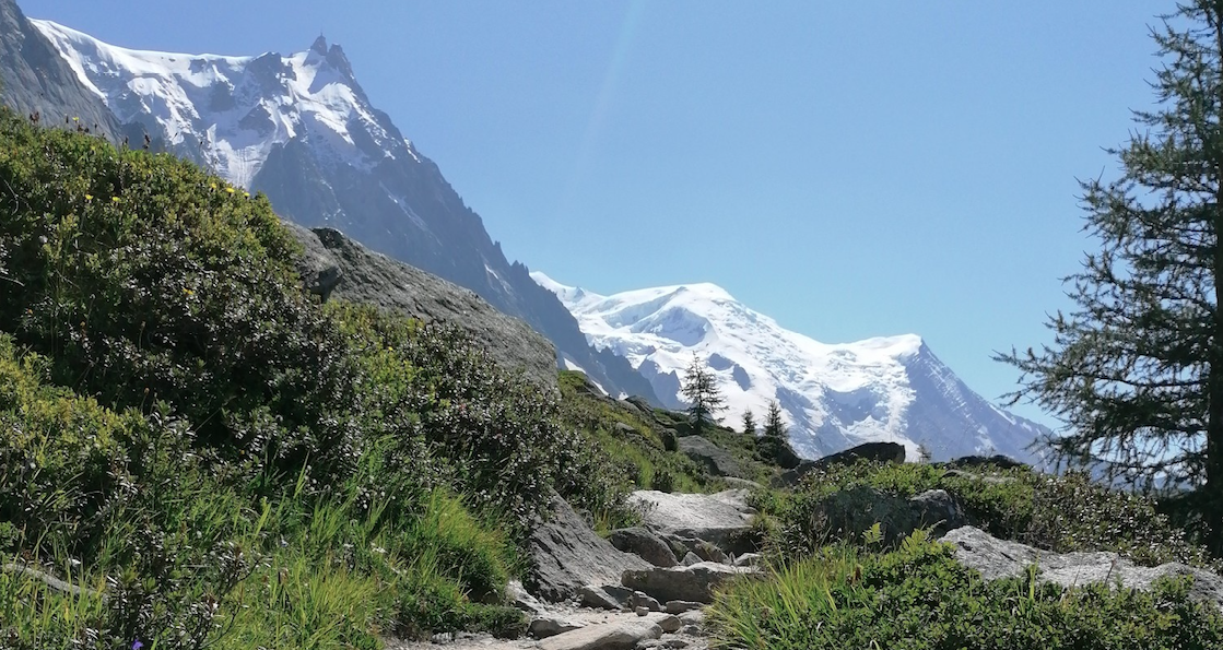
Bus station hiking trails around Réserve naturelle des Aiguilles rouges offer access to a high-altitude alpine environment in southeastern France. The reserve spans approximately 3,300 hectares, with elevations ranging from 1,200 m to 2,965 m. This region is characterized by siliceous and crystalline rock formations, providing panoramic views of the Mont Blanc massif and its glaciers. The landscape features diverse ecosystems, including spruce forests, rhododendron moorlands, alpine meadows, and mineral terrain with moraine scree and mountain lakes.
Best bus station…
Last updated: July 26, 2026
4.8
(20)
462
hikers
7.43km
04:18
740m
740m
Hard hike. Good fitness required. Sure-footedness, sturdy shoes and alpine experience required.
4.6
(17)
258
hikers
7.84km
04:05
660m
660m
Moderate hike. Good fitness required. Mostly accessible paths. Sure-footedness required.

Sign up for free
5.0
(2)
97
hikers
5.63km
03:15
590m
590m
Moderate hike. Good fitness required. Mostly accessible paths. Sure-footedness required.
4.3
(3)
21
hikers
4.75km
01:25
120m
120m
Easy hike. Great for any fitness level. Easily-accessible paths. Suitable for all skill levels.
5.0
(2)
29
hikers
4.19km
02:15
380m
370m
Moderate hike. Good fitness required. Mostly accessible paths. Sure-footedness required.
Get access to more routes and recommendations from other explorers.
Sign up for free
Already have an account?
Our route recommendations are based on thousands of hikes, rides, and runs completed by other people on komoot.
Start today with a free account
Your next adventure awaits.
Login or Signup
Popular around Réserve naturelle des Aiguilles rouges


Other adventures around Réserve naturelle des Aiguilles rouges


Tips from the Community


Beautiful scenery, must be especially nice in spring with all the melt water!
0
0

Emblematic place that is usually the turning point to return to La Flegere.
2
0

Lovely little nature museum, with videos, models and stuffed animals! Nice coffee and good value.
0
0


wow, the landscape is majestic. This reminds me of the slopes at https://slope3.io
0
0

Ascent to the ladders of Chésérys. Whoever hikes the Tour du Mont Blanc (TMB) will be aware of this section of the trail, which is one of the best known and most anticipated on the route. It is a series of metal ladders that serve the ascent of a rocky massif on the hiking trail. Although care must be taken and caution exercised, these metal ladders are not difficult to tackle but, they can sometimes be an obstacle to those who suffer from vertigo.
2
1
La Tête aux Vents is one of the emblematic passages of the Tour du Mont Blanc (TMB), just above the Chamonix valley.
2
1
Frequently Asked Questions
How many bus-accessible hiking trails are there in Réserve naturelle des Aiguilles Rouges?
There are 13 bus-accessible hiking trails detailed in this guide, offering a variety of experiences for different skill levels. You'll find 1 easy route, 11 moderate routes, and 1 difficult route to explore.
What kind of views can I expect on these bus-accessible hikes?
Many of the bus-accessible trails offer spectacular panoramic views, particularly of the Mont Blanc massif and its glaciers. For instance, the View of the Argentière Glacier – Grand Balcon Sud Trail loop from Col des Montets provides stunning vistas of the Argentière Glacier. The Aiguilles Rouges range itself acts as a natural balcony facing these majestic peaks.
Are there any easy bus-accessible hikes suitable for beginners or families?
Yes, there is one easy bus-accessible route in this guide. The Réserve naturelle des Aiguilles Rouges also features accessible nature trails, often marked by granite blocks, which are perfect for leisurely walks and admiring wildflowers. While this guide focuses on specific routes, these nature trails offer a gentle introduction to the area's beauty.
What natural attractions can I see along the bus-accessible hiking trails?
The trails offer access to diverse natural features. You can discover serene mountain lakes like Lac Blanc and Lacs des Chéserys, or witness the impressive Bérard Waterfall. Many routes also pass through varied flora, from spruce forests to rhododendron moorlands.
Are there any circular routes available from bus stops?
Yes, several routes in this guide are circular, allowing you to start and end at the same bus stop. An example is the Montets Pass – La Poya loop from Col des Montets, which offers a moderate circular hike.
What wildlife might I encounter on these hikes?
The Réserve naturelle des Aiguilles Rouges is home to abundant wildlife. You might spot unafraid marmots, as well as chamois and ibex in the western parts of the reserve. Birdwatchers can look out for golden eagles, ptarmigans, and Alpine choughs, especially above 2000 meters.
What is the best time of year to hike these bus-accessible trails?
While the reserve offers activities year-round, summer is generally ideal for hiking the trails. The weather is more stable, and the diverse flora is in full bloom. Some areas also cater to winter activities like snowshoeing, but for hiking, summer provides the best conditions.
What do other hikers say about the bus-accessible trails in Réserve naturelle des Aiguilles Rouges?
The area is highly rated by the komoot community, with an average score of 4.6 out of 5 stars from over 7,700 ratings. Reviewers often praise the stunning Mont Blanc views, the diverse landscapes, and the accessibility of the trails, even those starting from bus stations.
Are there any specific viewpoints or mountain passes accessible by bus-friendly trails?
Yes, many trails lead to notable viewpoints and passes. For example, the Montets Pass is a common starting point for several routes and offers an information center. You can also find trails leading to areas with views of Mont Blanc from Le Brévent, though some may require additional effort beyond the immediate bus stop.
Can I find trails that offer views of multiple glaciers?
Absolutely. Routes like the View of the Tour Glacier – View of the Argentière Glacier loop from Col des Montets allow you to experience the grandeur of more than one glacier from accessible starting points.
Most popular routes around Réserve naturelle des Aiguilles rouges
Most popular attractions around Réserve naturelle des Aiguilles rouges

Get inspired with the komoot mobile app


Explore more
Browse the best Hikes in other regions.
