Easy hikes and walks in Las Trampas Regional Wilderness
4.7
(151)
2,377
hikers
30
hikes
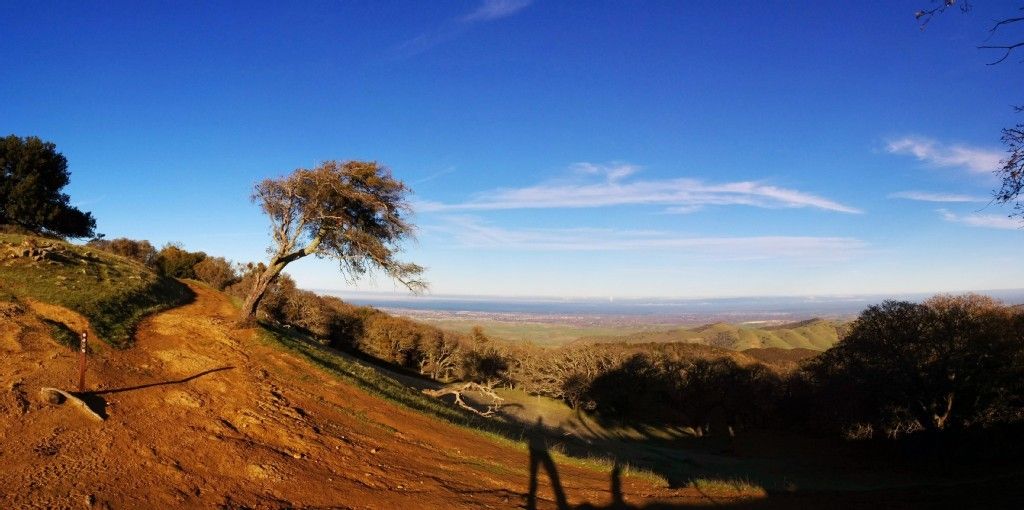
Hiking in Las Trampas Regional Wilderness offers a variety of landscapes, characterized by hilly ridges and valleys carved by creeks. The region features diverse plant communities, including chaparral and oak woodlands, with seasonal wildflowers. Panoramic views of surrounding valleys and the San Francisco Bay are accessible from various points within the wilderness. The area's geological formations include exposed rocks with ancient fossils.
Best easy hiking trails in Las Trampas Regional Wilderness
- The most popular easy hiking route is Ringtail Cat,…
Last updated: October 25, 2026
1
hikers
4.22km
01:26
260m
140m
Embark on the Ringtail Cat, Madrone and Point of No Return Loop for an easy hiking experience that packs a punch. This 2.6-mile (4.2 km) route guides you through shaded…
1.92km
00:50
280m
0m
Embark on the Rocky Ridge View Trail for an easy hike offering expansive panoramas across the East Bay. This route covers 1.2 miles (1.9 km) with a steady climb of…

4.43km
01:36
270m
230m
Embark on the Rocky Ridge View Trail for an easy hike that offers rewarding vistas. This route covers 2.8 miles (4.4 km) and involves an elevation gain of 883 feet…
5.0
(1)
6
hikers
6.13km
01:53
210m
210m
Embark on an easy hike along the Bollinger Creek to Calaveras Ridge Trail Loop, a 3.8-mile (6.1 km) route that takes about 1 hour and 52 minutes to complete. You'll…
4.23km
01:26
220m
220m
Embark on an easy 2.6-mile (4.2 km) hike along the Madrone Trail and Dewies Birthday Loop, where you'll experience a pleasant escape into nature. This single-track path winds through vibrant…
Get access to more routes and recommendations from other explorers.
Already have an account?
Our route recommendations are based on thousands of hikes, rides, and runs completed by other people on komoot.
Start today with a free account
Your next adventure awaits.
Popular around Las Trampas Regional Wilderness
Other adventures in Las Trampas Regional Wilderness

Tips from the Community

For the Rocky Ridge trail hike, I suggest to have a hat, hiking poles, sun-glasses and of course water. Most of the trail is without any shade. Depends on the season, some portions of the trail could be muddy. Park the car in the parking lot at the end of Bollinger Canyon Road. If parking lot is full you can park along the road. This is the staging area and the start and end of our hike is here. Restrooms are available only at this place. To start the Rocky Ridge Trail, go to the north-west corner of the parking lot (north of the restrooms) and start going up on the paved road. Note that most of the climb is this segment, but afterwards the trail is pretty easy. No shade on Rocky Ridge, some shade on Elderberry.
0
0

This trail is a beautiful, easy path full of wildflowers, grasslands and green hillsides ladened with oak and madrone. Several trails connect to this one for multiple options to explore this gorgeous preserve.
0
0
This popular single-track trail is a great starting point in both directions for variations of exploring the preserve. The trail connects Dewie's Birthday Trail to the north and the south to the Madrone Trail for multiple loop options.
0
0
This trailhead is an excellent staging area centrally located within the Park, making it a great starting or resting point for multiple hike variations. There is plenty of parking, restrooms and drinking water. The Sycamore Trail is closed temporarily due to a landslide, so check the Park's website for updates. The Cuesta Trail is an excellent alternative if you plan to hike the Ridge View Trail loop.
1
0

From this ridge you embrace quite a few points of view. Starting with the valleys of Ignacio, San Ramon and Amador. Further on, Mount Diablo stands out.
0
0

Restrooms, water, and shade. Good starting or rest point, near the middle of the park, almost all trails lead down to this area.
0
0
Rock 2 is a hill of 622m altitude providing great views across the Diablo Range ( https://www.komoot.de/tour/7308564 ) from its North-West corner of the Las Trampas Regional Wilderness, which offers 5,342 acres of wilderness and an expanded trail system. Rocky Ridge Road is the most direct trail to come up from the main parking. For park info go to http://www.ebparks.org/parks/las_trampas For more hiking details see http://bahiker.com/eastbayhikes/lastrampas.html or the other sections of this loop here: https://www.komoot.de/tour/7109119
0
0
Frequently Asked Questions
How many easy hiking trails are available in Las Trampas Regional Wilderness?
There are 11 easy hiking trails in Las Trampas Regional Wilderness, offering a variety of experiences for different skill levels. In total, the area features 29 routes, with options ranging from easy to difficult.
What kind of terrain can I expect on easy hikes in Las Trampas Regional Wilderness?
Easy hikes in Las Trampas Regional Wilderness often feature a mix of hilly ridges and valleys, with some elevation changes that still provide rewarding views without being overly strenuous. You'll encounter diverse plant communities, including chaparral and oak woodlands, and in spring, the hillsides are vibrant with wildflowers like lupine and California poppies.
Are there any easy loop trails in Las Trampas Regional Wilderness?
Yes, there are several easy loop trails. A popular option is the Ringtail Cat, Madrone and Point of No Return Loop, which is 2.6 miles (4.2 km) long. Another great choice is the Bollinger Creek to Calaveras Ridge Trail Loop, covering 3.8 miles (6.1 km) with varied terrain.
What are the typical distances and durations for easy hikes here?
Easy hikes in Las Trampas Regional Wilderness typically range from 1.2 miles (1.9 km) to about 3.8 miles (6.1 km). Depending on the route, you can expect to spend anywhere from 1 hour to 2 hours 15 minutes on the trail, allowing for a relaxed pace and time to enjoy the scenery.
What kind of views can I expect on easy trails?
Even on easy trails, you can find excellent viewpoints. For instance, the Rocky Ridge View Trail offers views from Rocky Ridge. From higher points like Las Trampas Ridge, you can often see the Ygnacio, San Ramon, and Amador valleys, Mount Diablo, and even the Carquinez Straits. Rocky Ridge itself provides vistas of San Francisco, the Golden Gate, and Mount Tamalpais.
Are there any interesting natural features or landmarks to look out for?
Yes, the wilderness is rich in natural features. You might spot exposed rocks with clam shell fossils over ten million years old, a testament to the area's geological history. The park also features diverse plant life, from chaparral on southern slopes to California bay laurel and coast live oak. While many waterfalls are secluded and difficult to access, the general landscape of hilly ridges and creek valleys is a highlight.
What wildlife might I encounter on the trails?
Las Trampas Regional Wilderness is home to a variety of wildlife. Hikers might spot black-tailed deer, coyotes, and bobcats. Birdwatchers can look for various species, including hawks and occasionally golden eagles. During warmer months, be aware that rattlesnakes are also present.
When is the best time of year to visit for easy hikes?
Spring is an excellent time to visit, as the hillsides burst into a 'sea of color' with abundant wildflowers. The weather is generally pleasant for hiking. While beautiful, be mindful that rattlesnakes are more active during warmer months.
Is there parking available at the trailheads?
Yes, there is a main parking lot available near the primary access points for the wilderness. This makes it convenient to start your easy hiking adventure.
What do other hikers say about the easy trails in Las Trampas Regional Wilderness?
The routes in Las Trampas Regional Wilderness are highly rated by the komoot community, with an average score of 4.6 stars from over 50 reviews. Hikers often praise the varied terrain, the rewarding views, and the opportunity to experience nature close to urban areas.
Are dogs allowed on the easy hiking trails?
While the region is generally dog-friendly, specific trail regulations can vary. It's always best to check local signage at the trailhead for any restrictions or leash requirements to ensure a pleasant experience for everyone.
Are there any picnic areas along or near the easy trails?
Yes, the park features picnic areas such as Steelhead and Shady, which are conveniently located near the main parking lot. These spots provide a great place to relax and enjoy a meal before or after your hike.
Most popular routes in Las Trampas Regional Wilderness
Most popular attractions in Las Trampas Regional Wilderness

Get inspired with the komoot mobile app


Explore more
Browse the best Hikes in other regions.
