Attractions and Places To See around Langenhorn - Top 20
Best attractions and places to see around Langenhorn, located in Nordfriesland, Schleswig-Holstein, offer unique insights into the Wadden Sea National Park. This coastal region is characterized by its extensive salt marshes, dikes, and the unique Hallig landscape. Visitors can explore the natural environment and learn about the area's ecological significance. The district provides opportunities for outdoor activities along the North Sea coast.
Best attractions and places to see around Langenhorn
- The most popular attractions is Salt Marsh Trail to Hamburger Hallig, a trail that features the largest salt marsh area on the open North Sea, spanning 1,000 hectares. This route offers a unique experience through the Wadden Sea.
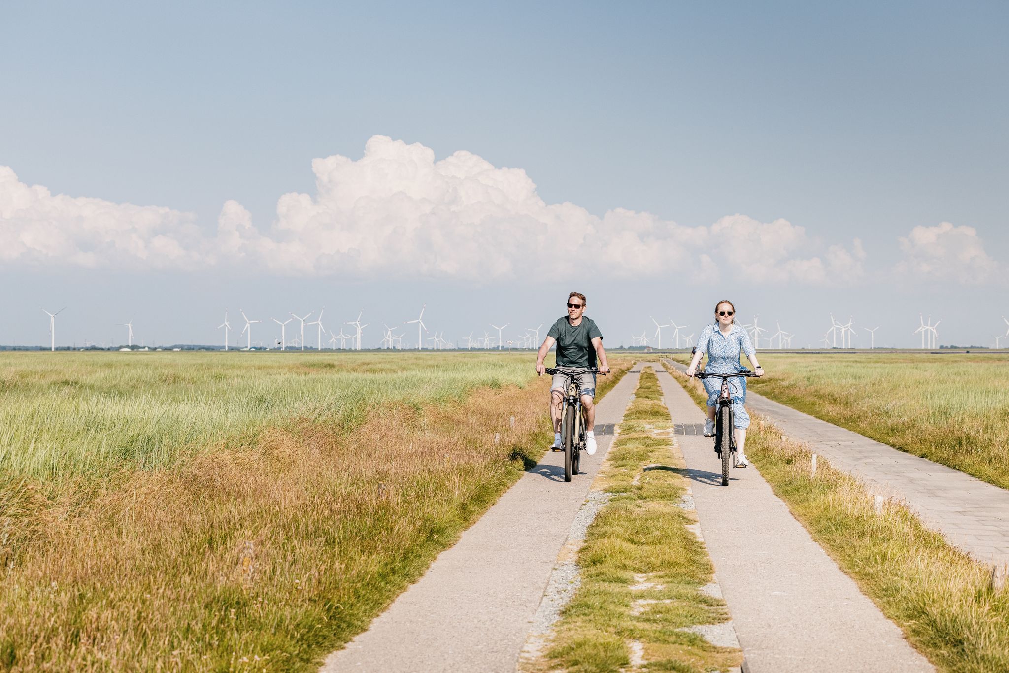
- Another must-see spot is Hauke-Haien-Koog Dike Cycle Path, a cycle way. This path runs along the Wadden Sea, offering views and shelter from the wind due to the dikes.
- Visitors also love NABU Information Hut on Schafsberg (Hamburger Hallig), an information point within the Wadden Sea National Park. It serves as a starting point for excursions and provides information on bird migration events.
- Langenhorn is known for its trails, cycle ways, and information facilities. The area offers a variety of attractions to see and explore, focusing on its unique coastal and natural features.
- The attractions around Langenhorn are appreciated by the komoot community, with more than 900 upvotes and over 220 photos shared by visitors.
Last updated: July 20, 2026
Salt Marsh Trail to Hamburger Hallig
Highlight (Segment) • Trail
Translated by Google •
Tip by

NABU Information Hut on Schafsberg (Hamburger Hallig)
Highlight • Rest Area
nabu.de/natur-und-landschaft/natur-erleben/nabu-zentren/schleswig-holstein/24438.html
Translated by Google •
Tip by

Sign up now to discover places like this
Get recommendations on the best single tracks, peaks, & plenty of other exciting outdoor places.
Sign up for free
Hauke-Haien-Koog Dike Cycle Path
Highlight • Cycleway
Translated by Google •
Tip by

Schlüttsiel Harbor
Highlight • Rest Area
Schlüttsiel Fährhaus has a restaurant with a café and a hotel.
The restaurant is open daily from 11am.
Translated by Google •
Tip by

Hamburger Hallig Causeway
Highlight (Segment) • Trail
Translated by Google •
Tip by
Sign up for free to discover even more attractions around Langenhorn.
Sign up for free
Already have an account?
Start today with a free account
Your next adventure awaits.
Login or Signup

Other adventures around Langenhorn

Tips from the Community

The loop around the Beltringharder Koog and over Nordstrand is also beautiful. Then perhaps over the car dam to Schobüll. Schobüll and Halebüll are located on a tongue of the Geest and therefore have no dyke. To the northwest of Schobüll there is a reed biotope, which is particularly scenic due to the fresh water that flows out. The old dyke of the Hattstedtermarsch from Lüttmoorsiel via Arlauschleuse and to Wobbenbüll has been patched up frequently due to many breaks. This makes it very winding, and inland there are often dikes, bodies of water that were created by the excavation for the repairs. The Arlau, which drains the area as far as the Geest, is also very impressive. The water can only flow to the side because of the clay bed below the ground, which makes the sea level important, and must not be allowed to rise too high.
1
0

The Hauke-Haien-Koog is an impressive bird sanctuary and a popular destination for cyclists and nature lovers in North Friesland. The Koog was dammed between 1958 and 1960 and is named after the main character in Theodor Storm's novella "The Rider on the White Horse". With an area of 1,250 hectares, of which around 700 hectares are for agricultural purposes and 538 hectares are freshwater reservoirs, the Koog is not only used for agriculture, but above all for bird and nature conservation. The cycle path along the dyke of the Hauke-Haien-Koog offers breathtaking views of the surrounding salt marshes and the diverse bird life. Especially during the migration periods in spring and autumn, the area is an important resting and moulting place for thousands of birds, including geese, ducks, avocets and terns. Rare species such as the bittern and the reed warbler can also be observed here. The cycle path is ideal for bird watching and offers numerous information boards and observation huts along the route. These are accessible all year round and offer insights into the flora and fauna of the protected area. In addition, the Jordsand Association, which looks after the area, offers regular guided tours and events.
1
0

Impressive Nabu protected area, about which further information is available at the information point on the Schafsberg
3
0
It is simply fantastic to ride this route, a well-developed "bicycle highway".
1
0

The 5km out to Hamburger Hallig are well worth it. The concrete slabs are well grouted and are definitely suitable for racing bikes. At the end is the Hallig-Krog restaurant - highly recommended. In the season it fills up quickly after opening.
5
0

The Hamburger Hallig is a non-dyked peninsula on the west coast of the Nordfriesland district in Schleswig-Holstein. The name of the Hallig is reminiscent of two Hamburg merchants, the brothers Rudolf and Arnold Amsinck. In 1624 they acquired the dyke rights on the northeast corner of the island of Strand as Oktroy and built dykes by 1628. This is how the Amsinck-Koog was created. The dikes were destroyed by the Burchardi flood in 1634. Only the terp with the “Hamburger Haus” remained and became a salvation for numerous Strand residents during the storm surge. After 1634, the dikes were rebuilt at great expense and survivors of the flood settled. In 1658 Arnold Amsinck died in the “Hamburger Haus” in his Koog after he had invested his entire fortune in rebuilding the dykes. In 1661 the house was demolished and replaced by a smaller one. What happened was described in literature by the Husum writer Albert Petersen in his novel Arnold Amsinck (1921). In 1711 the dikes were so destroyed that the Amsinck-Koog was a Hallig again. It remained in the possession of the Amsinck family until 1760. The name “Hamburger Hallig” was first mentioned in 1781. The house on the Hallig was destroyed by the February flood of 1825. In 1855 a dam connecting the island to the mainland was planned. The dam was built in 1859/60, but broke again in 1860. In 1866/67 a bush dam was built from Bordelumersiel to Hallig. This dam was fortified in 1874 and added a spillway that was closed in 1875. Due to the interruption of the tidal flows, the silt formation on both sides of the dam was greatly accelerated. The experience gained here has had a decisive influence on the further development of land reclamation. In 1878 the tax authorities bought the Hallig and from then on leased it for management. In 1880 an artesian well was built. The dam has been navigable since 1901. In 1908 the Hallig was 96 hectares in size. On April 16, 1930, it was 216 hectares in size including the dyke foreland and was declared a nature reserve. The Hamburger Hallig is no longer an island since it was connected to the mainland by a causeway in 1860. While a land connection via a dam does not, by definition, turn an island into a peninsula, the salt marshes in front of the dam are added here. https://de.wikipedia.org/wiki/Hamburger_Hallig
5
1

Great piece out into the Watt. Not quite as ideal for the road bike. Always busy.
10
2

Schlüttsiel is not only a ferry port, but also a great place for a break. There is a beautiful meadow with many benches with a great view of the North Sea. There is also a bathing area here.
5
0
Frequently Asked Questions
What kind of natural landscapes can I expect to see around Langenhorn?
Langenhorn, located in Nordfriesland, Schleswig-Holstein, is characterized by its extensive salt marshes, dikes, and the unique Hallig landscape within the Wadden Sea National Park. You can experience the largest salt marsh area on the open North Sea, spanning 1,000 hectares, along the Salt Marsh Trail to Hamburger Hallig.
Are there opportunities for cycling near Langenhorn?
Yes, the area offers excellent cycling opportunities. A popular choice is the Hauke-Haien-Koog Dike Cycle Path, which runs along the Wadden Sea, providing scenic views and shelter from the wind. For more cycling routes, you can explore the Cycling around Langenhorn guide.
What are some family-friendly attractions or activities in the Langenhorn area?
Many attractions around Langenhorn are suitable for families. The Salt Marsh Trail to Hamburger Hallig and the Hauke-Haien-Koog Dike Cycle Path are both family-friendly. Additionally, the NABU Information Hut on Schafsberg (Hamburger Hallig) serves as a great starting point for excursions and offers insights into bird migration, making it an engaging stop for all ages.
Where can I learn more about the local environment and wildlife?
The NABU Information Hut on Schafsberg (Hamburger Hallig) is an excellent resource. Located within the Wadden Sea National Park, it provides information on bird migration events and the unique ecosystem. Another great option is the Amsinck-Haus Visitor and Information Center, which offers extensive information about central North Friesland and the Hamburger Hallig.
Are there any harbors or places to take ferries from near Langenhorn?
Yes, Schlüttsiel Harbor is a key point of interest. From here, you can take ferries to the Halligen islands like Hooge and Langneß, and during the summer, even to Amrum. The harbor also features a restaurant with a café and a hotel.
What kind of hiking trails are available around Langenhorn?
The region offers a variety of hiking trails, particularly through its unique coastal and natural features. The Salt Marsh Trail to Hamburger Hallig is a notable trail through the Wadden Sea. For more options, you can explore the Easy hikes around Langenhorn guide, which includes routes like the Bordelum Heath Nature Trail.
What do visitors enjoy most about the attractions around Langenhorn?
Visitors particularly appreciate the unique natural experience of the Wadden Sea National Park, especially the vast salt marshes and the opportunity to observe bird migration. The well-maintained cycle paths, like the Hauke-Haien-Koog Dike, are also highly rated for their scenic views and ease of use. The information centers, such as the NABU Hut and Amsinck-Haus, are valued for providing context and services.
Can I find places to eat or rest near the attractions?
Yes, several attractions offer facilities for visitors. The restaurant on Hamburger Hallig, accessible via the Salt Marsh Trail, is highly recommended. Schlüttsiel Harbor also has a restaurant with a café. The Amsinck-Haus Visitor and Information Center provides seating and public toilets, making it a good spot for a break during a bike tour.
Are there any mountain biking trails in the Langenhorn area?
Yes, if you're interested in mountain biking, there are trails available. You can find various routes, such as the Heideberg Picnic Area – Lecker Au Bridge loop, by checking the MTB Trails around Langenhorn guide.
What is the best way to explore the Hamburger Hallig?
The Hamburger Hallig is best explored by bike or on foot. The Salt Marsh Trail to Hamburger Hallig offers a unique route through the salt marshes. You can also rent bikes at the Amsinck-Haus Visitor and Information Center for a small fee to reach the Hallig.
Are there any specific viewpoints to enjoy the scenery?
Many of the attractions double as excellent viewpoints. The Salt Marsh Trail to Hamburger Hallig and the Hauke-Haien-Koog Dike Cycle Path offer continuous views of the Wadden Sea. The NABU Information Hut on Schafsberg is also situated in a prime location for observing the surrounding natural beauty.
Most popular attractions around Langenhorn

Get inspired with the komoot mobile app


Explore more
Still not found the Highlight you’re looking for? See guides of the top attractions in other regions:
