The 14 Most Amazing Peaks around Otterburn
Best mountain peaks around Otterburn are found within a landscape characterized by rolling hills and expansive moorlands, situated in Northumberland's Redesdale countryside. This area offers opportunities for outdoor exploration, providing panoramic views and a serene countryside setting. The region is part of the broader Cheviot Hills and Redesdale Valley, known for its open spaces and natural beauty.
Best mountain peaks around Otterburn
- The most popular mountain peaks is Sharp Haw Summit, a viewpoint that sits along the Dales High…
Last updated: July 31, 2026
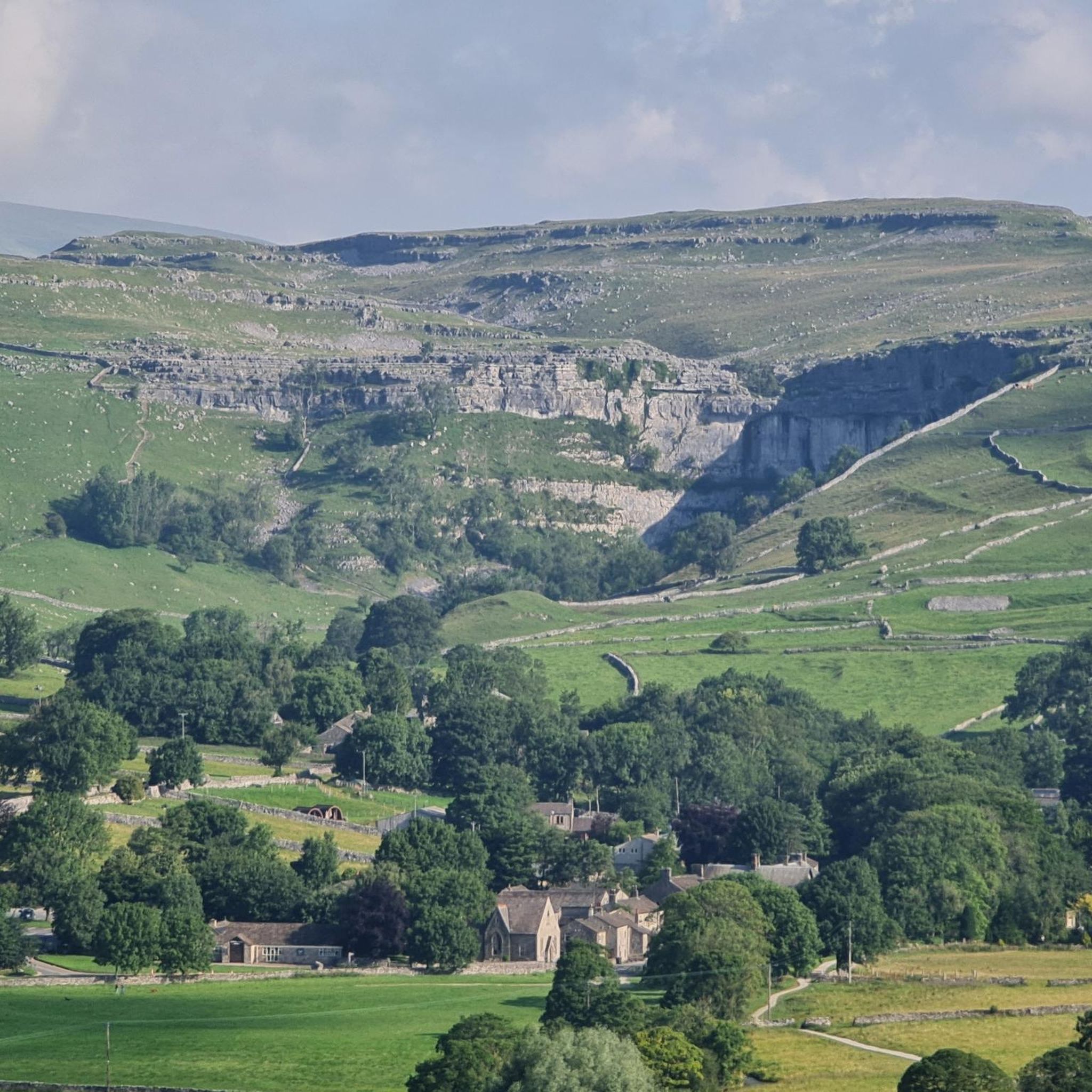
Limestone Pavement at Malham Cove
Highlight • Natural Monument
Tip by

Sharp Haw Summit
Highlight • Viewpoint
Tip by

Sign up now to discover places like this
Get recommendations on the best single tracks, peaks, & plenty of other exciting outdoor places.
Sign up for free
Weets Top
Highlight • Summit
Tip by

Crookrise Trig Point
Highlight • Summit
Tip by
Sheriff Hill
Highlight • Natural
Tip by

Sign up for free to discover even more peaks around Otterburn.
Sign up for free
Already have an account?
Start today with a free account
Your next adventure awaits.
Login or Signup

Tips from the Community


When hiking from the reservoir side, the trig pillar is located off the main path over the side of the wall accessed via a stile
0
0


There is a good moorland path that leads from Rylstone Cross right through to Embsay reservoir which makes for great fell running - it's rocky in parts, muddy in others and always up or down. The highlight and a great goal for a run is the trig point set in huge boulders on the summit of Crookrise
0
0

Where the scene in Harry Potter was filmed where Harry and Hermione sat in the Deathly Hallows. Harry & Hermione set up camp in a tent on the Limestone Pavement at the top of Malham Cove, scenes from the film feature views across Malhamdale including the view to Cawden and down to Malham Village and Kirkby Malham. There is amazing views from this point over the scarred landscape. Malham Cove is a 70m (230ft) high curved crag of carboniferous limestone formed after the last ice age. Meltwater, particularly from Malham Tarn, cut back the cove as it fell over the edge as a waterfall. This erosion took place more actively at the lip of the fall, hence the curved shape. The cove was formed by glaciers that plucked rock from the cliff face and carried it away, and by meltwater that eroded the cliff face after the glaciers melted. The top of the cove is a limestone pavement with a distinctive pattern of limestone blocks called clints and fissures called grykes. The grykes have a more humid and warmer microclimate than the pavement, which supports different plant life. The top of the limestone has dry, stony conditions that support plants like Rock Rose and Thyme. Malham Cove once had a waterfall that was larger than Niagara Falls. The last time water flowed over the waterfall was in the 19th century, until extreme rain in 2015. Malham Cove is a short walk from the village of Malham, and is popular with rock climbers. Malham Cove has been featured in several films and TV shows, including Wuthering Heights, the previously mentioned Harry Potter and the Deathly Hallows, and The Trip.
1
0

Malham Cove is a large curved limestone formation a short walk from the village of Malham. It was formed by a waterfall carrying meltwater from glaciers at the end of the last Ice Age. Easy access to the cove from Malham and there are steps to the side of the cove which allow you to climb to the top. Careful very slippery at the top when on the limestone pavement in wet conditions.
1
0
There's a good trail on the ground either from Flasby (the more interesting route) or Skipton side, and a rocky summit with a trig point - the perfect destination for a fell run
0
0
The 70 metre (230ft) high, gently curving cliff of white limestone is a Yorkshire Dales gem. It has some unique and rare limestone formations at the top of the cliff. You may recognise scenes from Harry Potter and The Deathly Hallows which featured the unique limestone pavement and views down to Malham Village and Kirkby Malham.
1
0
Frequently Asked Questions
What kind of mountain peaks can I expect to find around Otterburn?
Around Otterburn, you'll discover a landscape of rolling hills and expansive moorlands rather than towering mountain peaks. The area is part of the broader Cheviot Hills and Redesdale Valley, offering significant high points and features like Blackman's Law and Padon Hill, which provide panoramic views and opportunities for outdoor exploration.
Are there any historically significant hills or features near Otterburn?
Yes, Padon Hill is particularly rich in history. It features an Iron Age hill fort and a cairn commemorating a wedding anniversary and a Presbyterian preacher. Historically, it was a strategic location during the Battle of Otterburn in 1388. Local folklore also suggests the Fairy Queen Mab resides there, adding to its intrigue.
What are the best places for panoramic views in the Otterburn area?
For excellent panoramic views of the surrounding Redesdale landscape, consider visiting Blackman's Law. Its trig point marks a high elevation, typical of the Cheviot Hills, offering satisfying vistas. Padon Hill also provides broad views, especially given its historical significance.
What outdoor activities can I do in the Cheviot Hills and Redesdale Valley near Otterburn?
The Cheviot Hills and Redesdale Valley, which encompass Otterburn, offer extensive opportunities for outdoor activities. You can enjoy hiking, cycling, and wildlife watching across vast open spaces. The network of trails provides rewarding panoramic views and a chance to experience the wild beauty of Northumberland. For specific routes, you can explore Road Cycling Routes around Otterburn, Running Trails around Otterburn, or Gravel biking around Otterburn.
Is the Otterburn area suitable for nature lovers and wildlife spotting?
Absolutely. The serene countryside of the Cheviot Hills and Redesdale Valley is a haven for nature lovers. The unspoiled landscapes offer opportunities to spot red squirrels, deer, and various bird species, making it an ideal location for wildlife observation.
Are there family-friendly walking options around Otterburn?
The rolling hills and moorlands of the Redesdale Valley offer many trails suitable for families. While specific 'family-friendly' categories aren't listed for individual peaks, the general nature of the Cheviot Hills provides accessible paths for walks, allowing families to enjoy the scenic beauty and historical sites like Padon Hill.
What is the best time of year to visit the hills around Otterburn for hiking?
The region's sweeping moorlands and heather-covered hills are beautiful throughout the warmer months, typically from spring to early autumn. This period generally offers more favorable weather conditions for hiking and enjoying the outdoor scenery. However, the tranquil beauty can be appreciated year-round, with winter offering a different, starker charm.
What makes the Cheviot Hills and Redesdale Valley unique?
The Cheviot Hills and Redesdale Valley are unique for their blend of serene countryside, vast open spaces, and rich historical tapestry. As part of the Northumberland National Park, they offer unspoiled landscapes, diverse wildlife, and a sense of wild tranquility, distinct from more rugged mountain ranges.
Are there any specific landmarks or features to look for when hiking Blackman's Law?
When hiking Blackman's Law, look for the trig point at its summit. This surveying station marks the highest point and is often a satisfying achievement for walkers, signifying a high point in the local terrain and offering potential for good views of the surrounding Redesdale landscape.
Where can I find more information about the Northumberland National Park, which includes the Otterburn area?
For more detailed information about the Northumberland National Park and the Otterburn area within it, you can visit the official website: northumberlandnationalpark.org.uk.
Can I combine a visit to the hills with other sights in the area?
Yes, the hills around Otterburn are well-suited for combining with other local attractions. For example, a walk up Padon Hill can be paired with exploring its Iron Age fort and learning about the Battle of Otterburn. The broader Redesdale Valley offers numerous trails that connect various points of interest, allowing for longer, more varied excursions.
Most popular attractions around Otterburn

Get inspired with the komoot mobile app


Explore more
See even more amazing summits around Otterburn with these guides:
