Routes

Planner

Features

Updates

App

Login or Signup

Get the App

Login or Signup

Routes
Hikes
San Bernardino County

San Bernardino National Forest

Routes
Hikes
San Bernardino County

San Bernardino National Forest

The best family-friendly hikes and walks in San Bernardino National Forest

4.7

(384)

6,423

hikers

98

hikes

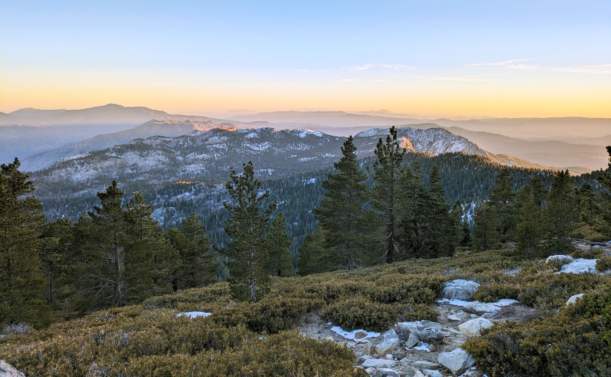
Family friendly hiking trails in San Bernardino National Forest traverse a diverse landscape, from arid desert fringes to alpine environments. The region is characterized by rugged peaks, deep canyons, and extensive forests, with elevations ranging from 2,000 to over 11,500 feet. Hikers can explore varied ecosystems including chaparral, oak woodlands, and mixed conifer forests. This varied terrain provides a wide range of experiences for outdoor enthusiasts.

Best family friendly hiking trails in San Bernardino National Forest

  • The most popular family friendly hiking route is Cougar Crest Trail, an easy 2.7 miles (4.4 km) trail that takes 1 hour 19 minutes to complete. This path offers views overlooking Big Bear Lake and the surrounding mountains.
  • Another top favourite among local hikers is Champion Lodgepole via Castle Rock Trail, a moderate 6.6 miles (10.6 km) path. This route leads through forested areas and offers views of Big Bear Lake.
  • Local hikers also love the Tahquitz Peak via Devil's Slide and Caramba Trail, a 6.6 miles (10.7 km) trail leading through varied mountain terrain, often completed in about 3 hours 36 minutes.
  • Hiking in San Bernardino National Forest is defined by majestic peaks, pristine lakes, and extensive forest trails, offering options for different ability levels. The network includes nearly 100 routes, ranging from easy strolls to more challenging ascents.
  • The routes in San Bernardino National Forest are highly rated by the komoot community with an average score of 4.7 stars from nearly 400 reviews. More than 6,000 hikers have used komoot to explore San Bernardino National Forest's varied terrain.

Last updated: July 8, 2026

5.0

(4)

60

hikers

#1.

San Jacinto Peak and Round Valley Loop

12.2km

03:58

740m

220m

Embark on a dramatic journey through multiple climate zones on the San Jacinto Peak and Round Valley Loop. You'll traverse dense pine forests and meadows in Round Valley, where wildflowers bloom in spring, before ascending to exposed, rocky terrain. The highlight is undoubtedly the summit of San Jacinto Peak, offering spectacular 360-degree panoramic views of the Coachella Valley, Salton Sea, and distant mountain ranges.

This difficult 7.6-mile (12.2 km) hike involves a substantial 2433 feet (741 metres) of elevation gain, taking approximately 3 hours and 58 minutes. Access is typically via the Palm Springs Aerial Tramway, which significantly reduces the initial climb. Remember that a free day-use wilderness permit is required beyond the Long Valley Ranger Station, and high altitude can be a factor, so plan accordingly.

What makes this trail truly notable is the dramatic transition from desert landscapes to alpine wilderness in a single day, especially when using the tram. The area is part of the Mount San Jacinto State Park, a high-elevation wilderness offering a cool escape from the desert heat. Keep an eye out for wildlife like mule deer and mountain chickadees, and appreciate the historical significance of the CCC-built cabin near the peak.

Navigate with device

Send to Phone

Save

Hard

The San Jacinto Peak via Devil's Slide Trail offers a dramatic ascent into the San Jacinto Wilderness, starting amidst dense pine forests and transitioning to rugged, rocky terrain. You'll navigate numerous switchbacks on the Devil's Slide Trail, eventually reaching Saddle Junction before the final, boulder-strewn push to the 10,834-foot summit. The reward for this difficult 7.5-mile (12.0 km) hike, with its 4221 feet (1286 metres) of elevation gain, is an expansive panorama that can stretch all the way to the Pacific Ocean and Catalina Island.

To tackle this approximately 4-hour and 30-minute journey, you'll need a day-use permit from the Idyllwild Ranger Station, especially if you're hiking on a weekend between Memorial Day and Labor Day when permits for the Devil's Slide Trail are limited. Parking at Humber Park also requires an Adventure Pass. Always check for seasonal conditions, as snow and ice can persist at higher elevations, making winter hiking on San Jacinto Peak via Devil's Slide Trail a different challenge.

This route is a significant access point into the San Jacinto Wilderness from Idyllwild, offering a prime way to experience Southern California's alpine beauty. Along the way, you'll intersect with the iconic Pacific Crest Trail, and near the summit, an emergency hut provides shelter. It's considered a good first major mountain for those with solid fitness, showcasing a unique blend of forest, meadows, and dramatic granite topography.

Hard
guide_signup
Let us show you the way with the komoot mobile app
With a free komoot account, you can easily find, customize, and navigate endless outdoor adventures.

Sign up for free

4.0

(1)

8

hikers

Embark on a moderate hike along the Champion Lodgepole via Castle Rock Trail, a 6.6 miles (10.6 km) route that takes about 3 hours and 10 minutes to complete. You will gain 1025 feet (312 metres) in elevation, starting with a climb to Castle Rock. From this vantage point, you can enjoy wide views of Big Bear Lake and the surrounding mountains. The path then winds through towering evergreen trees and past large granite boulders, leading you to the majestic Champion Lodgepole Pine, a truly ancient tree.

Be ready for a steep initial climb to Castle Rock, where some boulder sections can be tricky to navigate. Parking at the trailhead is limited, so plan to arrive early, especially if you are hiking during peak times. If you visit in winter, expect significantly more challenging conditions due to snow and ice, and be sure to bring specialized gear like micro spikes and trekking poles.

This popular trail is nestled within the San Bernardino National Forest, offering a diverse experience with several natural landmarks. The highlight is undoubtedly the Champion Lodgepole Pine, recognized as one of California's largest and oldest lodgepole pines. You also have the option to extend your hike further to explore the tranquil Bluff Lake Reserve, adding more to your day in this scenic area.

Moderate

8

hikers

4.37km

01:19

240m

0m

Embark on the Cougar Crest Trail, an easy hiking route that guides you through varied scenery in the San Bernardino National Forest. You will wander through shaded forests of pine and oak, which gradually give way to more open areas offering expansive views of Big Bear Lake and the surrounding mountains. This out-and-back trail covers 2.7 miles (4.4 km) with an elevation gain of 798 feet (243 metres), typically taking about 1 hour and 19 minutes to complete.

When planning your visit, be aware that an Adventure Pass is often necessary for parking directly at the Cougar Crest Trailhead. If you prefer not to purchase a pass, you can find free parking at the nearby Big Bear Discovery Center. From there, it's just a short walk to reach the trailhead and begin your hike. Consider starting your adventure earlier in the day to enjoy cooler temperatures and fewer crowds.

The Cougar Crest Trail offers more than just scenic views; it also provides a unique connection to the legendary Pacific Crest Trail (PCT). As you hike, you will encounter the point where the two trails intersect, giving you a small taste of this epic long-distance route. This makes the trail a great option for those curious about the PCT or looking for a well-maintained path with a notable connection.

Easy

Embark on a journey through the San Jacinto Wilderness on the Tahquitz Peak via Devil's Slide and Caramba Trail, a moderate hike that delivers stunning vistas. The route begins with a vigorous climb up the Devil's Slide Trail, winding through shaded forests and past prominent granite formations like Lily Rock. Further along the Caramba Trail, you'll find yourself amidst tranquil open pine forests and grassy meadows, before the final rocky ascent to Tahquitz Peak, offering sweeping panoramic views.

To tackle this 6.7-mile (10.7 km) route with its 2364 feet (720 metres) of elevation gain, plan for about 3 hours and 36 minutes of hiking. Remember that a free wilderness permit is required, and an Adventure Pass is needed for parking at Humber Park. Due to the Devil's Slide Trail Idyllwild popularity, especially on summer weekends, a quota system for permits is in place, so secure yours in advance.

The highlight of this trail is undoubtedly the historic Tahquitz Peak Fire Lookout at the summit, which has been continuously operated for over 77 years and provides a unique perspective on the surrounding mountains and valleys. The trail also intersects with the Pacific Crest Trail at Saddle Junction, a significant meeting point for hikers. This top-rated day hike offers a blend of challenging terrain and rewarding scenery, making it a must-do for experienced hikers in the Idyllwild area.

Moderate
Sign up for free to see 94 more hikes in San Bernardino National Forest.

Get access to more routes and recommendations from other explorers.

Sign up for free

Already have an account?

Our route recommendations are based on thousands of hikes, rides, and runs completed by other people on komoot.

Start today with a free account

Your next adventure awaits.

Login or Signup

Popular around San Bernardino National Forest

Pacific Crest Trail from Mexico to Canada – 4,200 kilometres of wilderness

Climbing Mount San Jacinto on the Deer Springs Trail

Other adventures in San Bernardino National Forest

Pacific Crest Trail from Mexico to Canada – 4,200 kilometres of wilderness

Hiking Collection by

Caro "Bandit"

Tips from the Community

Quentin
October 1, 2025, View of Big Bear Lake and San Gorgonio Wilderness

Very nice views but a bit dusty

0

0

Sofía_Ibáñez
November 29, 2023, Round Valley

Round Valley is one of the designated campgrounds at San Jacinto State Park. It is a primitive camp, with no other amenities than a couple of cabin toilets and a fountain (the water needs to be purified). The area is very large and there are several plots to choose from, spread across a beautiful coniferous forest through which a crystalline stream runs.

Translated by Google

0

0

Alex
November 27, 2023, Wellman Divide

Wellman Divide is at a trail junction at 9700 feet above sea level. From here you can choose to go... South on Wellman's Cienaga Trail... East on Round Valley trail, taking you back to the restaurant... Or North on Peak Trail to the San Jacinto Summit.

0

0

With 10,883 feet, Mount San Jacinto is the highest peak in the San Jacinto Mountains. There is a network of hiking trails around the summit and the San Jacinto State Park itself. If the weather turns for the worst, you can find shelter in a little hut close to the summit. You can either take a hike from Idyllwild on the west side of the mountain or Palm Springs on the east side. There is also an aerial tramway you can use to get into the San Jacinto Wilderness. If you feel adventurous, you can cross the mountain range using the Pacific Crest Trail.

0

0

Zachary
September 19, 2023, Cougar Crest Trailhead

If you park in the parking lot you need to purchase and display an Adventure Pass, but you may be able to park a short ways down the road without one. The best views from this trailhead are at Bertha Peak.

1

1

Zachary
September 7, 2023, Bluff Lake Reserve

The lake is a pristine mountain marsh that sits at 7,600 ft above sea level. The trail around the lake is easy and surrounded by boulders and towering pines.

0

0

Zachary
September 7, 2023, Castle Rock

Castle Rock is a boulder pile that makes a popular destination for its scenic views that look out upon Big Bear Lake and the surrounding mountains.

0

0

At the junction to Taquitz Valley, you will find some nice flat spots that are protected when the winds are howling along the ridge. There is also a creek which serves as a good water source.

4

0

Frequently Asked Questions

How many family-friendly hiking trails are available in San Bernardino National Forest?

The San Bernardino National Forest offers a wide variety of hiking experiences. For families, there are over 80 trails categorized as easy or moderate, providing plenty of options for all ages and skill levels.

What kind of scenery can we expect on family hikes in San Bernardino National Forest?

You can expect incredibly diverse scenery, from rugged peaks and deep canyons to lush forests of pine, fir, oak, and juniper. Many trails offer panoramic vistas, especially from higher elevations, and in spring, you might even catch vibrant wildflower displays.

Are there any trails with waterfalls or interesting natural features suitable for families?

Yes, the forest is home to several beautiful waterfalls, particularly after rainfall, such as Bonita Falls and Big Falls. You can also find Seely Creek Falls near the unique Heart Rock formation, which is often a popular spot for families. Additionally, Castle Rock offers great views over Big Bear Lake.

What do other hikers say about the family-friendly trails in San Bernardino National Forest?

The komoot community highly rates the trails in San Bernardino National Forest, with an average score of 4.7 stars from over 370 reviews. Hikers often praise the stunning views, the variety of terrain, and the well-maintained paths that make for enjoyable family outings.

Are there any easy loop trails that are good for families?

While many trails offer out-and-back options, you can find routes like the Desert View Trail Loop, which is a shorter 1.7-mile path providing panoramic views from Mount San Jacinto State Park. For a moderate option with great views, consider the Cougar Crest Trail, which offers stunning vistas of Big Bear Lake.

What are some notable landmarks or points of interest we can visit on a family hike?

Many trails lead to or pass by significant landmarks. For example, the Champion Lodgepole via Castle Rock Trail takes you past the impressive Castle Rock. You can also find trails leading to Bertha Peak, which provides wonderful views overlooking Big Bear Lake.

What is the best time of year to go hiking with family in San Bernardino National Forest?

The best time for family hiking generally depends on the elevation. Spring and fall offer pleasant temperatures and beautiful scenery, with wildflowers in spring and colorful foliage in fall. Higher elevations can be enjoyed in summer, while lower trails are accessible year-round, though summer can be hot and winter may bring snow to higher areas.

Are there any specific trails that offer expansive views for families?

Absolutely. The Cougar Crest Trail is an excellent choice, providing wonderful views overlooking Big Bear Lake and the surrounding mountains. For a more challenging but rewarding family adventure, the Tahquitz Peak via Devil's Slide and Caramba Trail offers views extending all the way to the Salton Sea from its seasonal fire lookout.

What kind of wildlife might we encounter on family hikes?

The diverse habitats of San Bernardino National Forest support a rich array of wildlife. Lucky hikers might spot mule deer, various bird species, and occasionally even black bears or bighorn sheep. Always remember to observe wildlife from a distance and never feed animals.

Are there any easy trails that are relatively short for younger children?

Yes, there are many easy trails suitable for younger children. While specific short routes vary, the forest offers numerous options for quick strolls and gentle walks. Look for trails around Big Bear Lake or those designated as 'easy' on komoot for shorter, less strenuous options.

Most popular routes in San Bernardino National Forest

Hiking in San Bernardino National Forest

Most popular attractions in San Bernardino National Forest

Places to see

Store rating

Get inspired with the komoot mobile app

With a free komoot account, you can easily find, customize, and navigate endless outdoor adventures.

or

Join komoot Now

Store rating

Explore more

Browse the best Hikes in other regions.

San Bernadino MountainsChino Hills State ParkBig Bear CitySand To Snow National MonumentBighorn Mountain WildernessCucamonga WildernessSand To Snow National MonumentSand To Snow National MonumentBig Bear LakeWildwood Canyon State ParkChino HillsWhipple Mountains WildernessKingston Range WildernessYucaipaMojave River Forks Regional ParkRancho CucamongaFontanaWrightwoodCrestlineMorongo ValleyYucca Valley

Nearby adventure guides

Things to Do around Oak Glen

background

Get ready to conquer new peaks

Sign up for Free

Explore
RoutesRoute plannerFeaturesHikesMTB TrailsRoad cycling routesBikepackingSitemap
Download the app
Follow Us on Socials

© komoot GmbH

Privacy Policy