Chiricahua National Monument Wilderness
Chiricahua National Monument Wilderness
Top 10 Natural Monuments in Chiricahua National Monument Wilderness
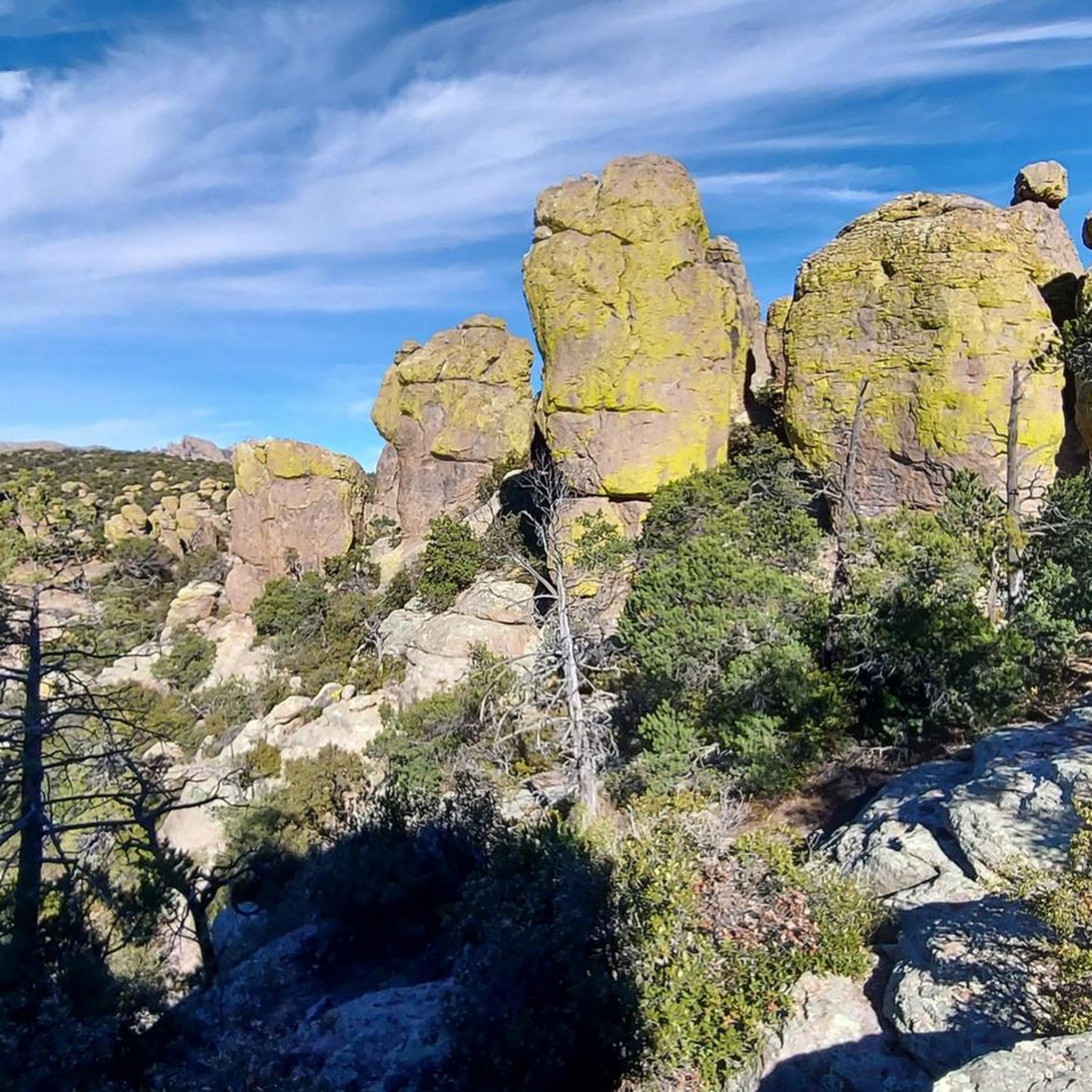
Best natural monuments in Chiricahua National Monument Wilderness feature extraordinary volcanic rock formations, often referred to as a "Wonderland of Rocks." This southeastern Arizona wilderness protects a unique geological landscape shaped by millions of years of erosion. The distinctive natural monuments are primarily composed of rhyolitic tuff, sculpted into towering rock spires, massive stone columns, and balanced rocks. This area offers a chance to explore a diverse ecosystem and unique geological features.
Best natural monuments in Chiricahua National Monument Wilderness
…Last updated: July 26, 2026
Ed Riggs Trail
Highlight (Segment) • Trail
Tip by

Echo Canyon Trail
Highlight • Trail
Tip by
Sign up now to discover places like this
Get recommendations on the best single tracks, peaks, & plenty of other exciting outdoor places.
Sign up for free
Big Balanced Rock Trail
Highlight (Segment) • Natural Monument
Tip by
Sarah Deming Trail
Highlight (Segment) • Trail
Tip by
Upper Sarah Demming Trail
Highlight • Trail
Tip by
Sign up for free to discover even more natural monuments in Chiricahua National Monument Wilderness.
Sign up for free
Already have an account?
Start today with a free account
Your next adventure awaits.
Login or Signup
Popular around Chiricahua National Monument Wilderness
Tips from the Community

Certainly the busiest place in the Park, but well worth it.
0
0

Stunning rock spires, some of them topped by gravity defying balanced rocks
3
0
From the junction of the Big Balanced Rock Trail and Heart of Rocks Loop, the 1.6 mile Sarah Deming Trail heads east through the maze of rocks and descends into Sarah Deming Canyon. In several places the pathways squeeze through the rocks. After descending into Sarah Deming Canyon, the trail hugs the edge of Rhyolite Canyon to meet up with the Upper and Lower Rhyolite Canyon Trails, where views begin to open up of the formations in the canyon below, as well as up to Sugarloaf Mountain. Here, either follow the Upper Rhyolite Trail right to the Echo Canyon Parking Area via the Echo Canyon Trail, or turn left on the Lower Rhyolite Trail to the visitor center.
1
0
The Big Balanced Rock Trail begins at the intersection of the Mushroom Rock Trail and the trail to Inspiration Point. All along the trail, views open up of the Chiricahua Mountains, craggy hills, and the plains of Arizona, as well as a several rock spires. Some of them are eroded in gravity-defying shapes, several seem to be balancing rocks, until, after about 1 mile, the eponymous Big Balanced Rock appears on the left. This is impossible to miss; the rock is massive and square, about a thousand tons, 26 foot tall massive rock perfectly balanced on a tiny eroded base about a foot wide. You are now in the Heart of Rocks area, among many very impressive rock spires. A short distance later comes the junction with the Heart of Rocks Loop and Sarah Deming Trail, the latter looping back to the parking area.
2
0
The trail begins about 0.2 miles below and about halfway between the Echo Canyon and Massai Point parking areas. Ever descending, the trail works its way along the side of the valley for the next 0.7 miles. This section of the trail is in the forest; the coolness of the trees is welcome in the heat of the day. As the trail approaches the one mile point, views begin to open up of spires. While it's only a taste of what's to come if you continue beyond the end of the Ed Riggs Trail, it's still very impressive. The trail ends at the junction with the Hailstone Trail and the Mushroom Rock Trail; continue on either for a short or longer loop.
3
0
Impressive rock work from the 1930s Civil Conservation Corps trail builders along the best viewpoints leading from the Heart of Rocks and Big Balanced Rock trails down west into the Rhyolite canyon toward the visitor center.
1
0
Frequently Asked Questions
What are some of the most impressive rock formations to see in Chiricahua National Monument Wilderness?
The monument is a 'Wonderland of Rocks' with many unique formations. Don't miss the Big Balanced Rock, a massive square rock perfectly balanced on a narrow base. The Heart of Rocks area also features imaginative formations like Duck on a Rock, Punch & Judy, and the Kissing Stones.
Are there any trails that offer panoramic views of the Chiricahua National Monument Wilderness?
Yes, Echo Canyon Trail offers stunning views of rock spires and canyons. For expansive 360-degree vistas, Massai Point, accessible via the Bonita Canyon Scenic Drive, provides panoramic views of the rock valleys, Sugarloaf Mountain, and distant mountain ranges.
What kind of unique geological features can I expect to see in Chiricahua National Monument Wilderness?
The wilderness is renowned for its extraordinary volcanic rock formations, primarily composed of rhyolitic tuff. Millions of years of erosion have sculpted this material into towering rock spires, massive stone columns, craggy grottoes, and precariously balanced rocks, often referred to as hoodoos. It truly feels like a 'magical stone forest'.
What are some family-friendly activities or easy hikes in Chiricahua National Monument Wilderness?
For an easy overview of the wilderness and its geology, the Massai Nature Trail at Massai Point is a great option. Additionally, several easy hikes are available, such as the Echo Canyon Loop Trail or the Silver Spur Meadow Trail, which are suitable for families.
What is the best time of year to visit Chiricahua National Monument Wilderness?
The Chiricahua National Monument Wilderness can be visited year-round, but spring and fall generally offer the most pleasant weather for hiking and exploring. Summers can be hot, while winters are mild, though higher elevations may see occasional snow.
What kind of wildlife can be found in the Chiricahua National Monument Wilderness?
As a 'sky island,' the Chiricahua Mountains are a unique crossroads for plants and animals from four different ecosystems. You might spot diverse animal life such as peccaries, coatis, javelinas, and black bears. It's also a paradise for birdwatchers, with species like coppery-tailed trogons, sulphur-bellied flycatchers, and Mexican chickadees.
Are there any historical or cultural aspects to the Chiricahua National Monument Wilderness?
Yes, the area holds significant cultural history. It was known to the Chiricahua Apache Nation as 'Land of the Standing-Up Rocks' and is associated with Apache leaders like Cochise and Geronimo. The Civilian Conservation Corps also built many of the monument's trails in the 1930s, showcasing impressive rock work.
Are there any loop trails for hiking in the monument?
Yes, the Heart of Rocks Loop is a challenging 7.3-mile round trip that offers an immersive experience among the 'rock cities.' The Echo Canyon Loop Trail is a moderate 3.3-mile hike that winds among impressive pinnacles. You can find more hiking options, including loops, in the Hiking in Chiricahua National Monument Wilderness guide.
What are some of the longer or more challenging trails for experienced hikers?
For a more challenging experience, consider the 7.3-mile Heart of Rocks Loop. The Ed Riggs Trail, while starting with a descent, can be combined with other trails for a longer loop. A challenging 0.9-mile hike also leads to the summit of Sugarloaf Mountain, offering expansive views.
Is there an entrance fee or permit required to visit Chiricahua National Monument Wilderness?
Chiricahua National Monument does not charge an entrance fee. However, specific activities or areas within the monument might have their own regulations. For the most current information on permits or any potential fees, it's always best to check the official National Park Service website for Chiricahua National Monument at nps.gov/chir.
What do visitors enjoy most about the natural monuments in Chiricahua National Monument Wilderness?
Visitors are consistently amazed by the unique geology and the sheer scale of the gravity-defying rock formations. The monument offers exceptional hiking opportunities for all levels, from easy strolls to strenuous treks, allowing for an immersive experience in this 'Wonderland of Rocks.' The diverse ecosystems and dark skies for stargazing are also highly appreciated.
Can I see any impressive rock formations from the road or with minimal hiking?
Yes, the 8-mile Bonita Canyon Scenic Drive leads to Massai Point, offering panoramic views without extensive hiking. Along the drive, you'll get glimpses of the unique rock formations. The Massai Nature Trail at Massai Point is also an easy, short walk that provides an introduction to the monument's geology.
Most popular routes in Chiricahua National Monument Wilderness
Most popular attractions in Chiricahua National Monument Wilderness

Get inspired with the komoot mobile app


Explore more
Extend your search for the best caves by checking out these guides of the top ones in Chiricahua National Monument Wilderness:
