Attractions and Places To See in the Purcell Mountains - Top 20
Best attractions and places to see in the Purcell Mountains, an interior range in southeastern British Columbia, include towering peaks, pristine wilderness areas, and historic sites. This subrange of the Columbia Mountains is situated between the Rocky Mountain Trench and Kootenay Lake. The region is characterized by high glaciated mountains, alpine lakes, wetlands, and old-growth forests. It serves as a habitat for diverse plant and animal communities.
Best attractions and places to see in the Purcell Mountains
- The most popular attractions is Kootenai Falls Swinging Bridge, a bridge that spans the width of Kootenai Falls. This bridge offers views of the falls and provides access to both banks of the river.
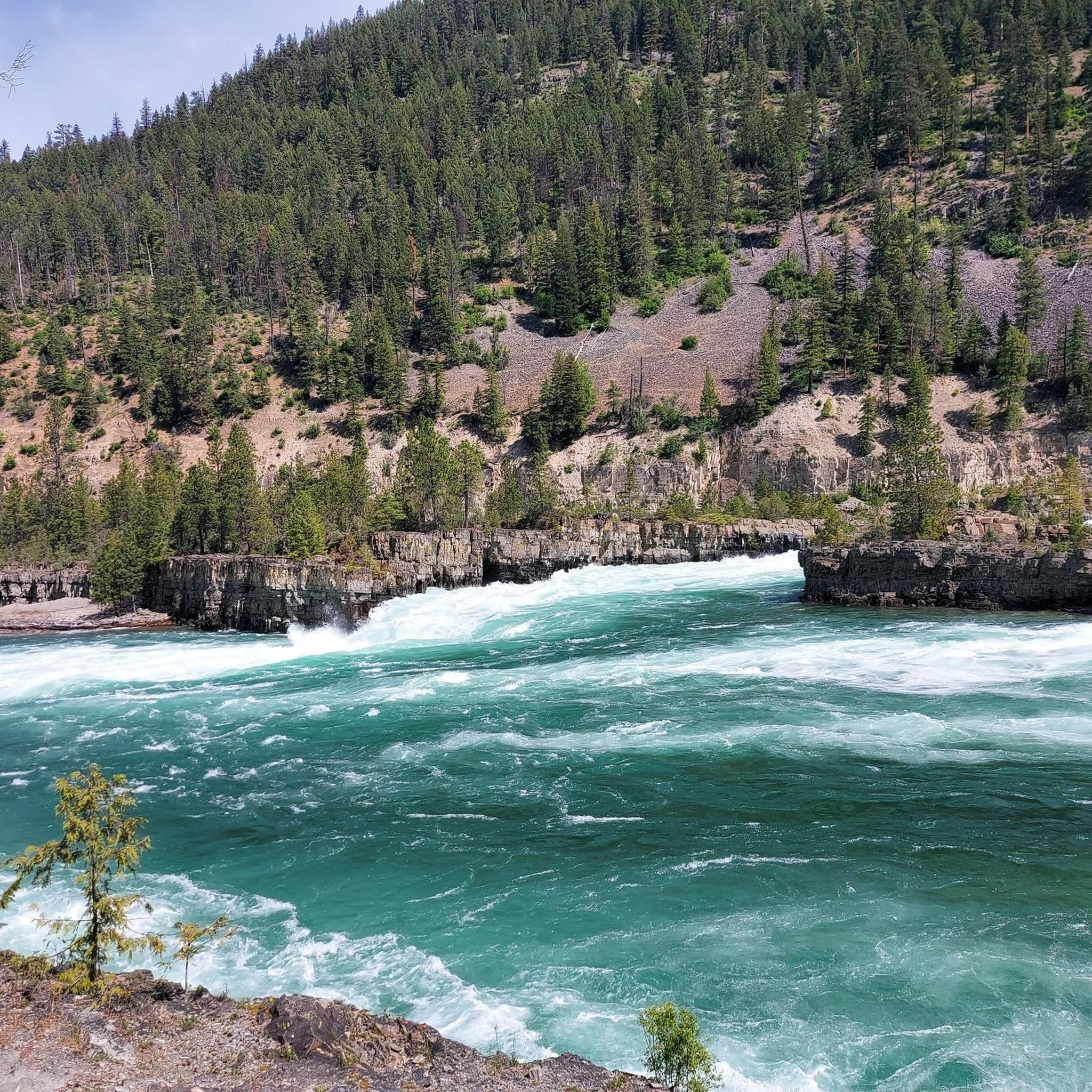
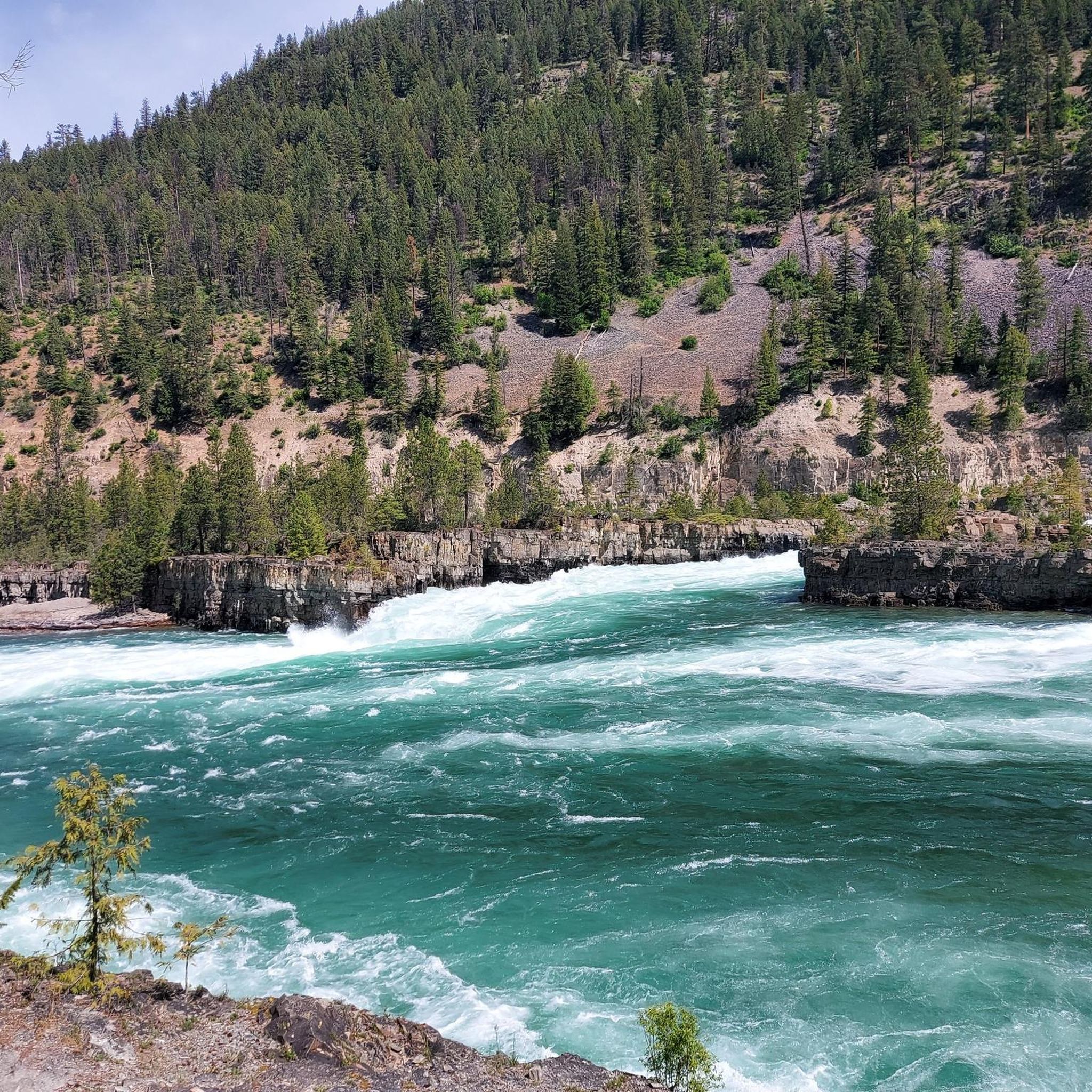
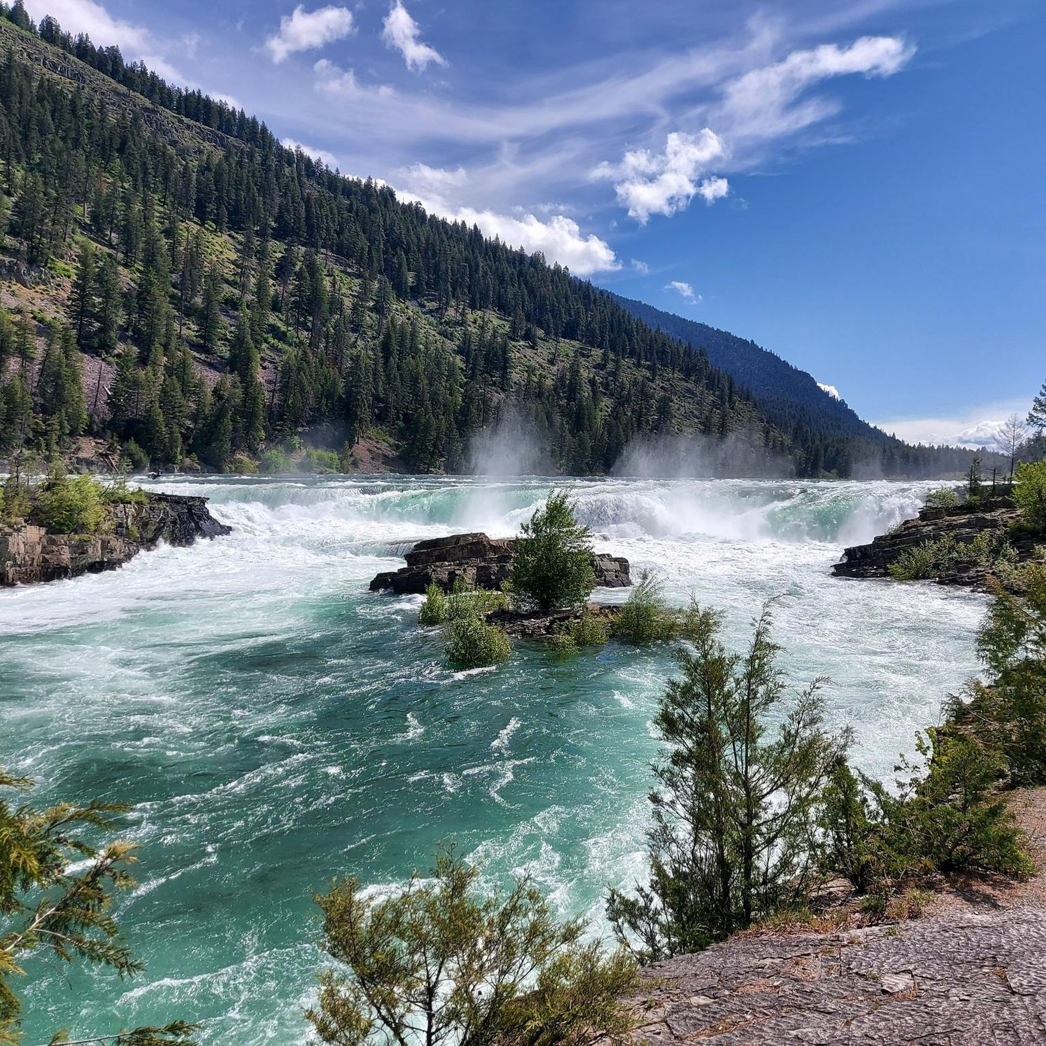
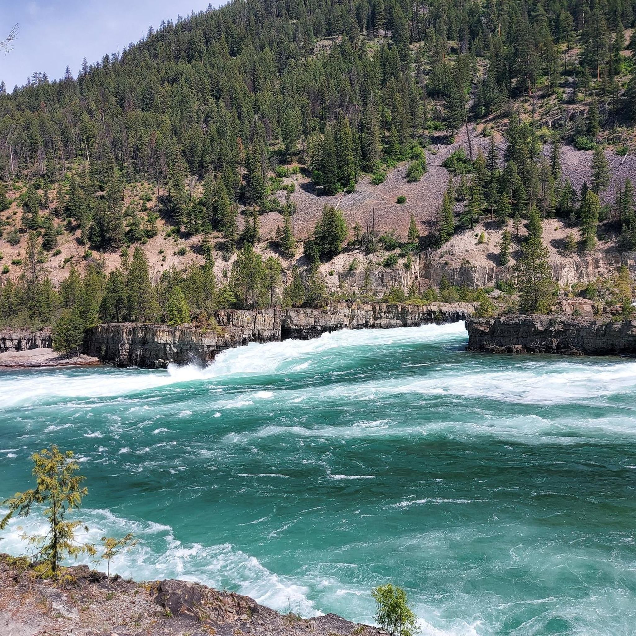
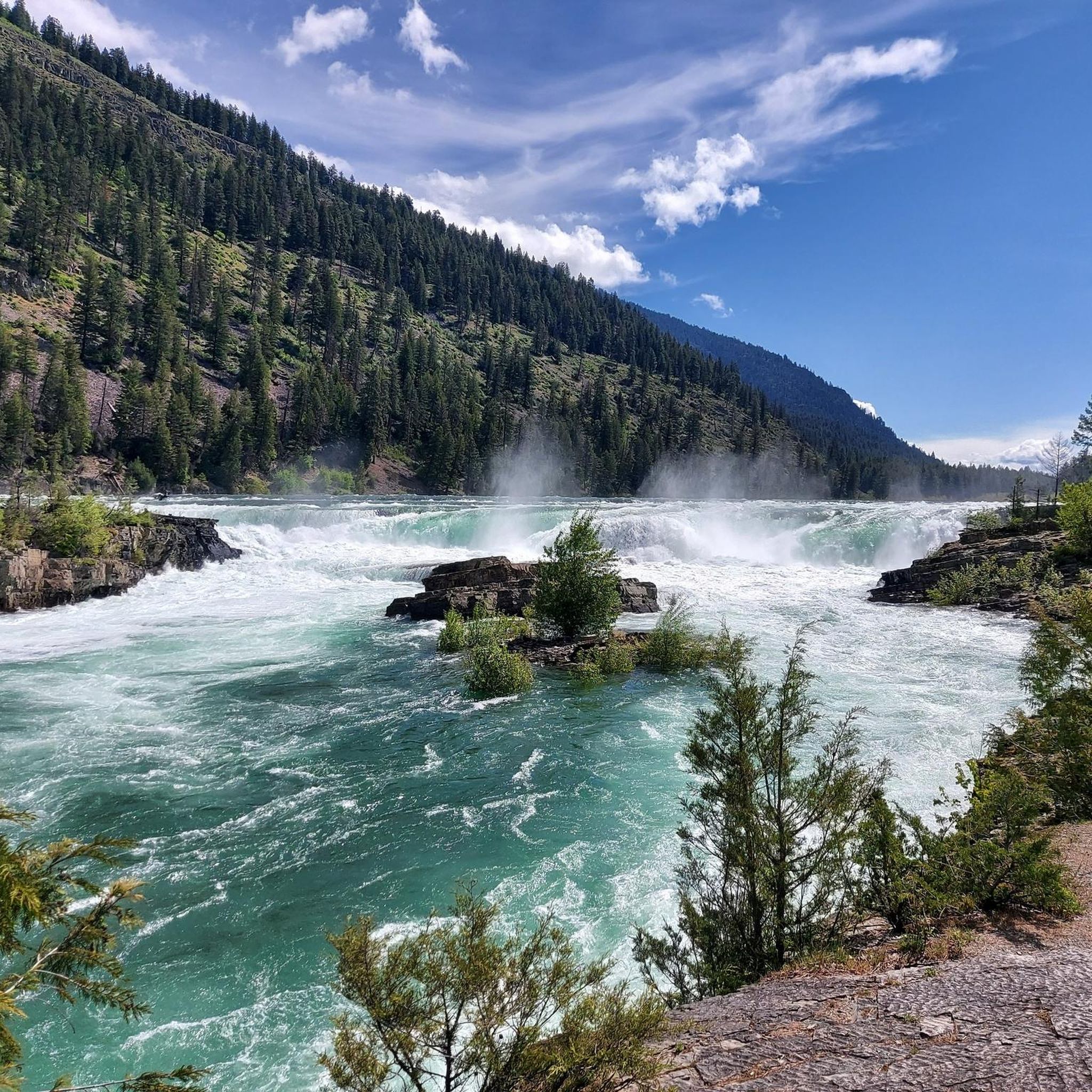
- Another must-see spot is Kootenai Falls, a waterfall. It is the largest undammed waterfall in Montana and holds sacred significance for the Kootenai people.
- Visitors also love Cedar Lake Picnic Area, a lake popular for swimming and picnicking. The area offers benches and facilities for visitors.
- Purcell Mountains is known for towering peaks, pristine wilderness areas, and historic sites. The region offers diverse opportunities for outdoor activities and cultural exploration.
- The attractions in the Purcell Mountains are appreciated by the komoot community, with 11 upvotes and 17 photos shared.
Last updated: October 11, 2026
Canyon Creek Gorge
Highlight • Gorge
In the evening hours you meet other hikers and joggers. Otherwise is a quiet corner!
Directions:
Parking is limited and the roads are full of potholes!
Don't forget mosquito repellent!
And definitely there are goats to see! Pumas and bears are rare, but it has happened!
Translated by Google •
Tip by

Cedar Lake Picnic Area
Highlight • Lake
To pause the place is also very good because we have found no other place to rest. There are also benches and a clean toilet.
Translated by Google •
Tip by

Sign up now to discover places like this
Get recommendations on the best single tracks, peaks, & plenty of other exciting outdoor places.
Kootenai Falls Swinging Bridge
Highlight (Segment) • Bridge
Tip by

Gray Creek Pass
Highlight (Segment) • Mountain Pass
* Heading East: Average of 11.1% grade for 12+km from the start of this highlight, to the Pass. In the last 4km or so, you will find grades in the high teens and low 20's.
* Heading West: Average of 3.1% grade for 30+km from the start of this highlight, to the Pass. Note: Although lower grade, the road can be very rugged and technically difficult, especially with a loaded bike. The last 3km or so, you will find grades in the low to mid teens.
Complete this ride fully equipped. There are no supplies, limited water and expect no cell service. Bring a GPS tracker in case of emergency.
The route follows active FSR's with limited visibility, USE CAUTION along the way. Watch for all vehicles, especially heavily laden logging trucks, give them much extra room to pass.
The Gray Creek Pass road is normally closed to vehicles through the winter, opening as late as mid July. Late snow and the occasional washout can delay the annual opening. Cyclists can often pass through these obstacles but do so at their own risk. Visit the Gray Creek Store’s website for the latest road conditions: graycreekstore.com/general-store/news
Tip by

Lower Bugaboo Falls
Highlight • Waterfall
Tip by

Kootenai Falls
Highlight • Waterfall
Tip by
View of St. Mary River from the bridge
Highlight • River
The views from the bridge are breathtaking!
Tip by

Kootenai Falls Trailhead
Highlight • Parking
Tip by
Kootenay Bay Terminal
Highlight • Rest Area
Translated by Google •
Tip by

Perry Creek Falls
Highlight • Waterfall
Tip by

Sign up for free to discover even more attractions in the Purcell Mountains.
Already have an account?
Start today with a free account
Your next adventure awaits.
Popular around Purcell Mountains

Pacific Northwest National Scenic Trail — From Alpine to Alava through the untamed Northwest

Cross Canada Ride — heading east for 6,800km

BC Epic 1000
Hiking in the Purcell Mountains
Road Cycling Routes in the Purcell Mountains
Cycling in the Purcell Mountains
MTB Trails in the Purcell Mountains
Running Trails in the Purcell Mountains
Gravel biking in the Purcell Mountains


Tips from the Community

Here, the North Star Rail Trail crosses the St. Mary River. The river flows from St. Mary Lake through forested valleys toward the Kootenay River, and it's a well-known hub for water sports, from whitewater paddling to fly fishing. The views from the bridge are breathtaking!
0
0

At the end of the Perry Creek Trail in East Kootenay, you reach Perry Creek Falls, where the creek drops over a rugged rock face into a narrow gorge. The viewpoint is set slightly back, so you’re looking across at the falls rather than right beside them, but you still get a clear view of the cascade and the surrounding forest. After following the creek the whole way, this feels like a natural turnaround point and the highlight of the hike.
0
0

This powerful and towering waterfall can only safely be viewed from afar, either as you look down at it from a canyon wall or from a sandy spot down river.
0
0

The free ferry between Kootenay Bay and Balfour is one of the most scenic ferry rides in Canada, with stunning views of Kootenay Lake and the surrounding mountains.
3
0
The Kootenay Bay Terminal is a major shipping point in the Kootenay region of British Columbia, Canada, primarily used for ferry service between Kootenay Bay and Balfour. Here is information about the terminal and some scenic spots you can explore in the area:
3
0

Gray Creek Pass is part of the Great Trail and also part of the BC Trail & BC Epic 1000. It is tough and rugged, following a forest service road. This price of admission (effort) for this ride is high, but so is the reward. * Heading East: Average of 11.1% grade for 12+km from the start of this highlight, to the Pass. In the last 4km or so, you will find grades in the high teens and low 20's. * Heading West: Average of 3.1% grade for 30+km from the start of this highlight, to the Pass. Note: Although lower grade, the road can be very rugged and technically difficult, especially with a loaded bike. The last 3km or so, you will find grades in the low to mid teens. Complete this ride fully equipped. There are no supplies, limited water and expect no cell service. Bring a GPS tracker in case of emergency. The route follows active FSR's with limited visibility, USE CAUTION along the way. Watch for all vehicles, especially heavily laden logging trucks, give them much extra room to pass. The Gray Creek Pass road is normally closed to vehicles through the winter, opening as late as mid July. Late snow and the occasional washout can delay the annual opening. Cyclists can often pass through these obstacles but do so at their own risk. Visit the Gray Creek Store’s website for the latest road conditions: https://graycreekstore.com/general-store/news
2
0

Impressing water falls dropping over two steps, split by a stone column
1
0

This swinging bridge spans the width of Kootenai Falls, where the Kootenai River loses 300 feet of elevation over just a few hundred yards. The bridge offers good views of the falls and provides access to both banks of the river.
1
0
Frequently Asked Questions
What natural attractions can I explore in the Purcell Mountains?
The Purcell Mountains offer a variety of natural attractions. You can visit Kootenai Falls, the largest undammed waterfall in Montana, or the scenic Lower Bugaboo Falls. For a relaxing experience, Cedar Lake Picnic Area is popular for swimming and picnicking. The region also features expansive areas like the Purcell Wilderness Conservancy Provincial Park, known for its glaciated mountains and alpine lakes, and the Columbia Wetlands, a critical habitat for migratory birds.
Are there any family-friendly attractions in the Purcell Mountains?
Yes, the Purcell Mountains offer several family-friendly options. The Cedar Lake Picnic Area is ideal for families, offering swimming and picnicking facilities. The Kootenai Falls Trailhead provides easy access to the falls and the swinging bridge, making it suitable for all ages. The free Kootenay Lake Ferry also offers a scenic and enjoyable experience for families.
Where can I find the best viewpoints in the Purcell Mountains?
Excellent viewpoints are abundant throughout the Purcell Mountains. The Kootenai Falls Swinging Bridge offers spectacular views of the falls and the river. For those seeking a challenge, Terminator Peak provides rewarding panoramic views. Additionally, the free Kootenay Lake Ferry offers stunning vistas of the lake and surrounding mountains.
What historical or cultural sites can I visit in the Purcell Mountains region?
The Purcell Mountains region is rich in history and culture. It is the traditional homeland of the Ktunaxa First Nation. You can explore Kootenai Falls, which holds sacred significance for the Kootenai people. Fort Steele Heritage Town, established during the Wild Horse Creek gold rush, offers a glimpse into the region's early European settlement. The town of Kimberley also has a history tied to the world's largest lead and zinc mine.
What are some popular hiking trails in the Purcell Mountains?
The Purcell Mountains offer diverse hiking opportunities. For an easy walk, consider the Kootenai Falls and Swinging Bridge Trail. The Lower Bugaboo Falls Trail is another accessible option. For more challenging routes, the Purcell Wilderness Conservancy Provincial Park offers unimproved trails for experienced wilderness travelers. You can find more hiking options in the Easy hikes in the Purcell Mountains guide.
Are there opportunities for cycling in the Purcell Mountains?
Yes, the Purcell Mountains provide excellent opportunities for cycling. You can explore various road cycling routes, such as the Koocanusa Lake loop, or gravel biking adventures like the Wardner Lake Road. For more detailed routes and guides, check out the Road Cycling Routes in the Purcell Mountains and Gravel biking in the Purcell Mountains guides.
What is the best time to visit the Purcell Mountains for outdoor activities?
The best time to visit the Purcell Mountains for outdoor activities generally depends on the activity. Late spring through early autumn (May to October) is ideal for hiking, cycling, and exploring natural attractions like waterfalls and lakes, when trails are clear and weather is milder. Some waterfalls, like Moyie Falls, are best visited in late summer or autumn when water levels are lower for better viewing.
Are there any unique wilderness experiences in the Purcell Mountains?
The Purcell Mountains offer unique wilderness experiences, particularly within the Purcell Wilderness Conservancy Provincial Park, which features high glaciated mountains, alpine lakes, and old-growth forests. The Bugaboos, with their challenging granite spires, are renowned among mountain climbers. For a remote alpine experience, the Purcell Mountain Lodge is accessible by helicopter and offers guided backcountry hiking.
What are the terrain features like for hiking in the Purcell Mountains?
The terrain in the Purcell Mountains varies significantly. You'll find high glaciated mountains, alpine lakes, and wetlands in areas like the Purcell Wilderness Conservancy. Trails can range from easy, well-maintained paths near attractions like Kootenai Falls Swinging Bridge to challenging, unimproved routes with river crossings in more remote wilderness areas. The region also features deep canyons, such as Canyon Creek Gorge.
What towns are located near the Purcell Mountains and what amenities do they offer?
Several towns are situated near the Purcell Mountains, offering various amenities. Invermere is known for its recreational activities. Kimberley, historically a mining town, provides services for visitors. Cranbrook, located nearby, is a larger community that serves as a gateway to the region. These towns typically offer accommodation, cafes, pubs, and other essential services for travelers exploring the mountains.
Are there any hot springs in the Purcell Mountains?
Yes, the Purcell Mountains are home to Dewar Creek Hot Springs, a special natural feature located within the Purcell Wilderness Conservancy Provincial Park. These hot springs offer a unique natural experience for those venturing into the park's remote wilderness.
What is the significance of the Columbia Wetlands in the Purcell Mountains region?
The Columbia Wetlands, situated along the eastern side of the Purcells, are among the longest undeveloped wetlands in North America. They are incredibly significant as a crucial habitat for migratory birds and diverse wildlife, including grizzly bears, mountain caribou, and wolverines, making them a vital ecological area in the region.
Most popular routes in the Purcell Mountains
Most popular attractions in the Purcell Mountains

Get inspired with the komoot mobile app


Explore more
Still not found the Highlight you’re looking for? See guides of the top attractions in other regions:
