The best cycling routes in Bjortjønn Dyrefredningsområde
3.0
(2)
14
riders
5
rides
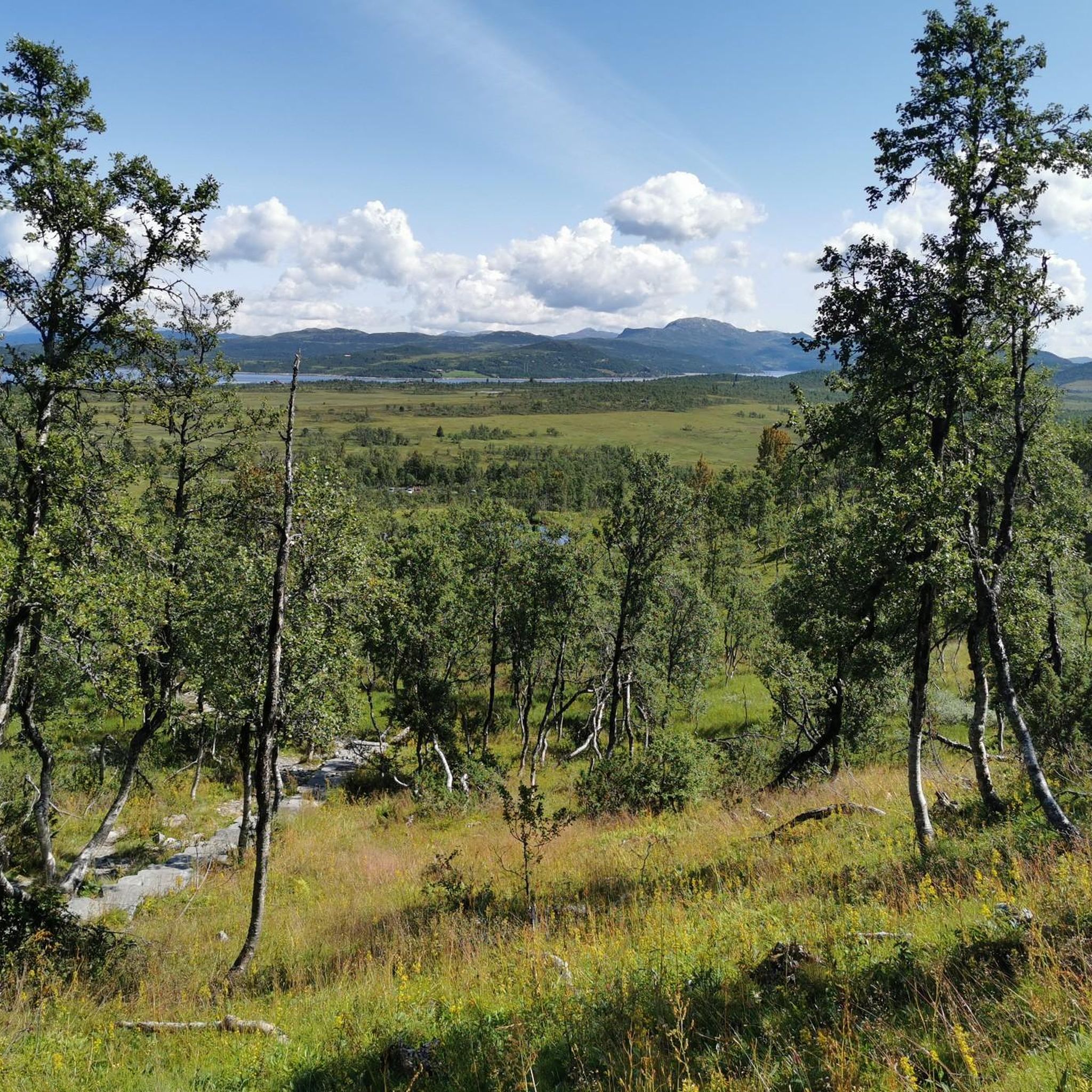
Touring cycling in Bjortjønn Dyrefredningsområde is characterized by a landscape situated at approximately 900 meters above sea level. The region features a relatively flat and marshy terrain, with extensive bogs, numerous tarns, and small lakes. Drier areas include birch forests and scattered smaller hills. While the area is rich in natural features, its marshy and boggy conditions present specific challenges for traditional touring cycling routes.
Best touring cycling routes in Bjortjønn Dyrefredningsområde
- The most popular touring cycling route is Waterfall near Fossli – Velemoen Camping loop from Krossen, a 59.2 miles (95.3 km) trail that takes 6 hours 3 minutes to complete. This difficult route features significant elevation gain.
- Another top favourite among local touring cyclists is Miningsskard – Linuten loop from Tingvoll, a difficult 25.4 miles (40.9 km) path. This route includes varied terrain and notable ascents.
- Local touring cyclists also love the Linuten – Blåbærhaugen loop from Vierli, a 23.8 miles (38.4 km) trail leading through high-altitude landscapes, often completed in about 2 hours 45 minutes.
- Touring cycling in Bjortjønn Dyrefredningsområde is defined by marshy areas, birch forests, and small hills. The available routes offer options for moderate and difficult ability levels.
- The guide includes highly-rated routes that showcase the best of the region's landscape. More than 10 touring cyclists have used komoot to explore Bjortjønn Dyrefredningsområde's varied terrain.
Last updated: October 7, 2026
3.0
(1)
5
riders
37.6km
02:41
510m
510m
Hard bike ride. Very good fitness required. Mostly paved surfaces. Suitable for all skill levels.
16.3km
01:20
190m
190m
Moderate bike ride. Good fitness required. Mostly paved surfaces. Suitable for all skill levels.

3.0
(1)
3
riders
39.4km
03:05
620m
620m
Hard bike ride. Very good fitness required. You may need to push your bike for some segments of this route.
16.9km
01:23
250m
250m
Moderate bike ride. Good fitness required. Mostly paved surfaces. Suitable for all skill levels.
6
riders
95.8km
06:05
1,120m
1,120m
Hard bike ride. Very good fitness required. Mostly paved surfaces. Suitable for all skill levels.
Our route recommendations are based on thousands of hikes, rides, and runs completed by other people on komoot.
Start today with a free account
Your next adventure awaits.
Popular around Bjortjønn Dyrefredningsområde
Tips from the Community


Perfect for a break when you're out with your bike and dog.
0
0


Velemoen Camping near Haukeli – right on the water. With a three-meter diving board and a fries/burger stand on site.
0
0
Mini skatepark next to the pump track
0
0
Mini skate park next to the playground
0
0
A small waterfall right next to the road. The waterfall is better visible from the wooden bridge. The slightly dilapidated bridge itself has seen better days...
1
1

Frequently Asked Questions
How many touring cycling routes are available in Bjortjønn Dyrefredningsområde?
There are 5 touring cycling routes documented in Bjortjønn Dyrefredningsområde on komoot. These routes offer a range of experiences across the region's unique landscape.
What are the typical difficulty levels for touring cycling routes in Bjortjønn Dyrefredningsområde?
The routes in Bjortjønn Dyrefredningsområde are primarily categorized as moderate to difficult. Specifically, there are 2 moderate routes and 3 difficult routes, indicating that many paths involve significant elevation changes or longer distances.
What kind of nature and wildlife can I expect to see while touring cycling in Bjortjønn Dyrefredningsområde?
Bjortjønn Dyrefredningsområde is known for its diverse natural environment. You can expect to cycle through relatively flat, marshy terrain dotted with numerous tarns and small lakes, as well as birch forests. The area is a vital habitat for about 70 bird species, including many wetland birds, and wild reindeer graze here in late winter and spring. This offers excellent opportunities for wildlife observation.
Are there any historical or cultural points of interest along the touring cycling routes?
Yes, beyond its natural beauty, the area holds cultural significance. You may encounter several old farmsteads and summer farms (buer and støler) within the boundaries, hinting at a long history of human interaction. Archaeological findings around Møsvatn, dating back to the Stone Age, also indicate a rich cultural heritage with many registered cultural monuments.
Are there any circular touring cycling routes available?
Yes, several routes are designed as loops, allowing you to start and end at the same point. Examples include the Linuten – Blåbærhaugen loop from Vierli, the Miningsskard – Linuten loop from Tingvoll, and the Waterfall near Fossli – Lake Totak loop from Rauland.
What kind of terrain and surface conditions should I expect on the touring cycling routes?
The region is characterized by a mix of terrain. You'll find relatively flat and marshy sections, especially at around 900 meters above sea level, alongside drier areas covered by birch forests and smaller hills. While specific surface types aren't always detailed, the presence of roads with 'spectacular panoramas' suggests some routes are on established paths, but be prepared for varied conditions given the natural environment.
When is the best time of year to go touring cycling in Bjortjønn Dyrefredningsområde?
Given the region's high altitude (around 900 meters above sea level) and marshy conditions, the best time for touring cycling is typically during the warmer, drier months, generally from late spring through early autumn. This avoids snow and ice, and ensures more pleasant conditions for navigating the terrain.
Are there options for longer touring cycling trips?
Yes, there are options for longer trips. For example, the Waterfall near Fossli – Lake Totak loop from Rauland is a challenging route spanning 95.3 km, which typically takes over 6 hours to complete, offering a substantial touring experience.
Can I bring my dog on touring cycling routes in Bjortjønn Dyrefredningsområde?
Norway's 'right to roam' (allemannsretten) generally permits cycling on roads and tracks on uncultivated land. However, as Bjortjønn Dyrefredningsområde is a nature reserve, it's crucial to check for any specific local regulations or restrictions regarding dogs, especially concerning wildlife protection during breeding seasons. Always keep dogs on a leash where required and ensure they do not disturb wildlife.
Are there any family-friendly touring cycling routes in Bjortjønn Dyrefredningsområde?
While the guide primarily features moderate to difficult routes, the relatively flat and marshy sections of the area, away from the more challenging ascents, could offer gentler cycling experiences. For specific family-friendly options, look for routes with minimal elevation gain and shorter distances, or consider adapting parts of existing routes. The Blåbærhaugen – Svarthylfossen Saw loop from Rauland skisenter and Rauland Skatepark – Svarthylfossen Saw loop from Rauland are both rated moderate and are shorter options.
What should I know about cycling regulations or restrictions in the nature reserve?
While Norway has a general 'right to roam' that allows cycling on uncultivated land, nature conservation areas like Bjortjønn Dyrefredningsområde may have specific restrictions to protect sensitive ecosystems or wildlife. It is always advisable to look for local signage or consult the relevant park authorities for any specific cycling prohibitions or rules within the protected area before your trip.
Most popular routes in Bjortjønn Dyrefredningsområde

Get inspired with the komoot mobile app


Explore more
Browse the best Cycling routes in other regions.
