The best cycling routes around Saint-Sauveur-Marville
4.8
(35)
206
riders
55
rides
Touring cycling routes around Saint-Sauveur-Marville traverse a rural and agricultural landscape in the Eure-et-Loir department of France. The region features extensive woodlands, open fields, and quiet roads, providing a serene backdrop for cycling. Terrain varies from the plains of Beauce to the rolling hills of Perche, offering diverse experiences. Routes often follow river banks, providing low elevation changes and scenic views.
Best touring cycling routes around Saint-Sauveur-Marville
- The most popular touring cycling route is Mare Marchais loop from Saint-Sauveur-Marville,…
Last updated: May 20, 2026
12
riders
Moderate bike ride. Good fitness required. Mostly paved surfaces. Suitable for all skill levels.
7
riders
30.5km
02:04
140m
140m
Moderate bike ride. Good fitness required. Mostly paved surfaces. Suitable for all skill levels.

Sign up for free
6
riders
49.4km
03:38
390m
390m
Hard bike ride. Good fitness required. You may need to push your bike for some segments of this route.
3
riders
12.4km
00:43
70m
70m
Easy bike ride. Great for any fitness level. Mostly paved surfaces. Suitable for all skill levels.
1
riders
16.8km
01:04
90m
90m
Easy bike ride. Great for any fitness level. Mostly paved surfaces. Suitable for all skill levels.
Get access to more routes and recommendations from other explorers.
Sign up for free
Already have an account?
Our route recommendations are based on thousands of hikes, rides, and runs completed by other people on komoot.
Start today with a free account
Your next adventure awaits.
Login or Signup


Tips from the Community

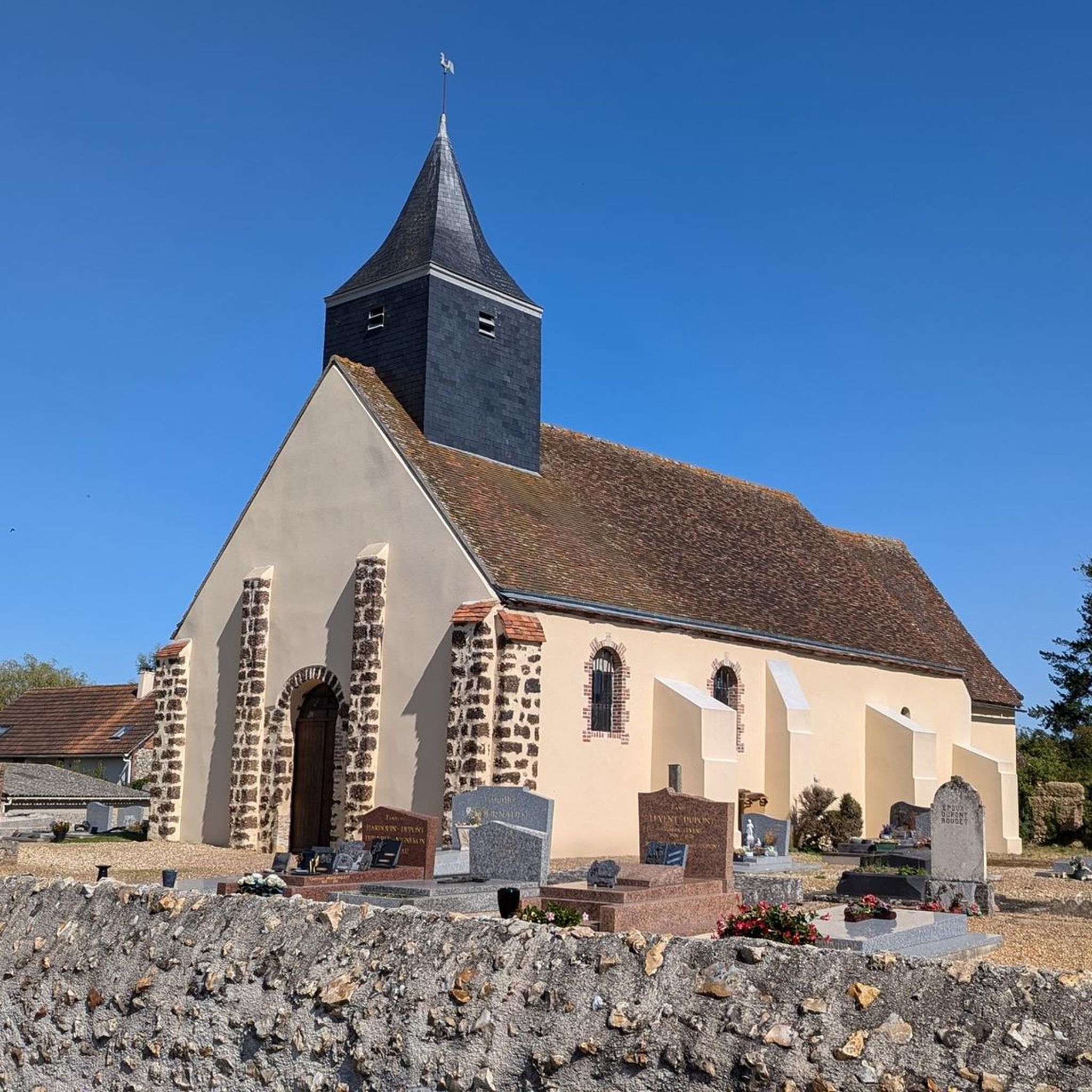
The Saint-Eloi Saint-Jean-Baptiste church in Crécy-Couvé is currently being restored. The spire of its bell tower, which was leaning dangerously, has been dismantled and is currently stored in the church awaiting restoration.
0
0

The Church of Saint-Éloi-Saint-Jean-Baptiste is believed to have originally been the chapel of the Château de Couvé, the first known mention of which dates back to 1215. This château belonged to the Abbey of Saint Père de Chartres. The layout of this chapel is currently unknown. Observing the architectural features of the current church allows us to place its construction between the 15th and 16th centuries. Improvement and modernization work were undertaken in the second half of the 18th century when Louis XV offered the Crécy estate to the Marquise de Pompadour: enlargement of the medieval windows, construction of an altarpiece forming a sacristy, a choir enclosure, and a gallery that could replace an older structure providing access to the attic. During this work, it is assumed that some of the bell tower's supports were removed to free up the nave and harmonize the interior spaces. After a prosperous period, the 19th and 20th centuries saw a slow deterioration of the building, despite some maintenance work being carried out on the roofs and other parts of the church that required it. It was only in 1901 that major work was undertaken, with the repair of the bell tower roof. This was followed in 1925 by work to consolidate the bell tower structures and repair the roofs of the western part of the nave. The bell tower and spire are tilting significantly to the south, linked to a failure of the old supports and the deterioration of the supporting structures, requiring urgent safety and restoration work.
0
0

The Rond du Roi are two pyramids which mark the limits of the former royal hunting domain. The pyramids date from the 18th century and are made of sandstone blocks. They are located at the intersection of forest roads, called Rond de France and Rond du Roi. This area offers plenty of woodland running trails with stunning views of the surrounding countryside.
2
0
The Rond des Quatres Barrières is a historic monument dating from the 18th century. It was built by the Duke of Penthièvre, owner of the neighboring castle of Châteauneuf-en-Thymerais. The Rond des Quatres Barrières is made up of four stone arches which form a circle, with a fountain in the center. It is located in the middle of the forest. The Rond des Quatres Barrières is the ideal place to visit during a running race.
2
0
Châteauneuf-en-Thymerais is a town with a rich history and magnificent forests. You can explore the remains of the old castle, the neoclassical town hall and the unique Notre-Dame du Pasme church, which was built with materials from the demolished castle. The Châteauneuf-en-Thymerais national forest, which extends over 1,743 hectares, also offers opportunities for discovering nature and wildlife. Châteauneuf-en-Thymerais is a favorite destination for runners of all levels.
2
0
The Rond du Roi are two pyramids that mark the boundaries of the former royal hunting grounds. The pyramids date from the 18th century and are made of blocks of sandstone. They are located at the intersection of forest roads, called the Rond de France and the Rond du Roi. This area offers pleasant walks in the woods, with some views of the surrounding countryside.
3
0
The Rond des Quatres Barrières is a historical monument dating from the 18th century. It was built by the Duke of Penthièvre, who owned the neighboring castle of Châteauneuf-En-Thymerais. The Rond des Quatres Barrières is made up of four stone arches that form a circle, with a fountain in the center. It is located in the middle of the forest. The Rond des Quatres Barrières is a peaceful and charming place to visit, especially in the spring or fall when the trees are in bloom or changing color.
2
0
Châteauneuf-en-Thymerais is a town with a rich history and magnificent forest. You can explore the remains of the old castle, the neoclassical town hall and the unique Notre-Dame du Pasme church, which was built with materials from the demolished castle. You can also enjoy nature and wildlife in the Châteauneuf-en-Thymerais national forest, which covers 1,743 hectares. Châteauneuf-en-Thymerais is a destination of choice for hikers who love history and nature.
2
0
Frequently Asked Questions
What kind of terrain can I expect on touring cycling routes around Saint-Sauveur-Marville?
The region offers a diverse cycling experience, transitioning from the vast plains of Beauce to the rolling hills of Perche. You'll find numerous rural paths winding through extensive woodlands and open fields, often featuring quiet roads and some gravel sections. Routes along the Eure and Loir rivers typically have low elevation changes, while other areas provide more challenging routes with elevation gains.
Are there many touring cycling routes available in the Saint-Sauveur-Marville area?
Yes, there are over 50 touring cycling routes around Saint-Sauveur-Marville. These routes cater to various skill levels, from easy loops to more challenging rides with significant elevation changes.
What are some notable landmarks or attractions I can see while cycling in the area?
The region is rich in historical sites and natural beauty. You can explore the forest of Châteauneuf-en-Thymerais, which features historical monuments like the 18th-century pyramids marking royal hunting grounds and the Rond des Quatres Barrières. Other attractions include Vérigny Castle, Château de Maillebois, and the Rond du Roi. The Véloscénie route, which passes through the department, also features the Château de Maintenon and Chartres Cathedral.
Are there any easy touring cycling routes suitable for beginners or a relaxed ride?
Absolutely. Many routes are suitable for a gentle ride. For example, the Mare Marchais loop from Saint-Sauveur-Marville is an easy 12.4 km (7.7 miles) route that takes about 43 minutes to complete, offering a pleasant journey through the local countryside. Another easy option is the Châteauneuf-en-Thymerais – Châteauneuf-en-Thymerais loop from Saint-Sauveur-Marville, which is 26.5 km (16.4 miles) long.
What about more challenging touring cycling routes for experienced cyclists?
For those seeking a greater challenge, routes like the Saulnières Town Hall loop from Le Gland offer a more demanding experience. This route covers 51.8 km (32.2 miles) with over 430 meters of elevation gain, making it one of the more difficult options in the area.
Are there any circular touring cycling routes around Saint-Sauveur-Marville?
Yes, many of the touring cycling routes in the area are loops, allowing you to start and end in the same location. Examples include the Rond du Roi loop from Châteauneuf-en-Thymerais, which explores woodlands and fields, and the Saint-Aignan Church – Saulnières Town Hall loop from Châteauneuf-en-Thymerais.
What do other touring cyclists say about the routes in Saint-Sauveur-Marville?
The touring cycling routes around Saint-Sauveur-Marville are highly rated by the komoot community, with an average score of 4.7 stars from over 30 reviews. Cyclists often praise the tranquil rural setting, the varied landscapes, and the quiet roads that make for a serene cycling experience.
Is Saint-Sauveur-Marville well-connected by public transport for cyclists?
While Saint-Sauveur-Marville itself is a rural commune, the Eure-et-Loir department is accessible. For detailed information on public transport options that accommodate bicycles, especially for reaching starting points of longer regional routes like the Véloscénie, it's best to consult local transport authorities or the official tourism website for Eure-et-Loir: tourisme28.com.
What is the best time of year to go touring cycling in Saint-Sauveur-Marville?
The region is enjoyable for cycling throughout much of the year. Spring and autumn offer pleasant temperatures and beautiful scenery with changing foliage or blooming fields. Summer is also suitable, especially for rides along river banks or through shaded forests. Always check local weather conditions before heading out.
Are there cafes or restaurants near the cycling routes in Saint-Sauveur-Marville?
Saint-Sauveur-Marville and nearby towns like Châteauneuf-en-Thymerais offer local amenities including cafes and restaurants where you can refuel. Given the rural nature of some routes, it's advisable to plan your stops or carry provisions, especially on longer rides through less populated areas.
Are the touring cycling routes in Saint-Sauveur-Marville suitable for families?
Yes, the region offers several easy routes with low elevation changes, particularly those along river banks or through flat agricultural plains, which are well-suited for family cycling. The quiet rural paths away from heavy traffic also contribute to a safe and enjoyable experience for families. Always check the specific route details for distance and difficulty to ensure it matches your family's abilities.
Are there any specific regulations or permits required for cycling on trails in Saint-Sauveur-Marville?
Generally, no specific permits are required for touring cycling on public roads and designated cycling paths in the Saint-Sauveur-Marville area. However, when cycling through private land or certain forest areas, it's always good practice to respect local signage and regulations. Always adhere to the French Highway Code.
Can I find parking easily for my car when starting a touring cycling route?
Parking is generally available in Saint-Sauveur-Marville and surrounding villages, especially near town centers or designated starting points for popular routes. For routes that begin in more rural areas or within forests like Châteauneuf-en-Thymerais, look for small parking areas or clearings often used by hikers and cyclists.
Most popular routes around Saint-Sauveur-Marville
Most popular attractions around Saint-Sauveur-Marville

Get inspired with the komoot mobile app


Explore more
Browse the best Cycling routes in other regions.
