The best walks and hikes around Dargan
4.6
(90)
1,253
hikers
30
hikes
Hiking around Dargan offers access to a landscape shaped by river valleys, historical sites, and forested hills. The region, situated near Harpers Ferry, West Virginia, features trails along the Potomac River and sections of the Appalachian Trail. Terrain includes moderate ascents to overlooks, flat canal paths, and more challenging routes through varied woodlands. This area provides a diverse range of outdoor experiences for hikers.
Best hiking trails around Dargan
- The most popular hiking route is Maryland Heights loop to stone fort and overlook – Harpers Ferry, West Virginia, a 6.6 miles (10.7 km) trail that takes 3 hours 30 minutes to complete. This route features historical fortifications and panoramic views of the surrounding area.
- Another top favourite among local hikers is Harpers Ferry to Weverton Cliffs via C&O Canal Trail, a moderate 8.9 miles (14.4 km) path. This trail follows the historic C&O Canal and includes a climb to scenic cliffs.
- Local hikers also love the Gathland State Park out & back – Appalachian Trail, a 20.2 miles (32.5 km) trail leading through sections of the Appalachian Trail, often completed in about 9 hours 10 minutes.
- Hiking around Dargan is defined by riverfront paths, historical landmarks, and forested hills. The network offers options for various ability levels, from easy strolls to challenging long-distance routes.
- The routes in Dargan are highly rated by the komoot community with an average score of 4.6 stars from over 80 reviews. More than 1,400 hikers have used komoot to explore Dargan's varied terrain.
Last updated: September 28, 2026
4.8
(25)
387
hikers
6.63km
02:04
210m
270m
Embark on the Maryland Heights via Harper's Ferry trail, a moderate hike that spans 4.1 miles (6.6 km) and climbs 704 feet (215 metres). You can expect to complete this route in about 2 hours and 3 minutes. As you ascend, you will pass through pleasant forested sections and encounter interesting rock formations, all leading to the iconic Maryland Heights Overlook. From there, you are treated to expansive views of historic Harpers Ferry, where the Potomac and Shenandoah Rivers meet, framed by the Blue Ridge Mountains.
To begin your hike, you will typically cross a footbridge from the charming town of Harpers Ferry, where parking is available. Keep in mind that this popular trail can become quite busy, especially on pleasant weekends, so planning your visit for off-peak times might offer a more serene experience. Consider starting early in the morning to avoid the largest crowds and secure parking more easily.
This route is a highlight within Harpers Ferry National Historical Park, renowned for its natural beauty and historical significance. The area's scenic vistas were even praised by Thomas Jefferson, underscoring its long-standing appeal. The trail offers a unique blend of natural exploration and a glimpse into a historically rich landscape, making it a notable destination for hikers in the region.
4.8
(4)
37
hikers
8.61km
02:19
90m
130m
Hike the Harpers Ferry Lower Town Trail Loop, a moderate 5.3-mile route through history and nature in Harpers Ferry National Historical Park

5.0
(2)
22
hikers
18.8km
05:16
430m
240m
The Appalachian Trail from Harpers Ferry to Gathland State Park is a diverse and challenging hike that blends historic townscapes with rugged mountain terrain. You'll begin by exploring the charming Harpers Ferry town before crossing the Potomac River and following the flat C&O Canal Towpath. The route then ascends into forested woodlands, leading to the spectacular Weverton Cliffs, which offer sweeping views of the river and surrounding landscape, making the 1404 feet (428 metres) of elevation gain well worth the effort.
This difficult 11.7-mile (18.8 km) hike, estimated to take 5 hours and 15 minutes, requires good physical fitness. Both Harpers Ferry and Gathland State Park provide convenient access and parking, but starting early is recommended to ensure you have enough time to complete the route and enjoy the viewpoints. Be prepared for varied terrain, including rocky sections and a significant climb, so sturdy footwear and plenty of water are essential for this demanding day out.
This section of the Appalachian Trail is steeped in history, traversing areas significant to the Civil War and passing through Harpers Ferry National Historical Park. It offers a unique opportunity to experience a blend of natural beauty and historical context, including the War Correspondents Arch at Gathland State Park. The contrast between the peaceful river path and the challenging mountain ridge makes this a memorable and rewarding journey for those who appreciate both nature and history.
5.0
(1)
4
hikers
5.74km
01:48
240m
200m
Embark on the Loudoun Heights Trail to Split Rock, an easy 3.6 miles (5.7 km) hike that takes you through secluded Virginian hardwood forests. You will gain 783 feet (239 metres) of elevation over approximately 1 hour and 48 minutes. As you hike, you can enjoy views of the Potomac River before reaching the Split Rock Overlook, which offers panoramic vistas of Harpers Ferry, Maryland Heights, and the impressive confluence of the Shenandoah and Potomac Rivers. This route provides a rewarding outdoor experience for hikers looking for scenic beauty. You will find the trail to be a pleasant journey through nature. The path is well-defined and offers a good workout without being overly strenuous.
When planning your visit, be aware that parts of the trail can be rocky, especially after rain, so sturdy hiking shoes are highly recommended for your comfort and safety. Parking is typically available near the trailhead, making access straightforward. Before you head out, it is always a good idea to check for any current conditions or specific advisories from Harpers Ferry National Historical Park. This will help ensure you have the most up-to-date information for your trip. Consider starting your hike earlier in the day to enjoy cooler temperatures and fewer crowds. Always carry enough water, especially on warmer days.
This trail is situated within the historic Harpers Ferry National Historical Park, adding a layer of rich context to your outdoor adventure. The Split Rock Overlook is particularly notable for being one of the most scenic viewpoints in the area, offering a unique perspective on the landscape. The confluence of two major rivers, the Shenandoah and the Potomac, creates a dramatic natural spectacle that is a highlight of the region. This hike is a great way to explore the natural beauty and historical significance of this unique area. You will appreciate the blend of natural scenery and historical importance. It is a perfect choice for a leisurely yet engaging outdoor activity.
3.0
(1)
4
hikers
9.48km
02:40
200m
140m
This section of the Appalachian Trail, the Harpers Ferry to Weverton Trail, offers a diverse experience, starting with a flat, peaceful stroll along the C&O Canal Towpath beside the Potomac River. You'll pass historic sites and enjoy views of the river's confluence before the trail takes a significant turn upwards. The highlight for many is the panoramic vista from Weverton Cliffs, providing sweeping 180-degree views of the Potomac and surrounding mountains after a rewarding climb.
Plan for a moderate 5.9-mile (9.5 km) hike with 660 feet (201 metres) of elevation gain, typically taking around 2 hours and 40 minutes. The initial flat section is easy, but the ascent to Weverton Cliffs is steep and rocky, requiring a good effort. Parking is available at Harpers Ferry National Historical Park (which may have a fee) or at Weverton Road, allowing for a shorter out-and-back to the cliffs if you prefer.
This trail is a well-known segment of the Appalachian Trail, with Harpers Ferry often considered the symbolic halfway point for thru-hikers. It blends natural beauty with rich Civil War history, passing through Harpers Ferry National Historical Park. Dogs are welcome but must be leashed, and the trail is a great introduction to mountain hiking for novices, offering a taste of varied terrain and rewarding views.
Get access to more routes and recommendations from other explorers.
Already have an account?
Our route recommendations are based on thousands of hikes, rides, and runs completed by other people on komoot.
Start today with a free account
Your next adventure awaits.



Tips from the Community

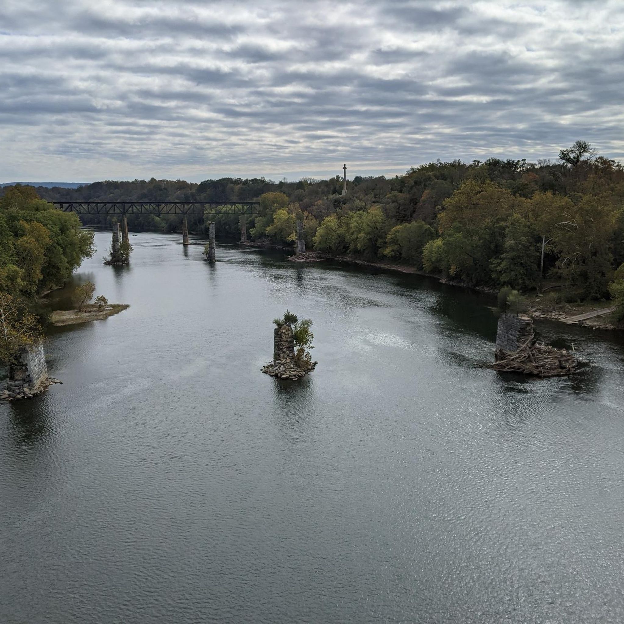
The pedestrian path offers a beautiful view of the striking bridge piers from past days.
1
0
Highly recommended viewpoint with the most beautiful view of Harpers Ferry, the rivers, and striking bridge structures.
1
0

One of my favorite rides! The trail is well maintained and smooth. So many spots to rest and take breathtaking pics
1
0

28 Sept 2025: staircase closed as they rebuild it
0
0

to get from trail to Harper's Ferry, you have to go up these stairs. There are bike racks at the base, or you carry your bike up with you
0
0

The Potomac River has a mix of flatwater and whitewater, visible as you pedal along the C&O Canal bike trail; this is a great spot to stop and watch some of those rapids.
0
0

Survived the Civil War battles nearby untouched. It’s a “Miracle”.
0
0
Great place to rest for a water break or snack. Lots of logs to sit right on trail.
0
0
Frequently Asked Questions
How many hiking trails are available around Dargan?
There are over 25 hiking routes around Dargan listed on komoot, offering a diverse range of experiences. These include 13 easy, 10 moderate, and 5 difficult trails, catering to various skill levels and preferences.
What makes hiking around Dargan unique?
Hiking around Dargan is unique due to its blend of natural beauty and historical significance. The region features trails along the Potomac River, sections of the iconic Appalachian Trail, and historical sites like fortifications and canal paths. You'll find a mix of river valleys, forested hills, and moderate ascents to scenic overlooks.
Are there easy hiking trails suitable for beginners in Dargan?
Yes, Dargan offers several easy hiking trails perfect for beginners or those looking for a relaxed stroll. An excellent option is the Bolivar Heights and Schoolhouse Ridge North loop – Harpers Ferry, West Virginia, which is just over 3 miles long with minimal elevation gain. Another easy choice is the Camp Hill and Virginius Island loop – Harpers Ferry, West Virginia, offering a shorter, flat path.
What are some challenging hiking options in the Dargan area?
For experienced hikers seeking a challenge, the Dargan area provides more demanding routes. The Gathland State Park out & back – Appalachian Trail is a difficult 20.2-mile trail that takes approximately 9 hours 10 minutes to complete, offering a significant test of endurance through varied terrain.
Are there any family-friendly hiking trails around Dargan?
Many trails around Dargan are suitable for families, especially those along the C&O Canal, which offer flat and wide paths. The Camp Hill and Virginius Island loop – Harpers Ferry, West Virginia is a great short and easy option for families with younger children.
What historical landmarks or attractions can I see along the hiking trails?
The Dargan area is rich in history. Along the trails, you can explore significant sites such as the Maryland Heights Stone Fort, which offers panoramic views and historical context. Other notable attractions include Jefferson Rock, known for its scenic overlook, and the Goodloe E. Byron Memorial Pedestrian Walkway, which is a historic railroad bridge.
Are dogs allowed on hiking trails in Dargan?
Many trails in the Dargan area, particularly those within the Harpers Ferry National Historical Park and along the C&O Canal, are dog-friendly, provided dogs are kept on a leash. Always check specific trail regulations before heading out, but generally, your canine companion can join you on most adventures here.
What do other hikers enjoy most about hiking in Dargan?
The trails around Dargan are highly rated by the komoot community, with an average score of 4.6 stars from over 80 reviews. Hikers frequently praise the region's diverse scenery, which includes riverfront paths, historical landmarks, and beautiful forested hills, as well as the well-maintained routes that cater to various ability levels.
Are there any circular hiking routes in the Dargan region?
Yes, there are several circular routes available. A popular choice is the Maryland Heights loop to stone fort and overlook – Harpers Ferry, West Virginia, which is a moderate 6.6-mile loop offering historical fortifications and stunning views. The Bolivar Heights and Schoolhouse Ridge North loop – Harpers Ferry, West Virginia is another excellent, easier circular option.
Is there parking available near the trailheads in Dargan?
Parking is generally available at or near many trailheads, especially around popular areas like Harpers Ferry National Historical Park and access points to the C&O Canal Towpath. It's advisable to arrive early during peak seasons or weekends, as parking lots can fill up quickly. Some areas may have designated parking fees.
What is the best time of year to go hiking in Dargan?
Spring and autumn are generally considered the best times for hiking in Dargan. Spring brings blooming wildflowers and comfortable temperatures, while autumn offers spectacular fall foliage. Summer can be hot and humid, but early mornings or late afternoons are still pleasant. Winter hiking is possible, but some trails may be icy or muddy, requiring appropriate gear.
Are there any trails that follow the C&O Canal near Dargan?
Absolutely. The historic C&O Canal Towpath runs through the Dargan area, providing flat and scenic hiking opportunities. A notable route is Harpers Ferry to Weverton Cliffs via C&O Canal Trail, which follows the canal before ascending to the scenic Weverton Cliffs.
Most popular attractions around Dargan

Get inspired with the komoot mobile app


Explore more
Browse the best Hikes in other regions.
