Routes

Planner

Features

Updates

App

Login or Signup

Get the App

Login or Signup

Routes
Hikes
Canada
British Columbia

Alouette Lake

The best walks and hikes around Alouette Lake

4.5

(52)

962

hikers

21

hikes

Hiking around Alouette Lake offers diverse landscapes within Golden Ears Provincial Park, characterized by a large glacial-fed lake surrounded by conifer-covered mountains. The region features varied terrain, including sandy estuaries, dense forests, and rugged backcountry. Hikers can explore trails along the Alouette River and discover several waterfalls, providing a range of natural features for outdoor activity.

Best hiking trails around Alouette Lake

  • The most popular hiking route is West Canyon Trail Parking Lot loop from Alouette Campground, a 6.6 miles (10.7 km) trail that takes 3 hours 2 minutes to complete, offering a moderate journey through forested areas.
  • Another top favourite among local hikers is Mount Robie Reid Trail — Golden Ears Provincial Park, a difficult 11.9 miles (19.1 km) path leading to a striking summit with significant elevation gain.
  • Local hikers also love the West Canyon Trail Parking Lot loop from West Canyon parking lot, a 5.0 miles (8.1 km) trail leading through varied terrain, often completed in about 2 hours 15 minutes.
  • Hiking around Alouette Lake is defined by its glacial lake, dense conifer forests, and rugged mountains. The network offers options for different ability levels, from gentle walks to challenging alpine ascents.
  • The routes in Alouette Lake are highly rated by the komoot community with an average score of 4.7 stars from over 40 reviews. More than 800 hikers have used komoot to explore Alouette Lake's varied terrain.

Last updated: August 15, 2026

5.0

(2)

5

hikers

#1.

West Canyon Trail Parking Lot loop from P2

23.2km

06:34

450m

450m

Hard hike. Very good fitness required. Sure-footedness, sturdy shoes and alpine experience required.

Navigate with device

Send to Phone

Save

Hard

Hard hike. Very good fitness required. Sure-footedness, sturdy shoes and alpine experience required.

Hard
guide_signup
Let us show you the way with the komoot mobile app
With a free komoot account, you can easily find, customize, and navigate endless outdoor adventures.

Sign up for free

Easy hike. Great for any fitness level. Easily-accessible paths. Suitable for all skill levels.

Easy

Moderate hike. Good fitness required. Easily-accessible paths. Suitable for all skill levels.

Moderate

4.8

(12)

115

hikers

Hard hike. Good fitness required. Sure-footedness, sturdy shoes and alpine experience required.

Hard
Sign up for free to see 17 more hikes around Alouette Lake.

Get access to more routes and recommendations from other explorers.

Sign up for free

Already have an account?

Our route recommendations are based on thousands of hikes, rides, and runs completed by other people on komoot.

Start today with a free account

Your next adventure awaits.

Login or Signup

Popular around Alouette Lake

Running Trails around Alouette Lake

Road Cycling Routes around Alouette Lake

Tips from the Community

Oceanpaddle
July 2, 2026, Lower Falls, Golden Ears Provincial Park

Park gate closes at 11pm. On summer weekends you'll need a half or full day pass for parking

0

0

Scott
March 22, 2026, Spirea Nature Trail

The trail here is almost entirely a flat, with a wooden boardwalk designed to protect the sensitive peat bog beneath. The most unique feature here is the sphagnum moss bog. This rare ecosystem acts like a giant sponge, filtering rainwater and supporting plants that you won't see on the higher mountain ridges.

0

0

While most park trails are steep and rugged, this one is remarkably flat and wide because it follows an old 1920s railway grade once used for logging.

0

0

One of the most striking summits in Golden Ears Provincial Park, Mount Robie Reid rises to 2,095 metres above the Alouette Valley, offering panoramic views of the Fraser Valley, Pitt Lake, and the Coast Mountains. The route to the top is steep and technical, suited for experienced hikers and scramblers seeking a true backcountry challenge.

0

0

A steep, rugged climb that starts by skirting along the shore of Alouette Lake before turning upward through dense forest toward the alpine bowl – expect heavy elevation gain and rewarding views toward the Fraser Valley.

0

0

oliviakellis
October 20, 2025, Alouette River

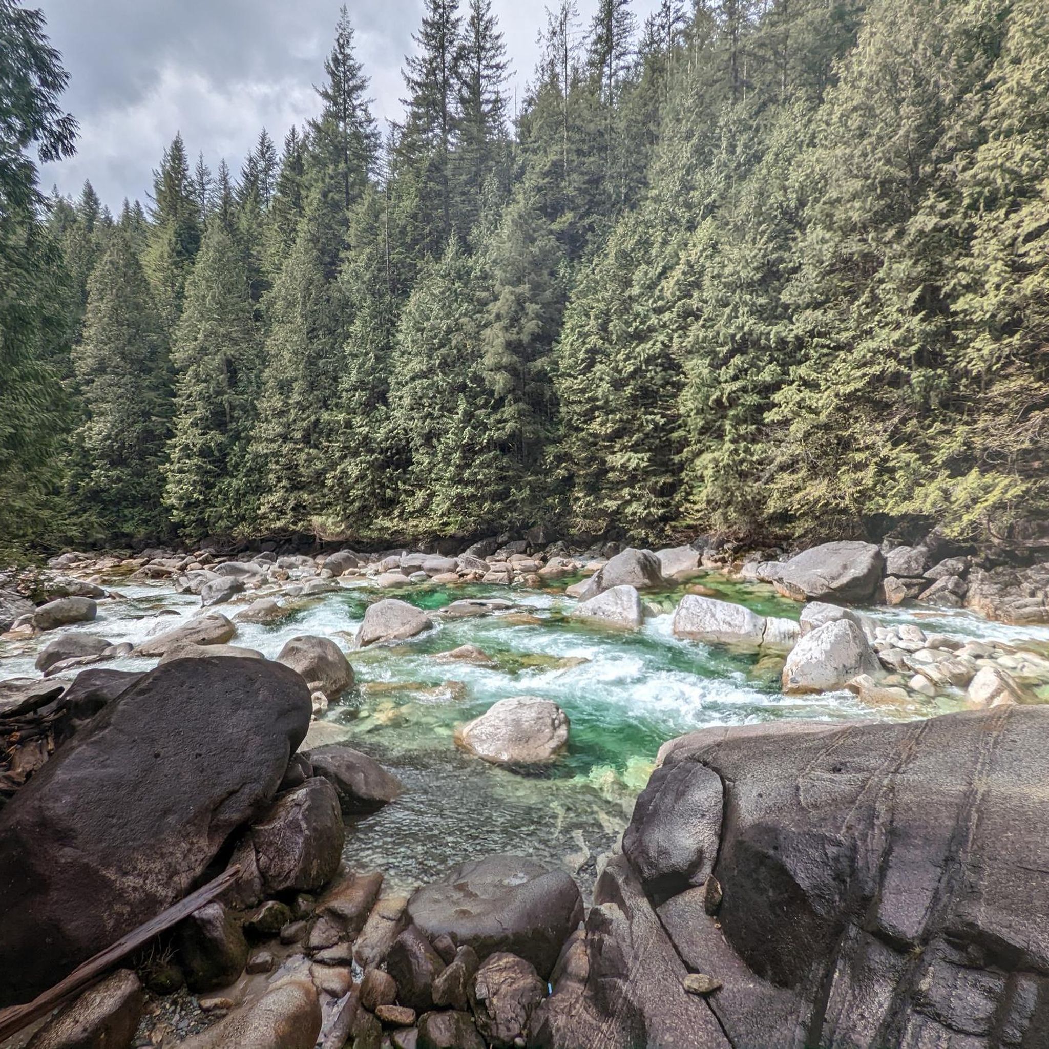
A serene stop along the Mount Robbie Reid Trail, where the Alouette River flows through smooth boulders and dense forest. Fed by snowmelt from the nearby peaks, it’s a refreshing spot to pause and take in the sound of rushing water before the climb begins.

0

0

most beautiful early in the morning

0

0

Pretty cool portion of the trail where it hugs the cliff side. Not too exposed, but may be difficult for people who are afraid of heights or small children.

0

0

Frequently Asked Questions

How many hiking trails are available around Alouette Lake?

There are over 15 hiking routes around Alouette Lake, offering a wide range of experiences from easy strolls to challenging alpine ascents. The komoot community has explored more than 150 km of trails in the area.

Are there any family-friendly hiking trails near Alouette Lake?

Yes, Alouette Lake offers several family-friendly options. The Lower Falls Trail is a popular choice, leading through the forest to Gold Creek Falls with minimal elevation gain. Another easy option is the West Canyon Trail Parking Lot loop from Alouette Campground, which is a moderate 10.7 km route through forested areas.

Which trails are suitable for hikers with dogs?

Many trails in Golden Ears Provincial Park are dog-friendly. The Lower Falls Trail is a great option for a walk with your canine companion. Always ensure dogs are kept on a leash and follow park regulations regarding pet waste.

Can I find trails with waterfalls around Alouette Lake?

Absolutely. The region is home to several beautiful waterfalls. You can visit the easily accessible Lower Falls, the more secluded Upper Falls, Gold Creek Falls, and Rolley Falls. The Lakeside Trail & Rolley Falls Trail loop specifically offers views of both the lake and waterfalls.

Are there any accessible trails for wheelchairs or strollers?

Yes, the Spirea Nature Trail is a short, magical forest loop that is wheelchair-accessible, providing a relaxing experience for all visitors.

What are the most challenging hikes in the Alouette Lake area?

For experienced hikers seeking a challenge, the Alouette Lake area offers rugged alpine routes. The Mount Robie Reid Trail — Golden Ears Provincial Park is a difficult 19.1 km path with significant elevation gain, leading to a striking summit. Other demanding options include the Golden Ears Summit Trail and the Alouette Mountain hike.

Are there any loop trails available for hiking?

Yes, several loop trails are available. The West Canyon Trail Parking Lot loop from West Canyon parking lot is a popular 8.1 km moderate route. Other loops include the Burke Mountain loop and the Kanaka Creek Regional Park loop, offering varied terrain and scenic views.

What kind of natural features can I expect to see while hiking?

Hiking around Alouette Lake offers diverse scenery. You'll encounter sandy estuaries, dense conifer forests, and rugged backcountry. The trails often meander along the Alouette River, and you'll have views of the expansive, glacial-fed Alouette Lake itself, surrounded by mountains like Evans Peak, Mount Nutt, and Mount Gatey.

Is there parking available at the trailheads?

Yes, parking is generally available at various trailheads within Golden Ears Provincial Park. For example, there are parking lots at the West Canyon Trail Parking Lot and Gold Creek Parking, which serve as starting points for many routes.

What is the best time of year to go hiking around Alouette Lake?

The best time for hiking around Alouette Lake is typically from late spring through early autumn (May to October) when the weather is milder and trails are clear of snow. However, some lower elevation trails can be enjoyed year-round, with proper gear for winter conditions.

What do other hikers say about the trails in Alouette Lake?

The trails around Alouette Lake are highly regarded by the komoot community, with an average rating of 4.7 stars from over 40 reviews. Hikers often praise the diverse landscapes, from the serene lake views to the challenging mountain ascents, and the well-maintained paths.

Can I go swimming in Alouette Lake after a hike?

Yes, Alouette Lake is a popular spot for swimming, especially at the South Beach area. Its crystal-clear, glacial-fed waters offer a refreshing dip after a hike, with stunning views of the surrounding mountains.

Most popular routes around Alouette Lake

Easy hikes around Alouette Lake

Store rating

Get inspired with the komoot mobile app

With a free komoot account, you can easily find, customize, and navigate endless outdoor adventures.

or

Join komoot Now

Store rating

Explore more

Browse the best Hikes in other regions.

Rocky MountainsSelkirk MountainsMonashee MountainsElectoral Area AVancouverVancouver IslandAlberni-ClayoquotMetro Vancouver Regional ParksArea C (Pemberton Valley/Mount Currie/D'Arcy)Area A (Kicking Horse/Kinbasket Lake)Area D (Oyster Bay/Buttle Lake)Area D (Elaho/Garibaldi)BurnabySaanichNanaimoEast Central Okanagan Electoral AreaColony Farm Regional ParkCentral Okanagan JFraser River Delta -- RamsarOkanagan LakeArea B (South Fraser Canyon/Sunshine Valley)Area A (Baynes Sound)Area G (Forster Creek/Mount Assiniboine)Purcell MountainsArea E (Chilliwack River Valley)Sunshine Coast Regional DistrictSurreyArea F (McConnell Creek/Hatzic Prairie)Brackendale Eagles Provincial ParkArea P (Rivers and the Peaks)Stave West Forest & Recreation AreaAbbotsfordFraser Islands Regional Park ReserveLangleySurrey Bend Regional ParkArea B (Shelter Bay/Mica Creek)Coquitlam WatershedArea F (Grindrod/Ashton Creek/Mabel Lake)Robert'S Lake Regional ParkArea A (Upper Flathead/Elk Valley)Yoho National ParkArea L (Grasslands)Area F (Columbia Lake/Windermere Lake)Nanaimo GCowichan Valley GHazelton MountainsCariboo MountainsArea G (Deroche/Dewdney/Sumas Mountain)Area H (Lighthouse Country)Kanaka Creek Regional ParkArea A (Kyuquot/Nootka/Sayward)North Okanagan BGlen Valley Regional ParkArea C (Moyie/Bull River)Tynehead Regional ParkArea A (Wells Gray Country)Kootenay National ParkArea C (Arrowsmith-Benson)Maple RidgeOkanagan Mountain Provincial ParkBeaver Lodge Forest LandsRichmondStave LakeBeaufort East WoodlandsArea C (Puntledge/Black Creek)Pacific Rim National Park Reserve - Long Beach UnitNorth CowichanAkamina-Kishinena Provincial ParkStephens Coyote Ridge Regional ParkK'Ómoks Royston LandsBlaney Bog Regional Park ReserveUpper Trent River WoodlandsArea C (Sasquatch Country)Burns Bog Ecological Conservancy AreaArea D (Falkland/Silver Creek)Stikine RegionUpper Qualicum River WoodlandsShuswap LakeCentral SaanichGaribaldi Provincial ParkTelemark Cross-Country Ski Trails Recreation SiteBurnaby Lake Regional ParkWells Gray Provincial ParkWoodley Range Ecological ReserveVictoriaStrathcona Provincial ParkEagle Mountain Recreation SiteArea N (Beautiful Nicola Valley - South)Iona Beach Regional ParkBlackcomb Glacier Provincial ParkDeltaArea H (Robson Valley/Canoe)Elk Falls Provincial ParkUpper Little Qualicum River WoodlandsTsable Lakes WoodlandsCapital GDawley Passage Provincial ParkCrown Land ReserveBlue Mountain Recreation SiteTəmtəmíxʷtən/Belcarra Regional ParkArea H (The Slocan Valley)Pitt MeadowsArea F (Alberni Highway)Area C (Blind Bay/Sorrento)Columbia National Wildlife AreaUpper Puntledge River WoodlandsStawamus Chief Provincial ParkArea B (Paradise Valley)Comox Valley B (Lazo North)Cypress Provincial ParkPowell LakeWhistler Interpretive ForestArea A (Malaspina/Toba)SpallumcheenStanley Park National Historic SiteArea B (Lake Koocanusa)Area C (Chilako River/Nechako)Sayres Lake Recreation SiteShowh Lakes-Ancient Cedars Trail Recreation SiteLittle Qualicum Falls Provincial ParkArea H (Manning Park/Tulameen/Siwash)Callaghan ConservancyFraser Valley DPacific Rim National Park Reserve - West Coast Trail UnitTantalus Provincial ParkGowlland Tod Provincial ParkArea B (Discovery Islands/Mainland Inlets)Area E (Eagle River Valley)Mount Revelstoke National ParkSumas Mountain Regional ParkArea F (Scotch Creek/Seymour Arm)Sooke Hills Wilderness Regional ParkCapilano River Regional ParkKennedy Lake Provincial ParkJuan De Fuca Provincial ParkAlberni - Ash River WoodlandsDeas Island Regional ParkAyum Creek Regional Park ReserveBurnaby Mountain Conservation AreaArea E (Naramata/Greyback)Harrison LakeInland Lake Provincial ParkE.C. Manning Provincial ParkAlberni Beaufort Range WoodlandsUbc Malcolm Knapp Research ForestMount Seymour Provincial ParkWidgeon Marsh Regional Park ReserveVictoria Harbour Migratory Bird SanctuaryArea J (Copper Desert Country)Pacific Spirit Regional ParkMount Geoffrey Escarpment Provincial ParkArea D (Lardeau Valley/Duncan Lake)Minnekhada Regional ParkMount Arrowsmith Regional Park (Acrd)Codd Wetland Ecological Conservancy AreaBoyle Point Provincial ParkStrathcona Park - Upper Puntledge River WatershedLynn Headwaters Regional ParkSx̱Ótsaqel / Chilliwack Lake Provincial ParkPinecone Burke Provincial ParkArea E (Moberly Lake/Sukunka Valley)Epper Passage Provincial ParkArea I (Youbou / Meade Creek)Grouse Mountain Regional ParkArea A (North Skeena)Cultus Lake Provincial ParkBuntzen Lake Recreation AreaMacmillan Provincial ParkArea E (Balfour/Cottonwood Lake)Thwaytes Landing Regional ParkArea D (Trinity/West Creighton)Mount Arrowsmith Massif Regional Park (Rdn)Area E (Saint Mary/Skookumchuck)Alberni - Great Central Lake WoodlandsThacker Regional ParkStamp River Provincial ParkLower Seymour Conservation ReserveCrippen Regional ParkMount Terry Fox Provincial ParkArea C (Lois Lake/Saltery Bay)Rathtrevor Beach Provincial ParkFlorence Lake Recreation ReserveCougar Canyon Ecological ReserveArea A (Upper Bridge River Valley)Coquihalla Summit Recreation AreaArea B (Lower Columbia/Old Glory)Seymour WatershedGoldstream Provincial ParkMount Gardner Recreation SiteGolden Ears Provincial ParkCowichan Valley FNorth SaanichLarch Hills Trails Recreation SiteHelliwell Provincial ParkArea F (Willow River/Upper Fraser)Brandywine Falls Provincial ParkValhalla Provincial ParkArea K (The Arrow Lakes)Ƚáu,Welṉew̱/John Dean Provincial ParkArea E (Cherryville/East Creighton)Liumchen Ecological ReserveMt Begbie Area Recreation SiteBoundary Bay Regional ParkArea B (Cayoosh/Pavilion)Area H (Canim Lake/Forest Grove)North Cowichan Municipal Forest ReserveMount Assiniboine Provincial ParkPitt LakeCarmanah Walbran Provincial ParkSkeena MountainsNanaimo EMount Begbie Recreation SiteArea O (Lower North Thompson)Area D (Nimpkish Valley/Cormorant Island)Mount Fernie Provincial ParkEsté-Tiwilh/Sigurd Creek ConservancyCapilano WatershedWest Arm Provincial ParkOkanagan-Similkameen DBowen Island Ecological ReserveNorthern RockiesKootenay Boundary ENairn Falls Provincial ParkSooke Mountain Provincial ParkMount Robson Provincial ParkSalt Spring Island Electoral AreaArea F (Trout Creek Valley)Area D (Tabor Lake/Stone Creek)Myra-Bellevue Provincial ParkStebbings Road Community ForestSasquatch Provincial ParkHillkeep Regional ParkMain Lake Provincial ParkArea B (Shawnigan Lake)Area A (Hudson Bay Mountain)Mt. Macpherson Cross-Country Trails Recreation SiteVedder Mountain Interpretative ForestElk Lakes Provincial ParkButtle LakeCheam Wetlands Regional Park

Nearby adventure guides

Things to Do in Blue Mountain Recreation Site

background

Get ready to conquer new peaks

Sign up for Free

Explore
RoutesRoute plannerFeaturesRedeem a voucherHikesMTB TrailsRoad cycling routesBikepackingSitemap
Download the app
Follow Us on Socials

© komoot GmbH

Privacy Policy