The best running trails around Area A (Wells Gray Country)
4.3
(4)
90
runners
5
runs
Jogging routes around Area A (Wells Gray Country) traverse a diverse landscape shaped by volcanic activity and glaciers. The region is characterized by numerous waterfalls, pristine lakes, and river valleys, offering varied terrain for running. Expansive old-growth rainforests and alpine meadows contribute to the natural beauty, with the Cariboo and Shuswap mountain ranges providing a rugged backdrop. This area features a network of trails suitable for various fitness levels, from easy riverside paths to more challenging ascents.
Best jogging routes…
Last updated: July 18, 2026
44
runners
5.13km
00:33
100m
100m
Moderate run. Good fitness required. Mostly paved surfaces. Suitable for all skill levels.
3.7
(3)
16
runners
6.08km
00:48
90m
90m
Hard run. Good fitness required. Sure-footedness, sturdy shoes and alpine experience required.

Sign up for free
5.0
(1)
21
runners
7.94km
00:59
70m
70m
Moderate run. Good fitness required. Mostly paved surfaces. Suitable for all skill levels.
6
runners
14.9km
02:16
360m
360m
Hard run. Very good fitness required. Sure-footedness, sturdy shoes and alpine experience required.
3
runners
5.17km
00:35
80m
80m
Moderate run. Good fitness required. Mostly paved surfaces. Suitable for all skill levels.
Our route recommendations are based on thousands of hikes, rides, and runs completed by other people on komoot.
Start today with a free account
Your next adventure awaits.
Login or Signup
Popular around Area A (Wells Gray Country)
Tips from the Community

Simply spectacular. The short hike of just under 3km is easily manageable. The descent to the foot of the waterfall is a bit more challenging because the stones are partly very slippery. But you will be rewarded.
0
0

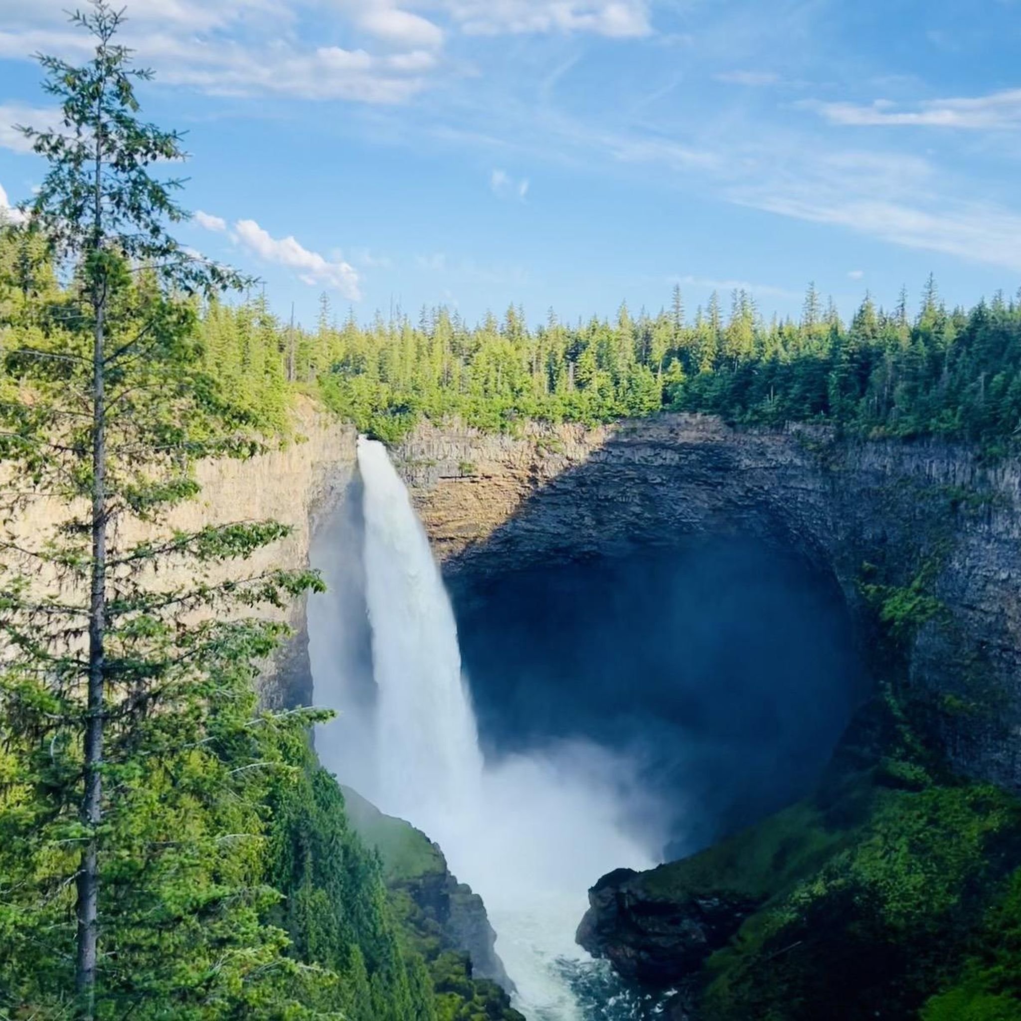
The Murtle River has to be one of the most scenic rivers in all of Canada. Getting its start at the foot of a glacier in the Cariboo Mountains the Murtle River is the largest tributary of the Clearwater River. Along its short 36-kilometre run the Murtle River has seven named waterfalls, including the iconic Helmcken Falls in Wells Gray Provincial Park. Thankfully there are trails tracing along the course of the river by much of its route so you can get out and enjoy this short, but stunning, river.
0
0
At over 140 metres tall, it's easy to see why Helmcken Falls was one of the main reasons for the formation of Wells Gray Provincial Park. While the spectacular waterfall is a main draw during the busy summer season, the area is also popular with ice climbers during winter and the falls are known as the "Yosemite of ice climbing".
1
0

A tough climb, but really cool.
3
0
So incredibly cool! You don't want to miss this.
3
0

The hike to Helmcken Falls starts from its own parking lot, located directly on the 30-mile bend.
0
0

It is possible to walk behind the waterfall to the opposite side of the creek without having to wade through the water. However, you will be splashed by the spray from the Falls. (Visit June 3, 2018)
3
0
Grouse Creek forms a beautiful waterfall in Wells Gray Park. Moul Falls plunges 35 metres over an eroded rock ledge into the narrow valley. It is possible to walk behind the waterfall to the opposite side of the creek without having to wade through the water. However, you will be splashed by the spray from the Falls. (Visit June 3, 2018) https://www.worldwaterfalldatabase.com/waterfall/Moul-Falls-2298
3
0
Frequently Asked Questions
How many jogging routes are available in Area A (Wells Gray Country)?
There are 5 dedicated jogging routes listed on komoot for Area A (Wells Gray Country). These routes offer a mix of moderate and difficult options, traversing the region's diverse landscapes.
Are there running routes suitable for families in Wells Gray Country?
Yes, Wells Gray Country offers trails suitable for various fitness levels. While all routes listed on komoot are rated moderate to difficult, the region generally has many trails that can be enjoyed by families, often leading to scenic viewpoints or waterfalls. Always check the specific route details for distance and elevation to ensure it matches your family's capabilities.
Can I bring my dog on the jogging trails in Wells Gray Country?
Wells Gray Provincial Park generally allows dogs on trails, but they must be kept on a leash at all times. It's always a good practice to check the specific regulations for each trail or park area you plan to visit, as rules can vary. Be mindful of wildlife and pack out all waste.
What kind of terrain can I expect on the running routes in Wells Gray Country?
The running routes in Wells Gray Country traverse a diverse landscape shaped by volcanic activity and glaciers. You can expect varied terrain including paths through dense forests, alongside rivers, and near dramatic waterfalls. Some routes may feature moderate elevation changes, offering a good workout amidst stunning natural beauty.
Are there any circular jogging routes in Wells Gray Country?
Yes, several routes in the area are circular, allowing you to start and end at the same point. For example, the Moul Falls loop from Moul Falls is a popular circular option, as is the Helmcken Falls loop from Rim Trail.
What natural features can I see along the jogging routes?
Wells Gray Country is renowned as 'Canada's Waterfall Park,' so you'll encounter numerous cascades. Notable waterfalls include Moul Falls, Helmcken Falls, Spahats Creek Falls, and Dawson Falls. The routes also offer views of volcanic formations, pristine lakes, and dense forests.
Are there any challenging running trails for experienced runners?
Yes, for those seeking a more demanding run, the Osprey Lookout loop from Clearwater River is rated as difficult. This route covers nearly 15 kilometers with significant elevation gain, providing a rigorous challenge and rewarding views.
What do other runners enjoy most about jogging in Area A (Wells Gray Country)?
The area is highly rated by the komoot community, with an average score of 4.3 stars from 4 reviews. Runners often praise the stunning natural beauty, particularly the dramatic waterfalls and diverse landscapes, which make for a memorable outdoor experience.
Are there any running routes near the town of Clearwater?
Yes, Clearwater serves as a gateway to many of the region's trails. You can find routes like the Running loop from Clearwater, which explores the area around the town and its access to lakes and rivers. Another option is the Running loop from Clearwater, offering another perspective of the local surroundings.
Is parking available at the trailheads for these jogging routes?
Parking is generally available at the main trailheads within Wells Gray Provincial Park, especially for popular attractions like Moul Falls and Helmcken Falls. It's advisable to arrive early during peak season to secure a spot, particularly for the more well-known routes.
What is the best time of year to go jogging in Wells Gray Country?
While Wells Gray Country is a year-round destination, late spring through early fall (May to October) generally offers the most ideal conditions for jogging. During this period, trails are typically clear of snow, and the weather is pleasant, allowing for full enjoyment of the waterfalls and lush landscapes. Summer also brings spectacular wildflower blooms in alpine meadows.
Most popular routes around Area A (Wells Gray Country)
Most popular attractions around Area A (Wells Gray Country)

Get inspired with the komoot mobile app


Explore more
Browse the best Running Trails & Routes in other regions.
