The best road cycling routes around Aughlish
4.7
(23)
1,125
riders
30
rides
Road cycling routes around Aughlish traverse a rural landscape characterized by undulating terrain and quiet country roads. The region, located in County Londonderry, Northern Ireland, offers varied gradients suitable for different fitness levels. Cyclists can experience views of the nearby Sperrin Mountains, an Area of Outstanding Natural Beauty, providing a scenic backdrop to rides. The area's topography includes rolling hills, making for diverse road cycling experiences.
Best road cycling routes around Aughlish
- The most popular road cycling route is Scarva…
Last updated: November 2, 2026
29
riders
93.0km
04:03
860m
860m
Moderate road ride. Good fitness required. Mostly well-paved surfaces and easy to ride.
21
riders
72.8km
03:05
550m
550m
Moderate road ride. Good fitness required. Mostly well-paved surfaces and easy to ride.

17
riders
95.6km
04:15
940m
940m
Hard road ride. Very good fitness required. Mostly well-paved surfaces and easy to ride.
11
riders
111km
04:57
1,140m
1,140m
Hard road ride. Very good fitness required. Mostly well-paved surfaces and easy to ride.
9
riders
69.3km
02:49
310m
310m
Moderate road ride. Good fitness required. Mostly well-paved surfaces and easy to ride.
Get access to more routes and recommendations from other explorers.
Already have an account?
Our route recommendations are based on thousands of hikes, rides, and runs completed by other people on komoot.

Tips from the Community

Small coffeeshop right by the river Bann, directly next to Sustrans Route 9 / Newry Canal Towpath. The cafe is practically on the roadside, making it a logical stop for cyclists following the canal path. The old brick building has a relaxed atmosphere; inside and out it's a place where cyclists and walkers cross paths. Ideal for a coffee, a small snack and a short break before you cycle back into the canal landscape towards Craigavon Lakes. Enjoyed the stop, but forgot the photo.
7
0
Along the picturesque route near the River Bann, you'll find the Moyallan Pillbox. Built around 1940 as part of Britain's coastal and inland defences, this compact bunker served as an observation post and machine gun nest. Strategically positioned to guard the river crossing and nearby roads, this robust structure is a reminder of a time when this peaceful landscape was on high alert. For the passing cyclist, it's an intriguing stop; its moss-green walls blend almost seamlessly with the surrounding nature, revealing the bunker's secrets only at the last moment. A raw piece of military heritage that sharply contrasts with the tranquility of the present-day countryside.
6
0
The entrance to Lisnamintry Rath (located on Ballygargan Road, near Portadown) is the gateway to one of the few officially protected archaeological monuments in this part of County Armagh. A rath is an early medieval fortified farmstead (c. 500–1000 AD) that formerly offered protection to families and their livestock against raiders. Not visible from the road.
1
0

Nice little cafe in the village of Scarva right alongside the Newry canal towpath, great for brekkie, lunch or just topping up the hydration.
1
0

Hollie Berrie is a good place for refreshments on the route at Scarva
0
1

A great little cafe set in the bike shop, with great coffee and a nice variety of sweet goodies.
0
0

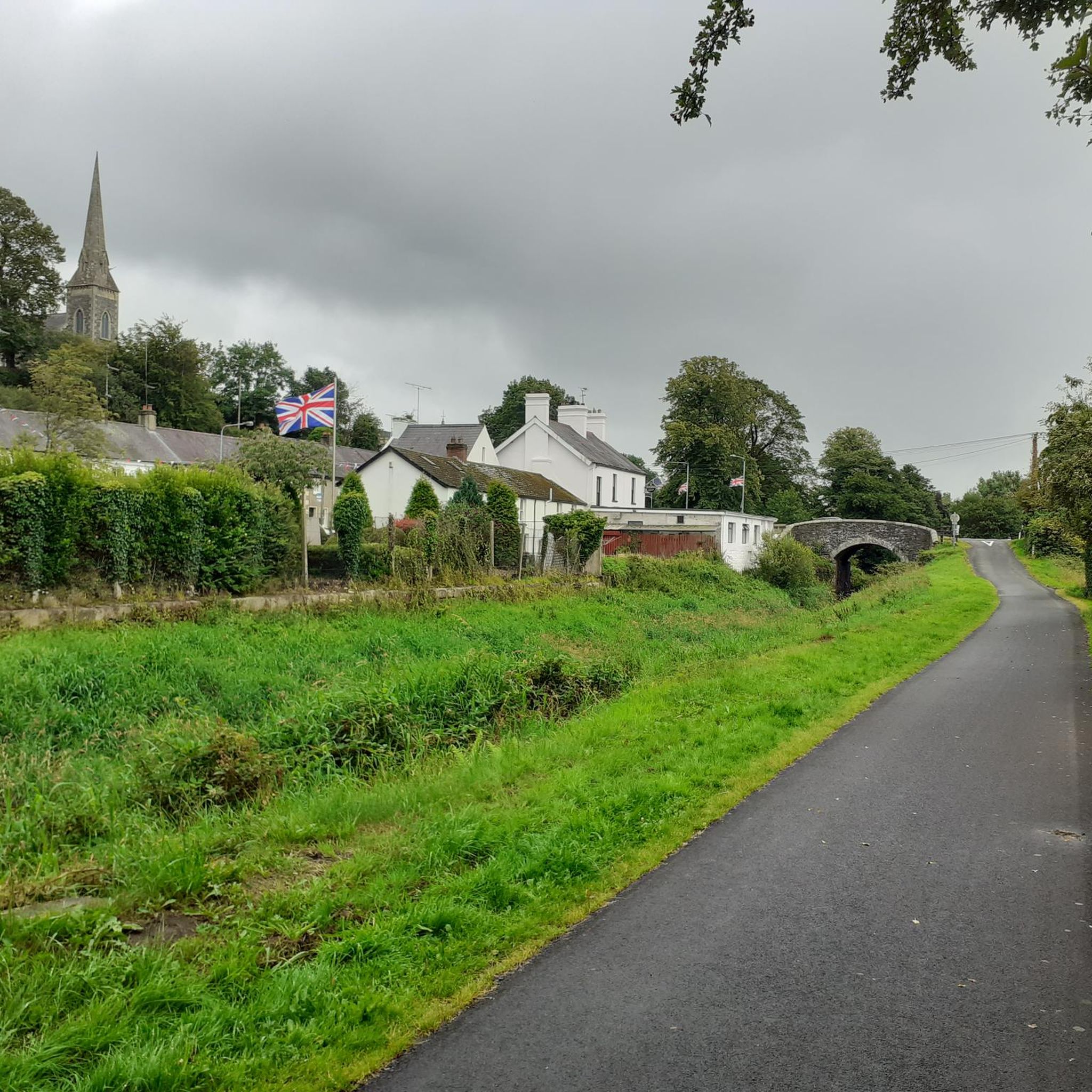
The small town of Scarva, nestled between green meadows and the quiet canal, offers a welcome break on my bike tour through Northern Ireland. Here you cycle on well-maintained paths past historic bridges and small villages that give you the feeling that time has stood still. The British flags fluttering along the side of the road remind you that you are in a culturally special area - a detail that reflects the identity of the region. The route is easy to cycle, the surrounding landscape is gently rolling, which makes for pleasant cycling. The view of wide fields and rolling hills invites you to slow down now and then and take in the peace and quiet. A special feature of Scarva is the annual Orange Order March, which transforms the village into a kind of open-air stage once a year and keeps the traditions of this region alive.
1
0
Frequently Asked Questions
How many road cycling routes are available around Aughlish?
There are over 30 road cycling routes around Aughlish, offering a diverse range of experiences. You'll find a balanced mix of moderate and difficult routes to suit various fitness levels.
What is the typical terrain like for road cycling in Aughlish?
The terrain around Aughlish is characterized by rural countryside and rolling hills, providing an undulating landscape. You can expect varied gradients, from moderate climbs to more challenging ascents, with quiet country roads that are often well-paved.
Are there challenging road cycling routes for experienced riders?
Yes, Aughlish offers several challenging routes for experienced road cyclists. For instance, the Climb by Rostrevor Forest – Warrenpoint Shore Road loop from Scarva is a difficult 59.3-mile (95.5 km) path featuring significant climbs and scenic stretches. Another demanding option is the Trassey Road – Scarva Village loop from Scarva, which covers 69.0 miles (111.1 km) through varied rural landscapes.
What kind of scenic views can I expect on road cycling routes near Aughlish?
Road cycling routes near Aughlish offer commanding views of the surrounding Sperrin Mountains, an Area of Outstanding Natural Beauty. You'll also pass through tranquil rural landscapes, quiet country roads, and have opportunities to encounter wildlife, providing a serene and immersive cycling experience.
Are there any historical sites or attractions I can visit while road cycling?
Yes, the region offers several points of interest. While not directly on every cycling route, the ancient Bronze Age Aughlish Stone Circles are a significant historical site nearby. You might also encounter attractions like Scarva Village, Gosford Castle, or the Newry Canal Towpath, which can be incorporated into your ride or visited as a cultural stop.
Are there circular road cycling routes available?
Many of the road cycling routes around Aughlish are designed as loops, allowing you to start and finish at the same point. Examples include the Scarva Village – Lackan Road loop from Scarva and the Scarva Village – Spelga Reservoir Hill Climb loop from Scarva, providing convenient options for exploration.
What is the best time of year for road cycling in Aughlish?
The best time for road cycling in Aughlish generally aligns with milder weather conditions, typically from late spring through early autumn. During these months, you'll experience more favorable temperatures and less chance of adverse weather, making for a more enjoyable ride through the rural landscapes and rolling hills.
Are there family-friendly road cycling options in the area?
While many routes around Aughlish feature undulating terrain and varied gradients, some moderate routes could be suitable for families with older children or those accustomed to longer distances. The region's quiet country roads often have minimal traffic, contributing to a safer environment for family rides, though specific dedicated family trails are not highlighted in this area.
Where can I find parking for road cycling routes around Aughlish?
Parking availability will vary depending on your chosen starting point. Many routes begin from villages or designated parking areas within the broader County Londonderry region. It's advisable to check specific route details or local information for parking options near your intended starting location.
Are there any cafes or places to stop for refreshments along the routes?
Yes, some routes pass through or near villages where you can find cafes or pubs for refreshments. For example, the Lottie's Café – Scarva Village loop from Scarva specifically mentions a cafe in its name, indicating potential stops. Exploring the villages along your chosen route will likely reveal suitable places to refuel.
What are some of the longer road cycling routes available?
For those seeking longer rides, routes like the Trassey Road – Scarva Village loop from Scarva covers 69.0 miles (111.1 km), and the Climb by Rostrevor Forest – Warrenpoint Shore Road loop from Scarva is 59.3 miles (95.5 km). These routes offer extended time in the saddle through the region's scenic landscapes.
What do other cyclists say about road cycling in Aughlish?
Over 200 road cyclists have explored the Aughlish area using komoot. They often appreciate the quiet, deserted rural mountain roads and the chance to encounter wildlife, providing a serene and immersive cycling experience through the region's diverse terrain and scenic views towards the Sperrin Mountains.
Most popular routes around Aughlish
Most popular attractions around Aughlish

Get inspired with the komoot mobile app


Explore more
Browse the best Road cycling routes in other regions.
