The best road cycling routes around Minas De Riotinto
140
riders
15
rides
Road cycling around Minas De Riotinto offers routes through a landscape shaped by 5,000 years of mining history, featuring distinct geological formations. The region is characterized by its "Martian" appearance, with the reddish Río Tinto river and vast, multi-colored open-pit mines like Corta Atalaya. Road cyclists can expect varied terrain across these unique mining landscapes and surrounding Mediterranean mountains.
Best road cycling routes around Minas De Riotinto
- The most popular road cycling route is Minas de Riotinto, Aracena, Santa Ana…
Last updated: July 17, 2026
18
riders
87.0km
04:31
1,540m
1,540m
This circular road cycling route immerses you in a unique landscape, combining the natural beauty of the Sierra de Aracena with the striking geology of the Minas de Riotinto. You'll…
8
riders
58.5km
03:15
1,140m
1,140m
This difficult 36.3-mile (58.5 km) road cycling route from Nerva offers 3734 feet (1138 metres) of climbing through Andalusian landscapes.

Sign up for free
8
riders
53.5km
03:04
950m
950m
Hard road ride. Very good fitness required. Some segments of this route may be unpaved and difficult to ride.
49
riders
101km
05:17
1,620m
1,620m
Hard road ride. Very good fitness required. Some segments of this route may be unpaved and difficult to ride.
10
riders
41.9km
02:29
950m
950m
Hard road ride. Very good fitness required. Some segments of this route may be unpaved and difficult to ride.
Get access to more routes and recommendations from other explorers.
Sign up for free
Already have an account?
Our route recommendations are based on thousands of hikes, rides, and runs completed by other people on komoot.
Start today with a free account
Your next adventure awaits.
Login or Signup
Tips from the Community

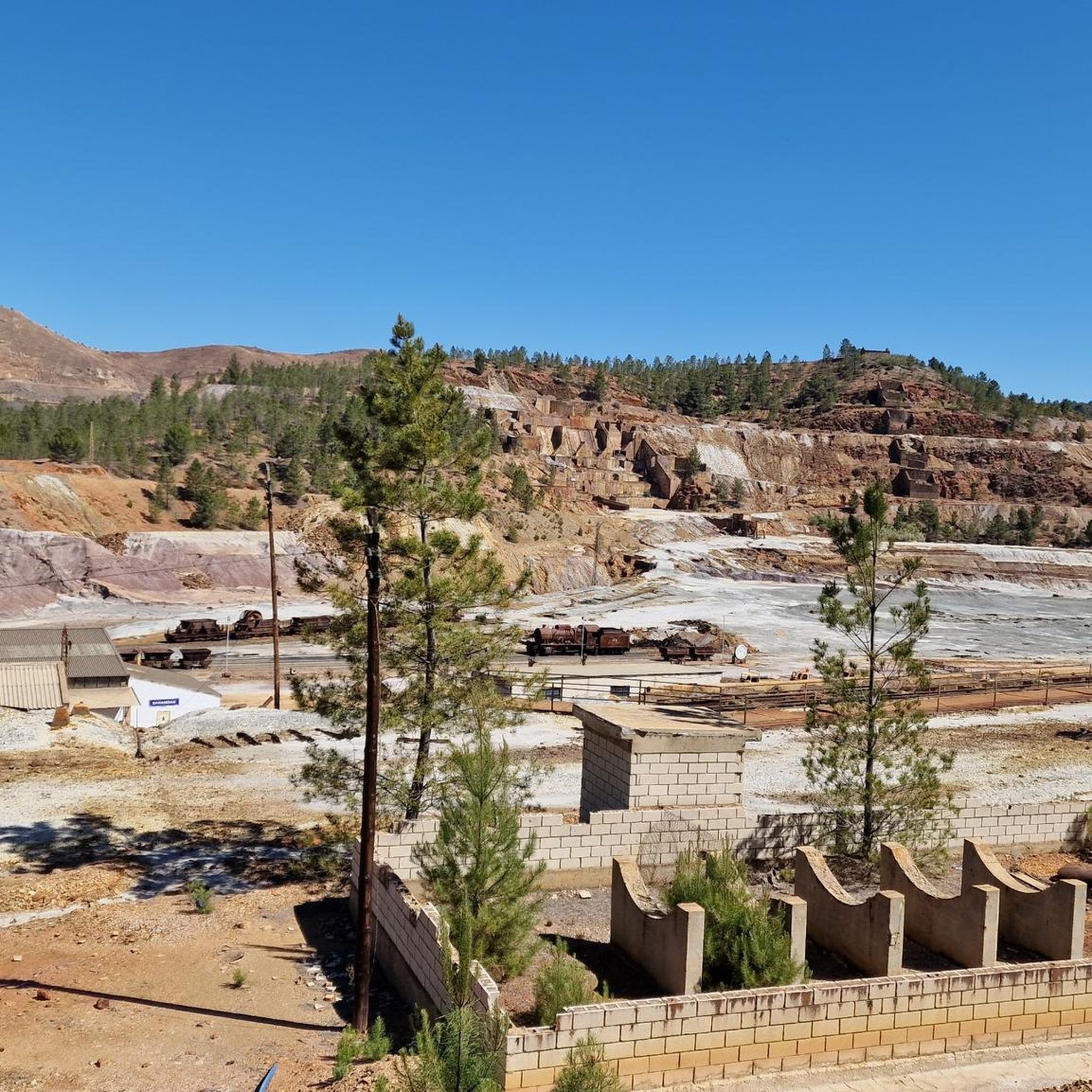
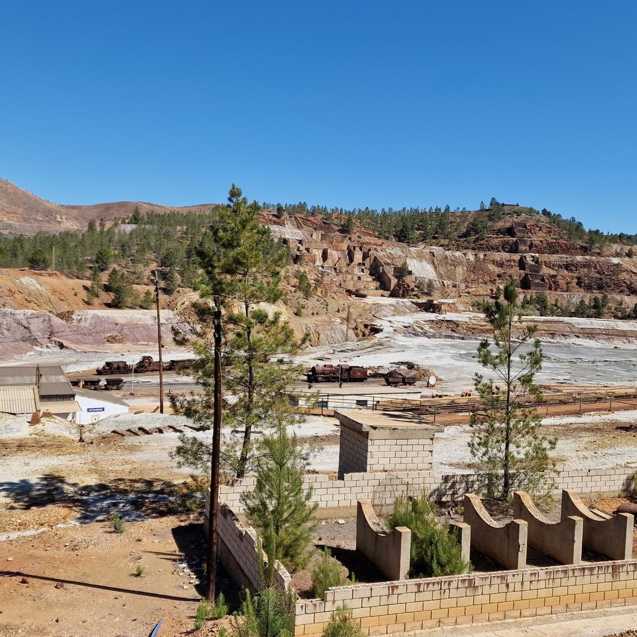
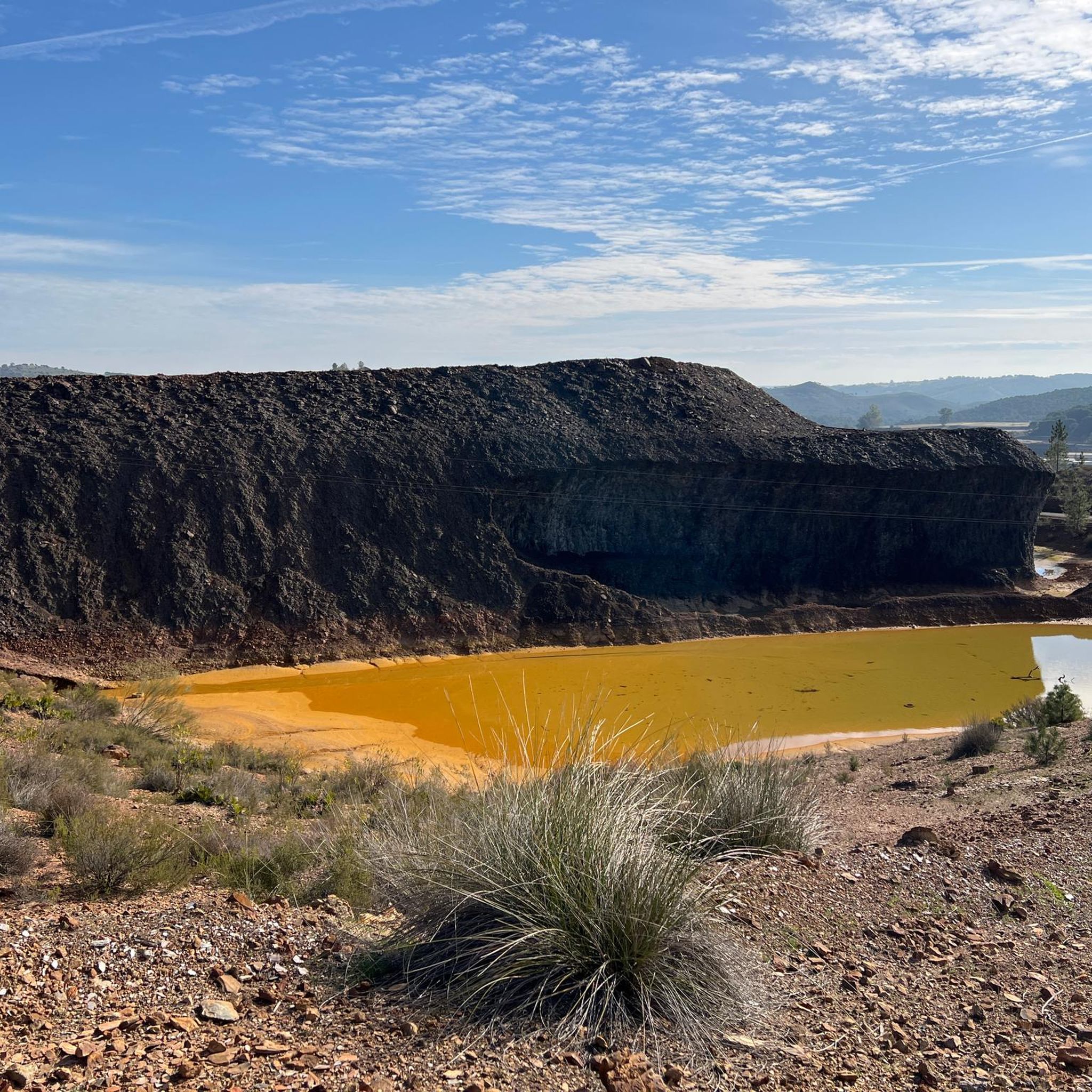
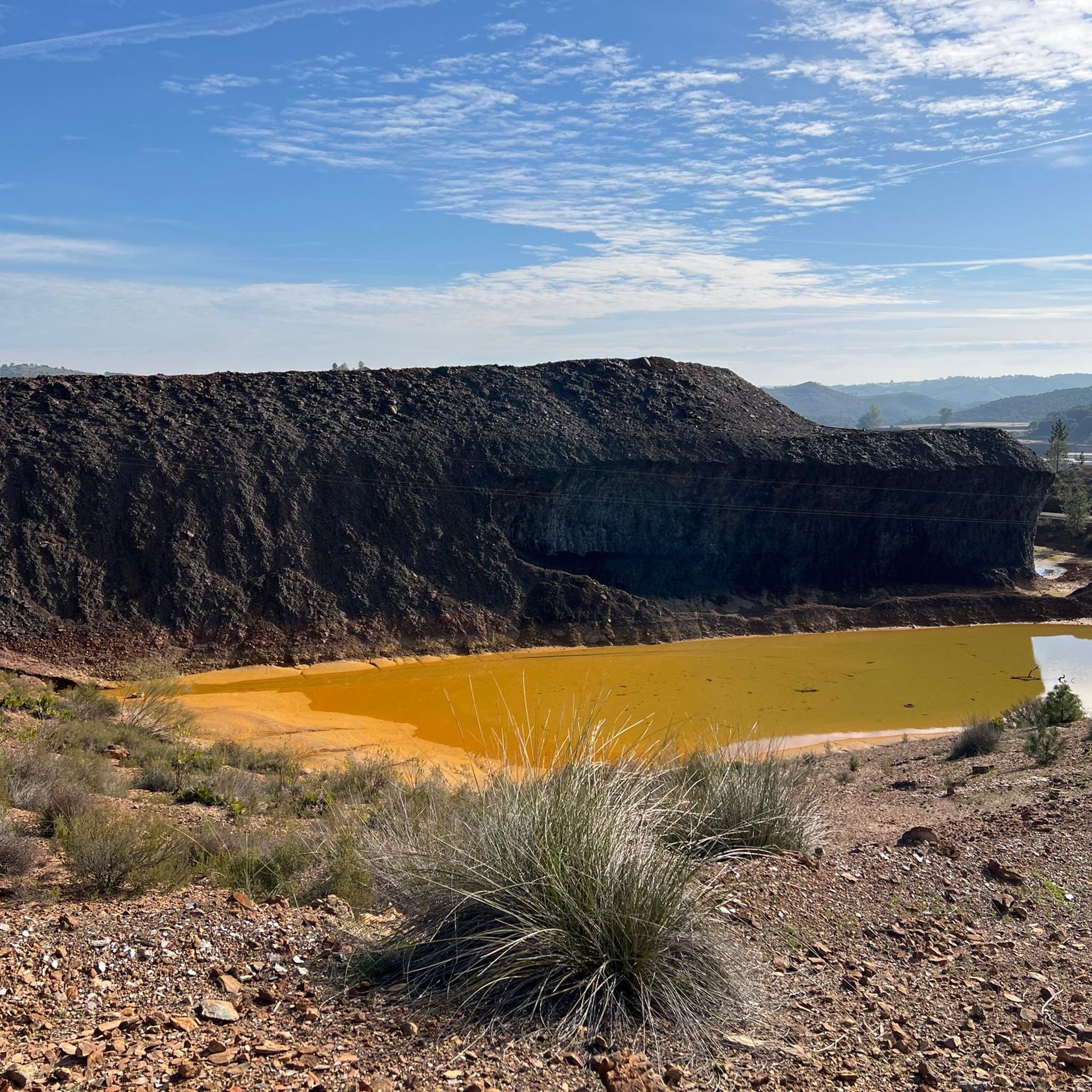
The Tinto River is famous for its intense red-colored waters and extreme acidity, caused by the oxidation of iron and sulfide minerals. It is so peculiar that NASA and other space agencies study it as a terrestrial analogue of Mars, as its extreme conditions host microorganisms capable of surviving in very hostile environments. Furthermore, the area has been mined for over 5000 years by Phoenicians, Romans, and other civilizations.
0
0


Obligatory stopping point if you take the road. There are incredible views even of the Rio Tinto mining railway.
0
0

Religious sanctuary of the town of Berrocal. Said congregation was divided into two buildings that represented two sides, the one above and the one below. That is why we still find the Hermitage of the Brotherhood of the Santa Cruz de Abajo and the one above.
1
1

Old station that is located a few kilometers from the town of Nerva and that was used to transport the materials extracted from the mine.
1
0
Road that passes through where there are the train tracks that brought the materials that came out of the mines to the town of Nerva. These tracks are currently still used by the tourist train that runs there, but the path allows you to see them perfectly as well as the river that is nearby.
3
0
Section of river that is crossed by the road but from where you can see the water passage before entering again towards the mountains near El Madroño.
1
0
This beautiful town is located between Alájar and Aracena, in the center of the Sierra de Aracena y Picos de Aroche Natural Park, one of the most important protected areas in the Community. Its cobbled streets, the Parish Church of San Juan Bautista, the public laundry and its crowded houses stand out.
0
0
Frequently Asked Questions
What kind of terrain can I expect on road cycling routes in Minas De Riotinto?
Road cycling in Minas De Riotinto offers varied terrain, primarily characterized by its unique "Martian" landscapes. You'll encounter routes through areas shaped by 5,000 years of mining history, featuring distinct geological formations, the reddish Río Tinto river, and vast, multi-colored open-pit mines. The broader region also includes Mediterranean mountains, offering diverse natural environments.
Are there challenging road cycling routes for experienced cyclists in Minas De Riotinto?
Yes, Minas De Riotinto is well-suited for experienced cyclists seeking a challenge. Out of the 15 available road cycling routes, 12 are classified as difficult. These routes often feature significant elevation gains and varied terrain. An example is the Minas de Riotinto, Aracena, Santa Ana La Real – circular route, which covers 54.1 miles (87.0 km) with over 1,500 meters of elevation gain.
Are there any easy or beginner-friendly road cycling routes in Minas De Riotinto?
While the region is known for its challenging terrain, there are a few moderate options available. Out of the 15 road cycling routes, 3 are classified as moderate. These routes offer a less strenuous experience while still allowing you to explore the unique landscapes. For a truly easy experience, the Vía Verde de Riotinto, though primarily for mountain biking, runs parallel to the Río Tinto and offers a flatter, scenic path.
What natural features can I see while road cycling in Minas De Riotinto?
The region is famous for its extraordinary natural features. You can witness the unique reddish hue of the Source of the Río Tinto, whose waters are known for their high acidity. The landscape is also dominated by gigantic, multi-colored open-pit mines like Corta Atalaya Mine and Peña del Hierro, which offer dramatic views. The area's distinct geology has even attracted NASA for research into other planets.
Are there any historical landmarks or viewpoints along the cycling routes?
Yes, the region is rich in historical mining landmarks and offers several viewpoints. You can see the vast Corta Atalaya Mine, once considered the largest opencast mine globally, and Peña del Hierro, which offers an underground walk. The Touristic Railway for Rio Tinto Mines and the historic Cachán Bridge are also notable points of interest, showcasing the area's mining heritage.
What is the best time of year to go road cycling in Minas De Riotinto?
While specific seasonal conditions are not detailed, the Mediterranean climate suggests spring and autumn are ideal for road cycling in Minas De Riotinto. These seasons typically offer milder temperatures, making longer rides more comfortable. Summers can be very hot, and winters might bring cooler, potentially wetter conditions, though the region generally experiences many sunny days.
Are there any circular road cycling routes in Minas De Riotinto?
Yes, several circular road cycling routes are available, allowing you to start and end your ride in the same location. Popular options include the Minas de Riotinto, Aracena, Santa Ana La Real – circular route (87.0 km) and the Nerva, Minas de Riotinto, Zalamea La Real – circular route (53.5 km). These loops are excellent for exploring the region's unique landscapes and mining heritage.
Are there long-distance road cycling routes available in Minas De Riotinto?
Yes, for those looking for longer rides, Minas De Riotinto offers several extended road cycling routes. The Old Zarandas-Naya Station – Riotinto Mines loop from Zarandas-Naya is a significant route covering approximately 97.2 km. Another substantial option is the Minas de Riotinto, Aracena, Santa Ana La Real – circular route, which is 87.0 km long.
What do other road cyclists enjoy the most about road cycling in Minas De Riotinto?
Road cyclists using komoot frequently praise the unique and dramatic landscapes of Minas De Riotinto. The "Martian" appearance, the distinct reddish Río Tinto river, and the vast open-pit mines create an unparalleled backdrop for cycling. Many appreciate the challenging nature of the routes and the opportunity to explore a region rich in history and geological wonders.
Can I find places to eat or drink near the road cycling routes?
While specific cafes or pubs are not detailed in the route information, the towns and villages within and around Minas De Riotinto, such as Nerva, Minas de Riotinto, and Zalamea La Real, are likely to offer local establishments where cyclists can refuel and relax. It's advisable to check local listings or plan your route to pass through these settlements.
Is public transport available to access the road cycling routes in Minas De Riotinto?
Information on specific public transport links directly to route starting points is not provided. However, the main towns in the region, such as Minas de Riotinto and Nerva, typically have bus connections to larger cities. Cyclists planning to use public transport should research local bus schedules to determine the best way to reach their desired starting points.
Are there any specific viewpoints along the road cycling routes that offer panoramic views?
Yes, the mining landscapes themselves offer dramatic panoramic views. The vast open-pit mines like Corta Atalaya Mine and Peña del Hierro provide stunning vistas of the multi-colored excavations. Additionally, routes like El Berrocal Viewpoint – El Madroño loop from Nerva suggest dedicated viewpoints along the way, allowing cyclists to appreciate the unique geology and scenery.
Most popular attractions around Minas De Riotinto

Get inspired with the komoot mobile app


Explore more
Browse the best Road cycling routes in other regions.
