The best road cycling routes around Les Neyrolles
4.4
(139)
2,988
riders
114
rides
Road cycling routes around Les Neyrolles are set within the Ain department of France, characterized by varied mountainous terrain and natural features. The region offers diverse landscapes, from challenging ascents in the Bugey mountains, including passes like Col de Colliard and the Grand Colombier, to tranquil routes around glacial lakes such as Lac de Sylans and Lac de Nantua. This area provides a range of road cycling experiences, with mostly paved surfaces winding through forests and along scenic lake shores.
…Last updated: October 7, 2026
4.0
(1)
14
riders
29.5km
01:25
380m
370m
Moderate road ride. Good fitness required. Mostly well-paved surfaces and easy to ride.
5.0
(1)
8
riders
26.0km
01:23
470m
470m
Moderate road ride. Good fitness required. Mostly well-paved surfaces and easy to ride.

6
riders
31.9km
01:57
760m
760m
Moderate road ride. Good fitness required. Mostly well-paved surfaces and easy to ride.
6
riders
24.4km
01:24
560m
560m
Moderate road ride. Good fitness required. Mostly well-paved surfaces and easy to ride.
7
riders
78.7km
03:46
1,050m
1,050m
Hard road ride. Very good fitness required. Mostly well-paved surfaces and easy to ride.
Get access to more routes and recommendations from other explorers.
Already have an account?
Our route recommendations are based on thousands of hikes, rides, and runs completed by other people on komoot.
Start today with a free account
Your next adventure awaits.

Tips from the Community

So I finished this superb day in Thoirette, at the Restaurant du Pont. And frankly… what a great idea! 🍽️ A very good meal to close this day as it should be. After spending several hours on the water, the pleasure of sitting down at the table and eating well takes on another dimension!
0
0

The Lac de Nantua is a superb body of water of 141 hectares. In the heart of the Jura, it offers an ideal setting for practicing a multitude of sports. It is even possible to swim in its waters.
2
0
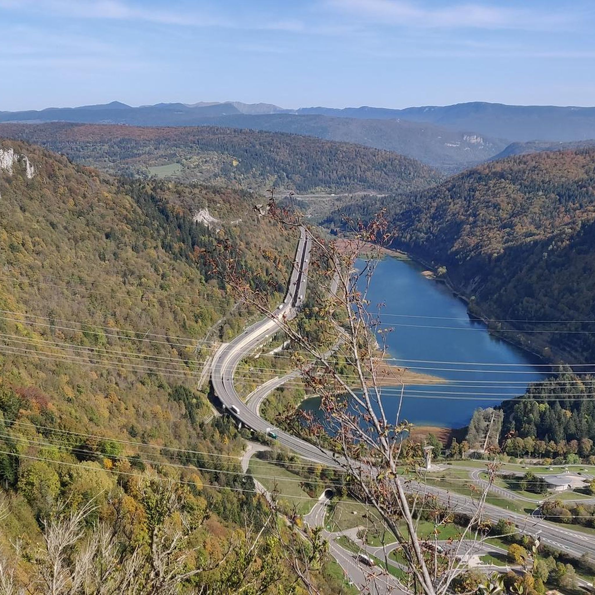
The Peney viewpoint overlooks Lake Sylans, on which it offers a beautiful view. Classified since 1909, one can distinguish on its banks the ruins of the old ice factories which commercialized the ice extracted from the lake until 1917. The passage is located at the level of the tunnel of the same name.
0
0

The bridge separates two departments, the Jura and the Ain. "Iron bridge. For several centuries, the Ain was crossed at Thoirette using a ferry, called Christouphe's ferry, named after the commune where the passenger resided. From 1808 to 1811, the riparian communes contributed to building a bridge in place of this ferry. The project had been drawn up by Mr. Cordier, from Orgelet, an engineer then in charge of directing the works for the Simplon road. Various obstacles opposed the execution of this work. It was not until 1829 that an iron bridge was built, which collapsed in 1843. The Ain department has just replaced it with an iron bridge currently open to traffic". Statistique de la France - 1855 - Ministère de l'Agriculture by Imprimerie Impériale in Paris - p53.
0
0
The bridge separates two departments, the Jura and the Ain. "Iron bridge. For several centuries, the Ain was crossed at Thoirette by means of a ferry, known as the bac de Christouphe, the name of the commune where the passenger resided. From 1808 to 1811, the riparian communes clubbed together to build a bridge in place of this ferry. The project had been drawn up by Mr. Cordier, of Orgelet, an engineer then in charge of the direction of the Simplon road works. Various obstacles opposed the execution of this work. It was only in 1829 that an iron bridge was built, which collapsed in 1843. The department of Ain has just replaced it with an iron bridge currently open to traffic". Statistique de la France - 1855 - Ministère de l'Agriculture par Imprimerie Impériale à Paris - p53.
0
0

Beautiful, simple, easy walk; lots of traffic noise on the "road" section, a bit of a shame, but the color of the water is magical
2
0

Unfortunately I was unlucky with the weather, but even as I drove past the place looked very nice, lots of grass and a place to swim.
1
0

Frequently Asked Questions
How many road cycling routes are available around Les Neyrolles?
Les Neyrolles and the surrounding Bugey region offer a wide variety of road cycling experiences, with over 110 routes available on komoot. These routes cater to all levels, from easy rides to very challenging ascents.
What kind of terrain can I expect on road cycling routes in Les Neyrolles?
The terrain around Les Neyrolles is incredibly diverse, ranging from tranquil routes along glacial lakes like Lake Nantua and Lake Sylans, to demanding climbs in the Bugey Mountains. You'll encounter undulating hills, challenging mountain passes such as Col de Bérentin, and scenic plateaus like the Plateau de Retord, often with breathtaking views of Mont Blanc on clear days.
Are there easy road cycling routes suitable for beginners or casual riders?
Yes, there are several easy routes perfect for beginners or those looking for a relaxed ride. One popular option is the Lake Nantua – Lac de Nantua loop from Nantua, which is 28.6 km long and offers scenic views around Lac de Nantua with minimal elevation gain.
Where can I find challenging road cycling routes with significant elevation gain?
For experienced cyclists seeking a challenge, the Bugey region is renowned for its demanding ascents. The formidable Grand Colombier, a frequent feature in the Tour de France, offers multiple 'hors-catégorie' climbs with gradients up to 22%. While not directly from Les Neyrolles, a very long and difficult route from Nantua, the View of Lake Nantua – Lake Genin loop, covers nearly 200 km with over 3,800 meters of elevation gain, traversing mountainous terrain and passes. You can find more information about challenging climbs in the area on the Bugey Sud Tourism website.
What scenic views or natural landmarks can I see along the routes?
Road cycling routes around Les Neyrolles offer stunning natural beauty. You can enjoy the shifting sapphire and emerald hues of Lake Nantua, the pure waters of Lake Sylans, and the picturesque Lake Genin, often called 'the little Canada of Haut-Bugey'. Many routes also provide panoramic views over Lake Nantua and, from higher elevations like the Plateau de Retord, glimpses of Mont Blanc.
Are there any circular road cycling routes around Les Neyrolles?
Yes, many routes in the area are designed as loops, allowing you to start and finish in the same location. For example, the Lake Nantua – Lac de Sylans loop from Nantua is a moderate 25.7 km ride that takes you around the beautiful Lac de Sylans.
What do other cyclists say about road cycling in Les Neyrolles?
The road cycling routes around Les Neyrolles are highly regarded by the komoot community, with an average rating of 4.5 stars from over 100 reviews. Cyclists often praise the region's diverse landscapes, the variety of routes for different skill levels, and the generally good road conditions with low traffic, especially on lesser-known climbs.
What is the best time of year to go road cycling in Les Neyrolles?
The best time for road cycling in Les Neyrolles is typically from spring through autumn. During these seasons, the weather is generally mild, and the natural landscapes are at their most vibrant. Summer offers the warmest temperatures, while spring and autumn provide cooler rides and beautiful foliage. Always check local weather forecasts before heading out, especially for mountain passes.
Are there specific events or dedicated cycling days in the region?
Yes, the Bugey region is very cycling-friendly. The Grand Colombier, a major climb in the area, hosts special 'cycling days' several times a year. On these days, the roads are closed to cars, offering a unique and safe opportunity for cyclists to tackle its challenging ascents, often with refreshments provided at the summit. For more information on cycling events and routes, you can visit the Ain Tourisme website.
Are there any family-friendly road cycling options in Les Neyrolles?
While many routes involve significant elevation, there are easier sections and routes suitable for families or those preferring flatter terrain. The areas around the lakes, such as Lake Nantua and Lake Sylans, often provide more gentle gradients and scenic paths that can be enjoyed by a wider range of cyclists. Always check the route's difficulty and elevation profile on komoot before setting out.
Most popular routes around Les Neyrolles
Most popular attractions around Les Neyrolles

Get inspired with the komoot mobile app


Explore more
Browse the best Road cycling routes in other regions.
