The best walks and hikes around Carnoët
4.4
(850)
3,628
hikers
48
hikes
Hiking around Carnoët offers diverse landscapes, from ancient forests to river valleys and coastal paths. The region is characterized by the expansive Carnoët Forest, the scenic Laïta river, and rugged coastlines traversed by the GR34. Hikers can explore varied terrain, including woodlands, riverside trails, and areas with unique granite rock formations. The area also features cultural sites like the Valley of the Saints, providing panoramic views of the surrounding countryside.
Best hiking trails around Carnoët
- The most popular hiking route…
Last updated: October 5, 2026
5.0
(1)
8
hikers
2.60km
00:45
60m
60m
Easy hike. Great for any fitness level. Easily-accessible paths. Suitable for all skill levels.
4.5
(6)
22
hikers
5.70km
01:31
60m
60m
Easy hike. Great for any fitness level. Easily-accessible paths. Suitable for all skill levels.

4.0
(1)
11
hikers
Easy hike. Great for any fitness level. Easily-accessible paths. Suitable for all skill levels.
5.0
(1)
5
hikers
13.6km
03:43
200m
200m
Moderate hike. Good fitness required. Easily-accessible paths. Suitable for all skill levels.
5.0
(7)
9
hikers
8.43km
02:12
60m
60m
Moderate hike. Good fitness required. Easily-accessible paths. Suitable for all skill levels.
Get access to more routes and recommendations from other explorers.
Already have an account?
Our route recommendations are based on thousands of hikes, rides, and runs completed by other people on komoot.
Start today with a free account
Your next adventure awaits.



Tips from the Community

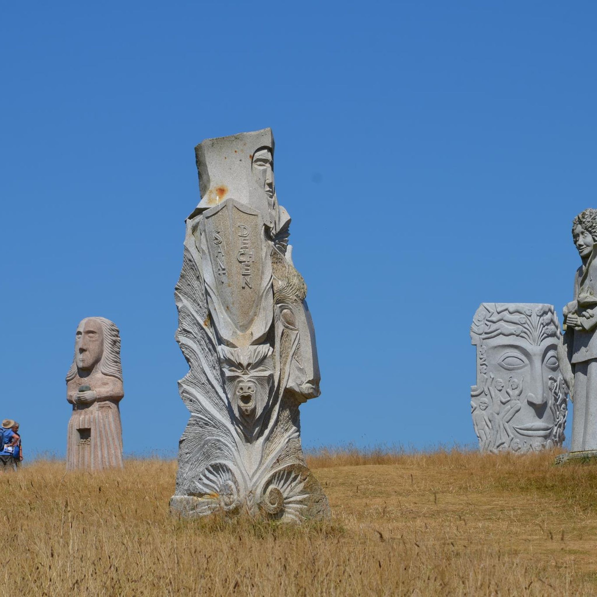
There are only seven photos posted here, but they show more clearly than words can, a selection of the stone-carved diversity of the Breton heavenly host of saints – in this very special case a hill called „Vallée des Saints“.
0
0

The Mount give a wonderful panoramic view of the statues
0
0
A great place, bring a picnic, maybe too many saints and not enough information
0
0


Saint Non is a significant figure in Welsh and Breton hagiography.
0
0

Beautifully done street sculpture. Why not position one of your friends in the peloton and grab a photo of them riding with Anquetil et al?
0
0
very pleasant
0
0
The collection of more than 200 photos for this highlight shows more clearly than words can the diversity of the Breton saints' heaven carved in stone - in this very special case a hill called "Vallée des Saints".
1
0
Frequently Asked Questions
How many hiking trails are available in Carnoët?
Carnoët offers a wide variety of hiking opportunities, with over 40 trails recorded on komoot. These range from easy strolls to more moderate routes, ensuring options for different skill levels.
Are there easy hiking trails suitable for beginners or casual walkers in Carnoët?
Yes, Carnoët has plenty of easy trails. There are 17 easy routes available, perfect for beginners or those looking for a relaxed walk. A good example is the Valley of the Saints – Saint-Gildas Chapel loop from Carnoët, which is 1.7 miles (2.7 km) and explores the unique monumental statues.
What kind of landscapes can I expect to see while hiking in Carnoët?
Hiking in Carnoët offers a diverse range of landscapes. You can explore the lush, ancient Carnoët Forest with its centenarian trees and the scenic Laïta river, or discover dramatic coastlines along the GR34 with stunning views of the Atlantic. The region also features unique granite rock formations, such as those found in the Gorges du Corong.
Are there any historical sites or attractions to visit along the trails in Carnoët?
Absolutely. Carnoët is rich in history and culture. You can hike to the unique Valley of the Saints, featuring over 200 monumental granite statues. The historic Abbaye Saint-Maurice de Carnoët is nestled by the Laïta river within the forest, and you can also discover the ruins of Château de Carnoët during your treks.
Where can I find waterfalls or unique natural features in the Carnoët area?
While hiking in Carnoët, you can discover several natural wonders. The Gouffre de Huelgoat Waterfall is a notable attraction nearby. Additionally, the Gorges du Corong, a Natura 2000 protected area, presents a striking landscape of granitic chaos where the Follézou stream carves its way through massive rocks, offering impressive rock formations.
What do other hikers say about the trails in Carnoët?
The hiking routes in Carnoët are highly rated by the komoot community, with an average score of 4.5 stars from over 600 reviews. Hikers often praise the varied terrain, from dense woodlands and scenic river valleys to refreshing coastal paths, and appreciate the options available for different ability levels.
Are there any circular hiking routes in Carnoët?
Yes, many trails in Carnoët are designed as circular routes, allowing you to start and end at the same point. For instance, the Saint-Gildas Chapel – Valley of the Saints loop from Carnoët is a popular circular option that takes you through the Valley of the Saints and its natural surroundings.
Are there options for longer, more challenging hikes in Carnoët?
Carnoët offers 23 moderate trails for those seeking a longer or more challenging experience. An example is the Hiking loop from Carhaix-Plouguer, a 7.2 miles (11.6 km) path that leads through varied terrain, including forested areas and open landscapes.
Can I bring my dog on hikes around Carnoët?
Many trails in Carnoët are suitable for dogs, especially those in the extensive forests and along the Laïta river. However, it's always recommended to check local signage for specific restrictions, particularly in protected areas or near wildlife habitats. Always keep your dog under control and clean up after them.
What is the best time of year to go hiking in Carnoët?
Carnoët offers pleasant hiking conditions throughout much of the year. Spring and autumn provide mild temperatures and beautiful scenery, with vibrant foliage in the forests. Summer is also popular, especially for coastal walks, though it can be busier. Winter hikes can be serene, particularly in the woodlands, but be prepared for cooler, potentially wetter weather.
Are there specific forest trails worth exploring in Carnoët?
The Forêt de Carnoët (also known as Toulfoën) is a primary destination for forest hiking. Its trails wind through lush woodlands, featuring centenarian trees and mossy paths, often alongside the Laïta river. You can discover picturesque spots like the 'Fontaine aux Loups' and 'Pont du Diable' within this ancient forest.
Can I access coastal paths for hiking near Carnoët?
Yes, Carnoët is traversed by the famous GR34, also known as the Customs Trail, which hugs the Brittany coastline. This trail offers stunning panoramic views of the Atlantic Ocean, leading hikers along rugged cliffs, white sandy coves, and beautiful beaches such as Le Pouldu, Bellangenêt, and Kérou.
Are there any specific parking considerations for hikers in Carnoët?
While specific parking details vary by trailhead, many popular hiking areas in Carnoët, especially near major attractions like the Valley of the Saints or access points to the Forêt de Carnoët and coastal paths, typically offer designated parking facilities. It's advisable to check route descriptions on komoot for specific parking information for your chosen trail.
Most popular attractions around Carnoët

Get inspired with the komoot mobile app


Explore more
Browse the best Hikes in other regions.
