The best cycling routes around Héninel
4.5
(242)
2,089
riders
245
rides
Touring cycling around Héninel, situated in the Pas-de-Calais department, features wide-open countryside and uncrowded roads. The landscape is characterized by a mosaic of fields, rolling hills, and tranquil waterways, offering a serene cycling experience. Proximity to Arras provides access to historical routes, including those related to World War I. The area's well-maintained paths and "Voies Vertes" cater to diverse cycling preferences.
Best touring cycling routes around Héninel
- The most popular touring cycling route is Scarpe riverbanks – The Scarpe by…
Last updated: July 29, 2026
32
riders
34.3km
02:47
290m
290m
Moderate bike ride. Good fitness required. Mostly paved surfaces. Suitable for all skill levels.
10
riders
16.6km
01:14
100m
110m
Easy bike ride. Great for any fitness level. Mostly paved surfaces. Suitable for all skill levels.

Sign up for free
4
riders
17.5km
01:04
110m
110m
Easy bike ride. Great for any fitness level. Mostly paved surfaces. Suitable for all skill levels.
6
riders
36.8km
03:00
280m
280m
Hard bike ride. Good fitness required. You may need to push your bike for some segments of this route.
4.0
(1)
3
riders
23.7km
01:24
140m
140m
Easy bike ride. Great for any fitness level. Mostly paved surfaces. Suitable for all skill levels.
Get access to more routes and recommendations from other explorers.
Sign up for free
Already have an account?
Our route recommendations are based on thousands of hikes, rides, and runs completed by other people on komoot.
Start today with a free account
Your next adventure awaits.
Login or Signup



Tips from the Community

This small farming village has a rich history and is known for its two Commonwealth War Graves Commission cemeteries from the First World War. The village has a church, a castle, and a range of amenities including bars, a supermarket, a chemist and a post office. Many residents commute to nearby towns such as Arras and Bapaume for work.
9
0
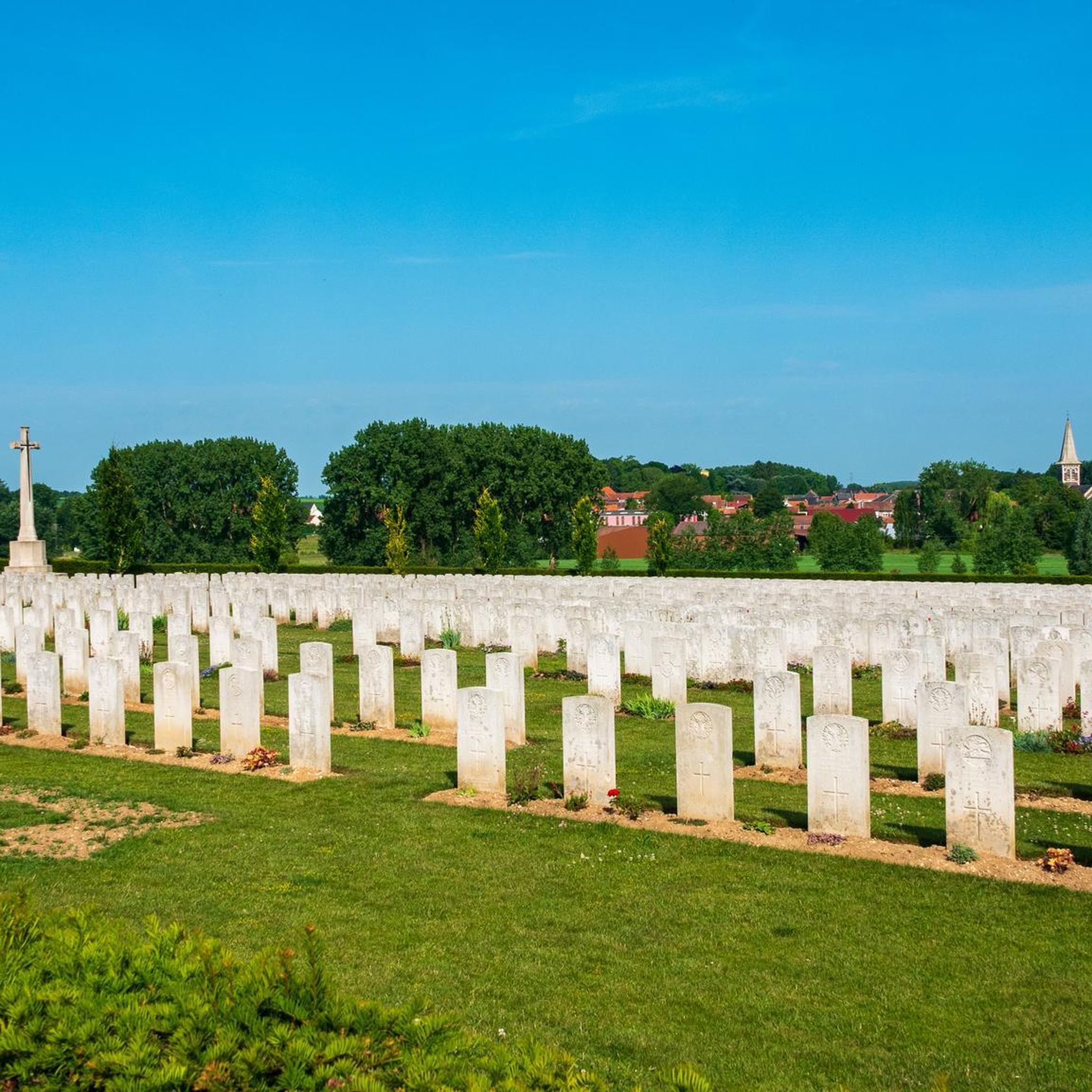
The 21st Division captured Héninel on 12 April 1917 and advanced eastwards on the two following days. The 33rd Division then took over the attack. These two divisions are largely represented in the cemetery. In April 1918 this ground was lost, and the eleven German graves in Plot I, Rows D and E, were made when the cemetery was in German hands. After the Armistice, graves were brought in from a wide area round Héninel. The cemetery now contains 307 Commonwealth burials of the First World War, 104 of them unidentified. The cemetery was designed by Sir Edwin Lutyens.
8
0
Wancourt was captured on 12 April 1917 after very heavy fighting and the advance was continued on the following days. The cemetery, called at first Cojeul Valley Cemetery, or River Road Cemetery, was opened about ten days later; it was used until October 1918, but was in German hands from March 1918 until 26 August, when the Canadian Corps recaptured Wancourt. At the Armistice, the cemetery contained 410 graves, but was very greatly increased in the following years when graves were brought in from a number of small cemeteries and isolated positions on the battlefields south-east of Arras. The cemetery now contains 1936 burials and commemorations of the First World War. 829 of the burials are unidentified but there are special memorials to 76 casualties known or believed to be buried among them, and to 20 who were buried in Signal Trench Cemetery whose graves were destroyed in later battles.
9
0
Bapaume was one of the war objectives in the Battle of the Somme. In 1916, Bapaume was one of the towns considered by the Allies as strategic objectives in the Battle of the Somme. Bapaume was occupied by the Germans on 26 September 1914 and then by the British on 17 March 1917. The town hall was destroyed on 25 March by a delayed action mine left by the Germans, killing 24 people, including Australian soldiers and two French MPs. On 24 March 1918, the Germans retook the town. In 1918, the Second Battle of Bapaume, from 21 August to 3 September, was part of the second phase of the Battle of Amiens, the British and Commonwealth attack that marked the turning point in the First World War on the Western Front and the beginning of the Allies' Hundred Days Offensive. Improved armoured support and artillery bombardments weakened once impregnable positions and helped Allied troops to blow holes in trenches. On 29 August, after heavy fighting, the New Zealand Division occupied Bapaume, having broken through the very strong trench system at Le Transloy-Loupart with the British 5th Infantry Division and taken many other strong points around the border.
6
0
Favreuil is a village 23 km south of Arras. The church of St. Georges, rebuilt with most of the commune, after the First World War. There is also a cemetery of the Commonwealth War Graves Commission. And there is a war memorial in memory of the victims of the First World War, called Monument à Favreuil. The monument is located on the Place de la Mairie in Favreuil and was erected in 1925
5
0
Mory Street Military Cemetery is a British military cemetery located in Saint-Léger, Pas-de-Calais. The cemetery was laid out in 1917 and designed by William Cowlishaw. It commemorates 66 First World War soldiers, 5 of whom are unidentified. The cemetery has a square plan with a semi-circular projection containing the Cross of Sacrifice.
8
0
Places of Interest The church of St.Leger, rebuilt, as was the whole village, after the First World War. The Commonwealth War Graves Commission cemetery. The village was situated in an area that was heavily fought over during the war. There are several military cemeteries in the area, including the Heninel-Croisilles Road Cemetery, where many soldiers who fought near Saint-Léger are buried. An interesting anecdote is that Saint-Léger and the surrounding villages changed hands several times during the war between the Allies and the German troops. This caused much destruction and suffering among the local population.
9
0

Reflection on the course for fallen tommies 💮
0
0
Frequently Asked Questions
How many touring cycling routes are available around Héninel?
There are over 240 touring cycling routes around Héninel, offering a wide variety of options for different skill levels and preferences. The komoot community has explored these routes over 2000 times, highlighting the area's popularity for cycling.
What kind of terrain can I expect on touring cycling routes near Héninel?
The terrain around Héninel is characterized by wide-open countryside, a mosaic of fields, and rolling hills. You'll find uncrowded roads and tranquil waterways, with routes ranging from mostly paved surfaces to some unpaved segments, especially along riverbanks and through natural parks. The region also features 'Voies Vertes' (greenways) for traffic-free cycling.
Are there easy touring cycling routes suitable for beginners or casual riders?
Yes, Héninel offers many easy touring cycling routes. For example, the Tilloy British Cemetery – Tigris Lane Cemetery loop from Tilloy-lès-Mofflaines is an easy 16.4 km path, and the Croisilles loop from Wancourt is another easy 17.5 km option, both perfect for a relaxed ride.
Are there more challenging routes for experienced touring cyclists?
Absolutely. For those seeking a greater challenge, routes like the Scarpe riverbanks – The Scarpe by bike loop from Beaurains cover 53.3 km with significant elevation changes, making it a difficult route. Another challenging option is the Pelves – The Scarpe by bike loop from Beaurains, which is 36.8 km and also rated difficult.
What are some interesting landmarks or attractions I can see along the touring cycling routes?
Many routes pass by significant historical sites and natural features. You can explore World War I battlefields and cemeteries, or cycle along the scenic Scarpe riverbanks. Nearby Arras offers cultural attractions like the Arras Citadel and the Arras Town Hall and Belfry. The Wancourt British Cemetery – Croisilles loop from Haucourt specifically combines historical discovery with cycling.
Are there any circular touring cycling routes around Héninel?
Yes, many of the touring cycling routes around Héninel are designed as loops, allowing you to start and finish in the same location. Examples include the Scarpe riverbanks – The Scarpe by bike loop from Beaurains, the Wancourt British Cemetery – Croisilles loop from Haucourt, and the Pelves – The Scarpe by bike loop from Beaurains.
What is the best time of year for touring cycling in Héninel?
The region is generally pleasant for cycling from spring through autumn. The wide-open countryside and rolling hills are beautiful under the spring blossoms and vibrant autumn colors. Summer offers longer daylight hours, though it can be warmer. Always check local weather forecasts before heading out.
Can I find family-friendly touring cycling routes in the Héninel area?
Yes, the region's well-maintained paths and 'Voies Vertes' (greenways) provide excellent opportunities for family-friendly cycling. Many easy and moderate routes with minimal elevation are suitable for families, allowing for a relaxed exploration of the countryside and charming villages.
Are there options for public transport to reach Héninel or connect with cycling routes?
Héninel is a small municipality, but its proximity to Arras (just 11.7 km away) means you can often use public transport to reach Arras, which serves as a hub for cycling routes. From Arras, you can cycle to Héninel or other starting points for tours. Specific public transport options directly to Héninel may be limited, so planning ahead is recommended.
Where can I find parking for my car when starting a touring cycling route near Héninel?
Many villages and towns in the Pas-de-Calais region, including those near Héninel, offer public parking facilities, often near town centers or trailheads. If starting a route from a specific village like Beaurains, Haucourt, or Wancourt, look for designated parking areas. Arras, being a larger town, also has ample parking options.
What do other touring cyclists enjoy most about cycling in Héninel?
The area is highly rated by the komoot community, with an average score of 4.6 stars from nearly 200 reviews. Reviewers often praise the serene cycling experience, the uncrowded roads, the beautiful mosaic of fields, and the combination of natural landscapes with historical sites, particularly those related to World War I.
Are there any regional natural parks accessible by bike from Héninel?
Yes, Héninel is situated within the broader Hauts-de-France region, which features several regional natural parks. The Regional Nature Park of the Caps et Marais d'Opale is a significant draw, offering diverse landscapes from hedged farmland to forests. The Scarpe-Escaut Natural Park is also known for its cycling-friendly routes. These parks provide extensive opportunities for scenic rides through varied terrain. For more information on the region's natural parks, you can visit Hauts-de-France Tourism.
Most popular attractions around Héninel

Get inspired with the komoot mobile app


Explore more
Browse the best Cycling routes in other regions.
